BikeAble™
Graphic by RTC
What is BikeAble?
BikeAble™ is a customizable tool for analyzing community connectivity and evaluating how improvements to the bicycle network can help residents reach key destinations safely by bike.
How does BikeAble work?
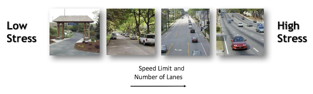
Assessing low-stress bicycling connectivity involves determining whether a person can reach key destinations without having to bike on high-stress roadways. With BikeAble, we can use mapping technology to model the low-stress bike route options available from any origin to any destination. Doing this for a large number of origins and destinations allows us to aggregate the results to show not just how connected one household is to key destinations, but how well connected an entire community is.
BikeAble is a customizable tool cited by the Federal Highway Administration for its ability to analyze multimodal connectivity and evaluate how improvements to the bicycling network can help people reach destinations safely by bike. See completed BikeAble studies.
What sorts of questions can BikeAble help my community answer?
As a baseline, BikeAble can help a community assess the state of its low-stress bicycle network and map the likely flow of “interested-but-concerned” bicyclists throughout the network. The analysis will produce a series of detailed maps showing the relative level of connectivity of various parts of the community. Planners and decision-makers can then see which areas benefit from high levels of low-stress connectivity and which areas suffer from poor connectivity, as well as which routes have the greatest potential for use by stress-averse bicyclists to reach key destinations.
Beyond this baseline analysis, the BikeAble tool is highly customizable and can be used to assess low-stress bicycle connectivity in several forms:
1. The specific connectivity assessment.
By changing the list of origins and destinations, or by altering the model’s parameters, the tool can help answer more specific questions about connectivity within the community. For example, BikeAble can help a community make such decisions as: whether economically disadvantaged residents have low-stress access to job centers; whether parts of the community with poor health outcomes have access to stores selling healthy foods, trails for low-cost exercise, or doctors’ offices; or whether certain communities lack access to government buildings or facilities.Because BikeAble is so customizable, it can help communities assess any sort of connectivity question of concern, so long as sufficient data exists or can be generated.
2. The location siting decision.
BikeAble can be used to select locations that would maximize access by bike. For example, it can help a bike shop owner or franchisee determine which potential location might be most accessible to customers arriving by bike or on foot. It can also help planners determine where a major employer might best locate to encourage biking to work and meet Transportation Demand Management (TDM) goals. And it can help government officials locate public resources such as parks, libraries, schools and similar community-serving destinations where they can best be reached by people who may lack access to private automobiles.
3. The network improvement alternatives.
Most often, BikeAble is used by community transportation decision-makers and advocates to discern how changes to the network might affect connectivity. BikeAble can model the connectivity effects of adding trails or on-road bicycle infrastructure, conducting road diets or removing segments of roadway altogether. By running the tool iteratively, planners can assess the relative low-stress connectivity effect of entire bicycle plans or capital improvement plans to rank and prioritize those that would enhance low-stress connectivity the most.
What’s the best feature of BikeAble™?
You don’t have to choose. Once your community’s data is used to customize the model, RTC’s analysts can help you to learn everything the model will reveal about low-stress bicycle connectivity. We will work with you so that your community gets answers to the specific questions it needs.
Are you interested in working with us to analyze your community, and the steps to make it more bikeable?
Project Spotlight
Reconnecting Milwaukee:
A BikeAble™ Study of Opportunity, Equity and Connectivity
Milwaukee’s exemplary trails, including the Oak Leaf Trail and Hank Aaron Trail, serve as critical infrastructure for city residents, connecting communities and offering transportation and recreation benefits to those who use them. But the benefits that trails bring are not equitably shared among the residents who live there.
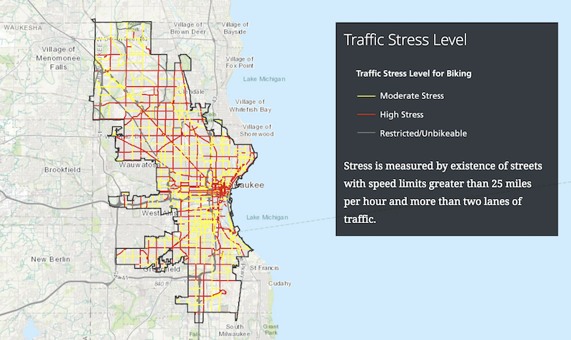
A new RTC study finds that neighborhoods experiencing inequality in Milwaukee—those where a concentration of the population lives under the poverty line, is unemployed, does not have a high school degree, does not own a vehicle and is either African American or Hispanic—disproportionately lack access to biking and walking facilities. The study, Reconnecting Milwaukee—A BikeAble™ Study of Opportunity, Equity and Connectivity, explores current access for bicyclists and pedestrians to employment centers and schools as well the impact that potential plans for new trails and biking facilities could have on the city. Read press release.
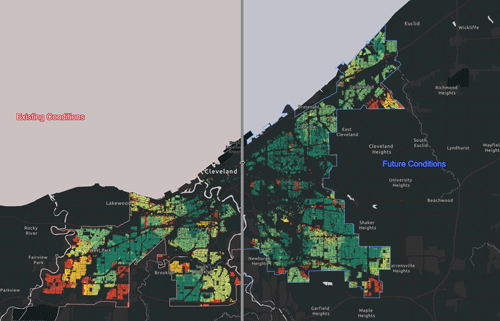
Advancing Cleveland’s Active Transportation Agenda
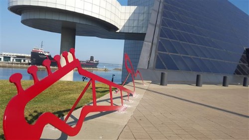
RTC partnered with the City of Cleveland, other public agencies and local bike advocates to conduct a BikeAble study with the intention of better understanding the potential impact of each potential project. This study, Advancing Cleveland’s Active Transportation Agenda, reveals how strategic, prioritized investments in trails and biking infrastructure could improve connectivity for residents citywide and examines how these investments bring value to neighborhoods experiencing inequality.