Connecting the Keys: Florida Keys Overseas Heritage Trail
Here’s an excellent feature from the Winter 2014 edition of Rails to Trails magazine. One of many perks provided when you become an RTC member, our quarterly magazine includes lots of great stories like this.
When oil magnate Henry Flagler’s East Coast Railway reached Key West, Fla., in 1912, it was hailed by some as the “Eighth Wonder of the World.” Others christened it “Flagler’s Folly.” The railroad was already in bankruptcy by the time the great Labor Day hurricane of 1935 pushed 40 miles of track into the ocean, sinking the railroad for good.
Since then, the only way to traverse the Keys, a chain of islands stretching southwest from the southern tip of mainland Florida, has been the reliable but perennially congested U.S. Highway 1—that is, until the Florida Keys Overseas Heritage Trail (FKOHT) began taking shape over the past decade. Approximately 76 miles of the in-progress passageway are complete. Already the most popular trail in the state, it will eventually extend 106 miles from Key Largo to Key West.
Eager for a break from winter, my husband and I pack our bikes and head for Florida and the FKOHT, hoping the new trail will provide a great way to experience the area’s unique ecology and history.
Dream Come True
Ironically it was the old railway, or what’s left of it, that spurred development of the trail. While most of the railway route has been covered over by the highway, 23 historic railway bridges remain throughout the Keys. As they fell into disrepair, the trail concept was born out of a desire to preserve them.
Early on, the notion seemed almost as fantastical as Flagler’s train to paradise. “The idea of the trail has always captured people’s imagination,” says Ken Bryan, director of the Rails-to-Trails Conservancy (RTC) Florida office. “For a long time people were asking, ‘Could it ever be done?’ In the Keys, there’s road and then there’s water, so how was it feasible? It took 20 years of support and investment—and a lot of champions”—to bring the trail into being.
Then Florida Governor Lawton Chiles created the Old Keys Bridges Task Force in 1997 to consider ways to save the bridges and keep them open for recreation. The task force proposed building a trail that would extend the length of the Keys, incorporating the bridges and providing access to the islands’ many assets—scenic, environmental, recreational, cultural, historical and archaeological.
The next year, a public-private partnership began forging a master plan for development and maintenance of the Florida Keys Overseas Heritage Trail. The plan—created by representatives from the Keys’ Monroe County, Clean Florida Keys (an affiliate of Keep America Beautiful), the Florida Department of Environmental Protection (FDEP), the Florida Department of Transportation (DOT), the National Park Service and RTC, was approved in 2000.
Ahead lay years of work to build political and community support, secure funding for the mammoth project, and map and construct the trail. Monroe County Transportation Planner Trish Smith, who served as project manager for the master pan, underscores the challenges trail supporters faced. “A lot of trail projects are in remote areas,” she notes. “Ours is on an evacuation route along a busy highway with protected areas and businesses which have been here for many years using the right-of-way. … So it’s a new paradigm, and we worked hard to keep the trail out of already used areas. There are so many stories of how we got it done. There are still a few places where we’re scratching our heads and saying, ‘What are we going to do here?’ But those places are getting smaller.”
A few businesses resisted the trail’s development, citing concerns about vandalism or traffic, Smith says, “even though studies have shown over and over that it winds up being a good thing. In other cases, businesses were begging for the trail to go through and setting up tables outside to attract riders. We’re not even finished, and the trail already gets four times more use than other trails in the state. The demand is there, and we can’t build it quickly enough.”
Connecting Links
Designing, constructing and maintaining the trail was the job of the FDEP’s Office of Greenways & Trails, working with the consortium of agencies as well as local environmental, biking and running groups. As a project consultant, RTC focused on community outreach and acquiring funds. Like most major trails, the FKOHT has relied on “a collage of local, state and federal dollars,” says Bryan, with the federal Transportation Equity Act for the 21st Century (TEA-21) providing the most significant ongoing source of funding.
A turning point came when efforts to improve Highway 1 and create the trail were combined into a package deal. The Highway 1 corridor—which encompasses the trail—is an official Florida Scenic Highway as well as a nationally designated All-American Road (the only one in Florida), Smith explains. “When we started the process in the late 1990s, we knew the road and the trail were both important. So we merged the trail and the scenic highway into one project, which helped a great deal with our funding.”
Existing local trails were cobbled together with newly built portions, restored railroad bridges and a few sections of old, lightly trafficked local roads. The result is a continuous, paved path for walkers and bikers that is off-road, except for several highway bridges in places where the old railway bridges could not be used. The trail incorporates 16 fishing bridges, and provides convenient access for kayakers and others using the Florida Keys Overseas Paddling Trail.
Bridges to Beautiful
When we first made plans to bike the new trail, I heard reactions ranging from, “It’s the most beautiful place you’ll ever bike” to, “Get your insurance in order; you’re taking your life in your hands.”
The positive perspective is easy to figure: The Keys offer a near-tropical paradise of ocean views, sandy beaches and nature preserves. The cautionary note acknowledges the fact that—especially “in season”—the Keys are also a haven for margarita-drinking tourists who share the road with bicyclists at various points, most notably on the highway bridges that cross from island to island.
Firmly planted in the “most beautiful” camp is Monica Woll, founder of the Keys’ Paradise Paddlers & Pedalers club and former trail specialist for Florida’s Office of Greenways & Trails. She has ridden the new trail several times and helped oversee its development.

“I don’t think there’s anything like it,” she says. “It’s flat, it’s warm, and the scenery is incredible. There are plenty of places to stop, eat, use a restroom or stay overnight. The trail connects 10 state parks and other natural areas.” That endorsement is more than enough to get us and our bikes to Key Largo, the northernmost Key, for the start of our biking adventure.
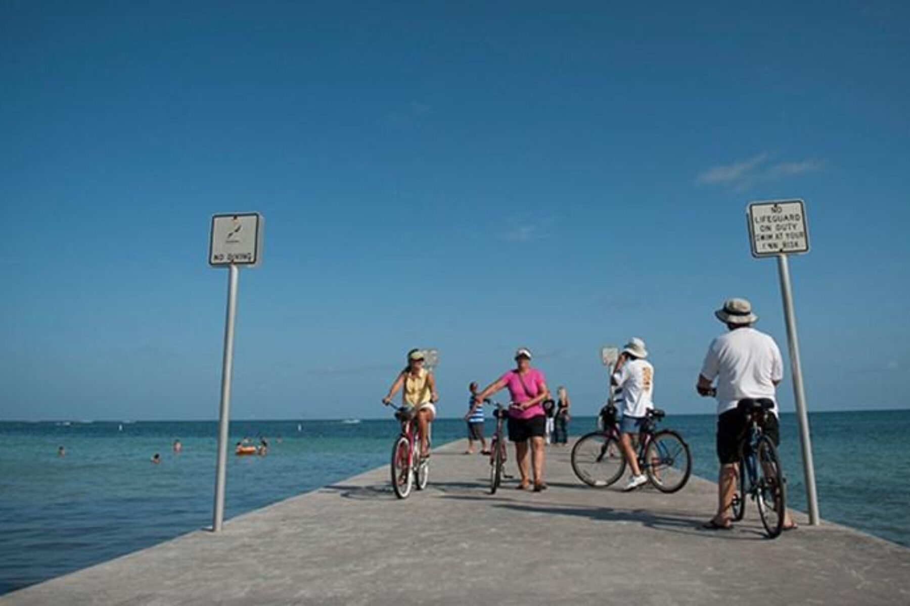
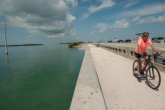
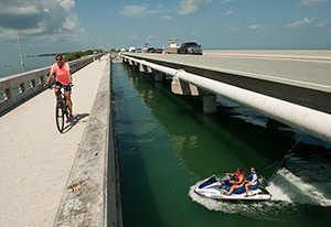
We divide our excursion into four 50-mile days, biking from Key Largo to Marathon, Marathon to Key West, and back. The biking is easy, for the most part, with the arching bridges presenting the only hills. The tourist-friendly islanders often wave us across intersections while they wait in traffic. And we never feel unsafe as we ride the 8-foot shoulders on the highway bridges—even on the famous Seven-Mile Bridge between Marathon and Little Duck Key.
Like the highway it parallels—sometimes nearly side by side, sometimes separated by greenway—the trail passes through the heart of every island town from Key Largo to Islamorada, Marathon, Big Pine and Key West. There’s convenient access to services everywhere—from bathrooms and bike shops to resort hotels and the ubiquitous open-air tiki bars, which make wonderful, shady places to stop for lunch or a cool drink. In other words, this is not a bike trip for someone who wants to get away from it all.
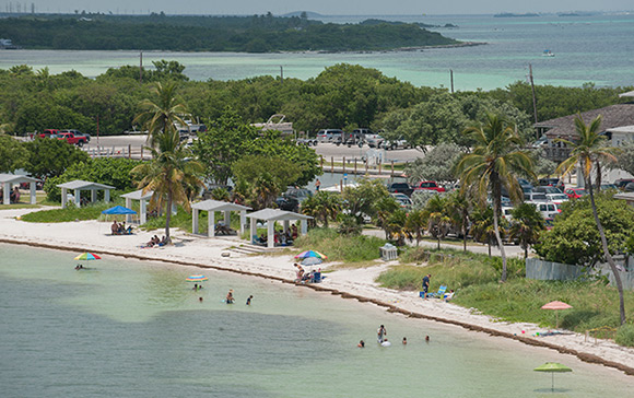
That being said, several portions of the FKOHT run through lush, park-like areas, and the trail provides access to a host of beautiful parks and beaches. The bridges offer spectacular views of what remains the Keys’ best feature—a sparkling landscape of ocean, small atolls and charming harbor areas. The old railway bridges add poignant glimpses of the Keys’ colorful past.
One of the best places to view and learn about the historic bridges and their railroad heritage is at the old Seven-Mile Bridge just south of the town of Marathon. The old bridge—located parallel to the new Seven-Mile (Highway 1) Bridge—no longer crosses the entire distance between Marathon and the Lower Keys, but the remaining portion is open for bike and foot traffic to Pigeon Key, a small island (also accessible by a ferry from Marathon) with a museum telling the history of the East Coast Railway.
About 10 miles farther south is Bahia Honda State Park, another lovely spot for viewing Keys history up-close. Known for its picturesque beaches, Bahia Honda also offers access to one of the best preserved of the old Flagler railway trestle bridges.
While we lap up the Keys’ charms, we find that riding the trail in its present state of development [J: better?] presents two challenges: lack of signage and tire-busting rubbish. Trail users are well served to visit the FKOHT page on the Florida State Parks website (www.floridastateparks.org) to download the latest route map and tip sheets. In time, that won’t be necessary, says Smith. “We’re working on signage and a consolidated way-finding system for the Scenic Highway that will direct you to points of interest like scenic vistas, boat ramps and the Dolphin Research Center. We’re also adding signs specific to trail sections. As we build, we see additional enhancements that are needed, like pedestrian crossing lights.”
We also experience several flat tires along the route. That’s always a hazard for skinny-tired bikes carrying panniers, but it’s especially prevalent on the FKOHT currently, due to bits of debris near construction sites and along the bridges. We carry spare tubes, but make frequent stops at local bike shops to shore up our supply.
Stopping Points
During our stop at the Backcountry Cowboy in Islamorada, a steady stream of bikers comes through to rent bikes and shop for supplies. Owners J.C. Mikula and Kristi Holman say the evolving trail was one reason they decided to add bike rental, repair and sales to their repertoire of kayaks and outdoor apparel a few years ago.
In a bid to keep busy during the off-season, Backcountry Cowboy has latched on to the Keys’ largest organized ride, BubbaFest, which draws some 200 riders each November for a week of riding and touring. Backcountry Cowboy provides bike rentals and “sag” service, as well as a trail oasis where bikers congregate throughout the week. “Last year we also provided kayaks for 80 people on their day off from riding,” Mikula adds. “Everybody that comes here riding the trail stops in at the restaurants and little retail stores, so it really has an impact.”
Down the road at Overseas Outfitters in Marathon, owner Jeremy Patterson is also enthusiastic about the trail. “We’ve seen a steady increase in the population of cyclists,” he says. Riders are sometimes surprised that the trail “almost disappears” once it enters the towns, where the trail and the sidewalks are largely the same, Patterson notes. “But the trail people have done an outstanding job of upgrading the trail significantly throughout the Upper and Lower Keys. It’s nice and wide and meanders away from Highway 1 in places.”
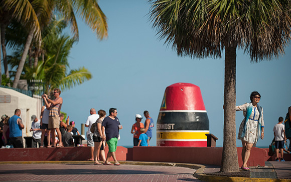
After cruising on the Highway 1 shoulder for 10 miles through the Lower Keys, where the trail has yet to be completed, we’re happy to roll into Baby’s Coffee, “the southernmost coffee roaster in America,” for a helping of Baby’s signature frozen java. Located 15 miles north of Key West, Baby’s has become a popular turnaround point for weekend bike groups. From there, we ride a section of nearly finished trail all the way into Key West, a busy tourist destination where bikes and cars manage a mostly peaceful coexistence.
The Long Haul
With Florida’s siren call of warm weather, ocean beaches and great seafood, it’s not hard to see the appeal of a network of paved pathways for non-motorized transport around the state. “It’s an exciting time to be into trails,” says RTC’s Bryan. “A lot of pieces are coming together with individual trails from around the state becoming part of a regional and state system.”
A recent study by the East Central Florida Regional Planning Council shows that three trails in Orange County (Little Econ, West Orange and Cady Way) yielded an economic benefit to the county of $42.6 million in one year (2010) and supported 516 jobs. Although that wasn’t enough to prevent Governor Rick Scott from line-item vetoing the $50 million allocation needed to complete the highly anticipated 275-mile Coast to Coast Connector [J: ok?] from St. Petersburg to Titusville, Bryan remains undaunted.
“We’re moving forward with a robust conversation about trails in the state,” he says. With 200 miles of the east-west passageway already built, he is working with the trails community and the Florida DOT to identify and combine other possible sources of funding.
Another major project—an 8-mile, 12-foot-wide bike and pedestrian trail along the south side of the Courtney Campbell Parkway across Tampa Bay—will link major trail networks on both sides of the bay. And then there is All Aboard Florida, a high-speed rail line that a private developer plans to build from Orlando to Miami. “We’re proposing a rail-with-trail,” says Bryan, hopeful of piggybacking on the developer’s enormous investment in land through a major north-south swath of the state to build another extensive trail.
Is it feasible? “It’s the hard ones that I like most,” says Bryan. “Right now we’re going through the seven ‘no’s’ to get to ‘yes.'” Henry Flagler would understand.
More Information
The Florida Keys Overseas Heritage Trail is a work in progress. Before you go, get the latest information about the trail route and points of interest by visiting the trail info page on TrailLink.com or the Florida State Parks website.
Several Key West communities have visitor information centers. A good starting point is the “official” Florida Keys Visitor Center in Key Largo (MM106.2), where helpful advice, maps and brochures—including the latest FKOHT map—are available.
Name: Florida Keys Overseas Heritage Trail
Length: 106.5 miles
Trail end points: Key Largo (MM 106 on US 1) to Key West (MM 0 on US 1)
Trail surface: Asphalt


Donate
Everyone deserves access to safe ways to walk, bike, and be active outdoors.
Related
View All
Elements of Gold: Michigan’s Pere Marquette Rail-Trail Is a Special Place for All Seasons
Special Olympics Promotes Exploration, Fitness and Discovery on Kansas Trails