5 Amazing Rail-Trail Destinations for Your Bucket List

This destination article was originally published in the Spring/Summer 2016 issue of Rails to Trails magazine and titled “Destination: America’s Next Top Rail-Trail.” It’s been published here in an edited format.
Rio Grande Trail (Colorado)
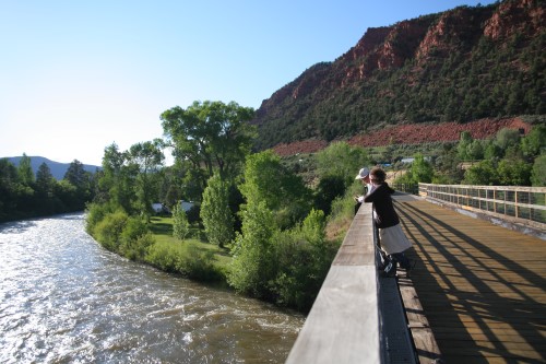
The Rio Grande Trail is quintessential Colorado, featuring a sparkling river, rustling aspens and scented pines against a backdrop of towering mountains. Even better, this bounty of beauty is easily accessible, with several communities dotting the route and a relatively gentle slope (no more than 4 percent) running downhill from the famed ski town of Aspen to Glenwood Springs. At 42 miles, nearly all paved, it’s the longest rail-trail in the state and, if it wins the competition, would take a proud place as the first trail from Colorado to enter the Hall of Fame.
For much of its length, the trail closely parallels the Roaring Fork River, and animals can often be spotted along the riverbank. It’s common to see deer, elk, heron and bald eagles; you may even spot a black bear or mountain lion. In winter, the river valley provides a critical range for deer and elk, so a small trail section between Basalt and Carbondale is closed from November to April; during those months this section is rerouted to the road.
For a bite to eat, a not-to-miss stop along the trail is the quirky and lively Woody Creek Tavern, located in the town made famous for being the residence of the late American writer Hunter S. Thompson. History buffs will want to visit the Glenwood Railroad Museum, which showcases railroad artifacts, old photographs and a large-scale model railroad. Just a half-mile from the trail’s western end, the museum is housed in the Glenwood Springs station, built in 1904 and still serving Amtrak trains.
GETTING THERE
Fly in to Aspen/Pitkin County Airport (ASE) (Sardy Field), roughly 3 miles from downtown Aspen and the eastern end of the trail. You can also get there by train; Amtrak makes regular stops at the Glenwood Springs station (413 Seventh St.). The Rio Grande Trail can be accessed from several places along its route; the Roaring Fork Transportation Authority (RFTA) website features a detailed map with parking locations.
RFTA also provides bus service to several key communities along the trail: Aspen, Snowmass Village, Basalt, Carbondale and Glenwood Springs. Many of these stops are within a half-mile of the trail. The buses are equipped with bike racks, and there’s a surcharge of $2 to take bikes aboard.
Bike Rentals
At either end of the trail, there are numerous options for bike rentals; you can find online listings of outfitters for both Aspen and Glenwood Springs. Mid-trail in Carbondale, Ajax Bike and Sports Bicycle Shop (571 Highway 133; 970.963.0128) and Aloha Mountain Cyclery (580 Highway 133; 970.963.2500) offer bike rentals, too.
One-way bike rentals with a shuttle ride back are especially popular in the area; here are some outfitters in Glenwood Springs that offer this service: Sunlight Mountain Resort (309 Ninth St.; 970.945.9425), Colorado Adventure Center (located in Glenwood Canyon Resort; 800.808.0357), Glenwood Adventure Co. (723 Cooper Ave.; 877.346.4536) and Canyon Bikes (319 Sixth St.; 877.945.6605).
More Info
Roaring Fork Transportation Authority website
Shelby Farms Greenline (Tennessee)

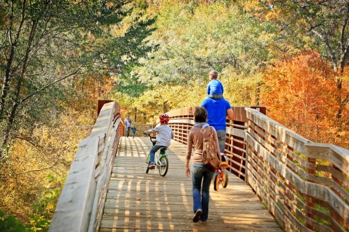
Family outings don’t come much better than excursions on the Shelby Farms Greenline, which offers an easy bike ride or walk on a paved, level route that begins in midtown Memphis and heads nearly 7 miles eastward. The trail is shady and quiet, with a wide, unpaved shoulder on each side. Since opening in 2010, the popular pathway, which sees as many as 200,000 users annually, has helped inspire a new culture of biking and walking in Memphis.
Anchored by Shelby Farms Park, the Greenline provides a unique connection to nature for city dwellers. One of the largest urban parks in the country, Shelby Farms spans a whopping 4,500 acres and abounds in woodlands, wetlands and lakes. The park even contains a herd of buffalo! The young and young at heart will enjoy its immense and whimsical Woodland Discovery Playground, horseback riding stables, disc golf and zip-lining courses, watercraft rentals and hiking trails.
Building on the positive momentum of the Greenline, Shelby County and Shelby Farms Park Conservancy broke ground last summer on a 4-mile eastward extension of the trail. Once it reaches the former railroad depot in Cordova (expected to happen in fall 2016), the corridor will cover 10.5 miles, making it the longest rail-trail in the state. If added to the Rail-Trail Hall of Fame, it also will be noteworthy as the first rail-trail in Tennessee to make the list.
GETTING THERE

Memphis International Airport (MEM) is less than 20 miles from the trail. The Greenline is accessible from multiple points, but many visitors will want to start on its east end in Shelby Farms Park (500 N. Pine Lake Drive). To get to the park from the west: Take Interstate 240 to the Walnut Grove exit and go east to the third stoplight. The park is on both sides of the road. Turn left at the light. From the east: Follow Walnut Grove or Mullins Station Road until you see signs for the park.
Bike Rental
Bikes are available seasonally from Shelby Farms Park (the rental facility is located at Mullins Station Road and Farm Road; 901.493.4799). Near the University of Memphis campus, bike rentals are available from Peddler Bike Shop (3548 Walker Ave.; 901.327.4833), about 2 miles south of the trail. Farther afield, another option is Midtown Bike (517 S. Main St.; 901.522.9757).
More Info
Shelby Farms Park Conservancy website
RELATED: 10 Rail-Trails That Helped Build the Movement
Hudson Valley Trail Network (New York)

Offering an unforgettable experience of beauty, adventure and charm, the Hudson Valley Trail Network encompasses the Walkway Over the Hudson, Hudson Valley Rail Trail and William R. Steinhaus Dutchess Rail Trail.
The magnificent Walkway Over the Hudson provides a journey through the sky. The longest elevated pedestrian bridge in the world, it spans just over a mile across the Hudson River and yields dramatic views of the river more than 200 feet below and of the surrounding New York countryside.
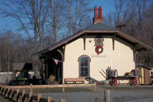
A glass-walled elevator takes visitors on a 70-second ride back to the ground, where they can catch the Dutchess Rail Trail on the river’s east bank. The trail winds through Poughkeepsie and continues southeast for 13 miles, ending at the restored Hopewell Depot, which serves as a visitor center and museum. A unique feature of the trail is its Military Mile, honoring the five branches of the U.S. military—Air Force, Army, Coast Guard, Navy and Marines—through special signage.
On the Walkway’s west side, travelers will find the quaint hamlet of Highland, with its charming shops and eateries. From there, the Hudson Valley Rail Trail heads northwest through hardwood forests and rock cuts and under two picturesque stone-arch bridges. After nearly 4 miles, it ends in the town of Lloyd. Two cabooses along the route, one dating from 1915 and the other from 1926 (this one housing historical exhibits), present a tangible connection to the trail’s railroad past.
Together, the three rail-trails, totaling 18 paved miles, provide an easy and spectacular way to experience the Hudson Valley.
GETTING THERE
The Hudson Valley trails are about a two-hour drive from New York City. They also can be reached by train; take Amtrak or a Metro-North train (the Hudson Line) from Grand Central Station in Manhattan to Poughkeepsie. The Walkway Over the Hudson is a few blocks from the station (about a 15-minute walk). If flying in, the closest major airport is Stewart International Airport (SWF) in Newburgh, about 25 miles from the trail system.
Bike Rentals
In Poughkeepsie, visit Leisure Ride Bike Rental (266 Titusville Road; 845.486.8125). Another option, in Wappingers Falls, is Wheel and Heel (2658 E. Main St.; 845.632.3050), about 5 miles from the southern end of the Dutchess Rail Trail.
More Info
- Walkway Over the Hudson website
- Hudson Valley Rail Trail website
- Dutchess County website
GHS Swamp Rabbit Trail (South Carolina)

In the backyard of two major Southern cities, Atlanta and Charlotte, N.C., Greenville’s Swamp Rabbit Trail is an easily accessible treasure in the foothills of the Blue Ridge Mountains. Following the course of the scenic Reedy River, the paved pathway covers nearly 20 miles, including passage through the beautiful campus of Furman University.
With a relatively flat surface, safe and pleasant environment, and numerous neighborhood connections, the trail provides a convenient way for people of all ages and abilities to exercise, a point encouraged and promoted by its primary corporate sponsor, the Greenville Health System. Highlights of the corridor include the spectacular waterfalls of Greenville’s Falls Park, a pair of fighter jets displayed in Cleveland Park, and the wildlife-abundant forests and wetlands of Lake Conestee Nature Park.
Since opening in 2009, the trail has kept business hopping in the two towns it connects, Greenville and Travelers Rest. With 500,000 users annually, the trail is the most-used recreational asset in Greenville County. It has spurred the opening of more than 40 new businesses, some with nods to the thriving biking culture via such names as Swamp Rabbit Café and Grocery, Swamp Rabbit Brewery & Taproom and Tandem Crêperie & Coffeehouse . If picked for the Rail-Trail Hall of Fame, this successful community connector would be the first trail in South Carolina to achieve such an honor.
GETTING THERE
The trail is about a two-hour drive from Atlanta and Charlotte. Greenville-Spartanburg International Airport (GSP) is about 14 miles from the trail. Amtrak’s Greenville Station (1120 W. Washington St.) is only about a half mile from the Swamp Rabbit. Drivers will find no shortage of parking in the numerous parks along the route, and the trail is easy to reach from Highway 276, which it loosely parallels.
Bike Rentals
Bikes can be rented at both ends of the trail. In Greenville, rentals are available from Reedy Rides (12 W. McBee Ave.; 864.419.2944), Bike the Rabbit (1021 S. Main St.; 888.690.8244) and the Swamp Rabbit Inn (1 Logan St.; 864.517.4617). In Travelers Rest, Sunrift Adventures (1 Center St.; 864.834.3019) rents bikes.
More Info
Greenville County Parks, Recreation & Tourism website
Banks-Vernonia State Trail (Oregon)
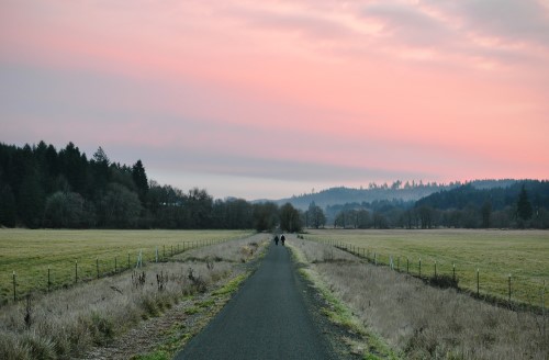
A thread of black in an emerald blanket, the Banks-Vernonia State Trail weaves its way between two peaceful towns in the foothills of northwest Oregon’s Coast Range, less than an hour’s drive from Portland. Most of the 22-mile paved pathway is enveloped by the tall trees that attracted the lumber industry in the early 1900s—a verdant mix of Douglas fir, maple, cedar and alder.
At its northern end, you’ll find the Vernonia Pioneer Museum, which tells the story of that lumber history. The town, no longer revolving around the large mill that once thrived here, is reinventing itself as a destination for outdoor enthusiasts. Visitors will find charming restaurants, coffee shops, bed-and-breakfasts and an art gallery downtown.
Although more of a country cousin, Banks, at the other end of the trail, sees its share of tourists too. Here, the trail’s first few miles offer a contrasting openness, as farm fields in subdued earth tones unfurl under a canopy of clouds. This fertile landscape—the Tualatin Valley—is well known for its wine, especially pinot noir. Find a list of local vineyards online to plan a wheels and wine vacation.
Mid-trail, visitors will cross L.L. Stub Stewart State Park. A variety of recreational amenities and camping options (tent sites, rustic cabins, RV hookups) in a postcard-perfect setting make this 1,800-acre park immensely popular.
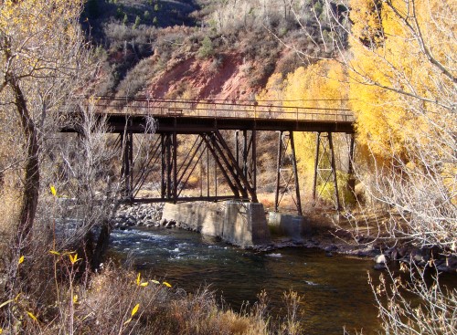
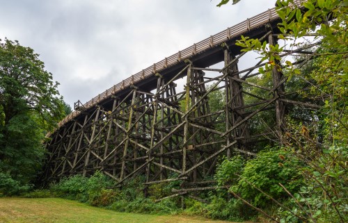
Another highlight of the route is the Buxton Trestle, spanning 735 feet and curved so you can’t see the other end from the start. Rising 80 feet above Mendenhall Creek, this railroad relic is an impressive sight from above or below. A dozen other trestles dot the route as well.
GETTING THERE
Portland is about a 45-minute drive away. The closest major airport is Portland International Airport (PDX). The trail has six trailheads with parking between Banks and Vernonia: Banks, Manning, Buxton, Tophill, Beaver Creek and Vernonia.
Bike Rentals
Banks Bicycles (14175 N.W. Sellers Road; 503.680.3269), adjacent to the Banks trailhead, offers bicycle, tandem and bike trailer rentals on an hourly and daily basis.
More Information


Donate
Everyone deserves access to safe ways to walk, bike, and be active outdoors.


