Top 10 Trails in Virginia
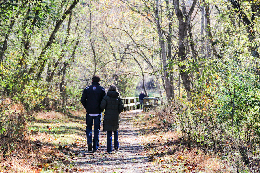
The Old Dominion is truly a Commonwealth—of trails, that is, with some 49 connecting some of the country’s most renowned geographic and cultural landmarks, and 11 more on the way. Here are just some of the reasons why we think Virginia trails are truly top-notch.
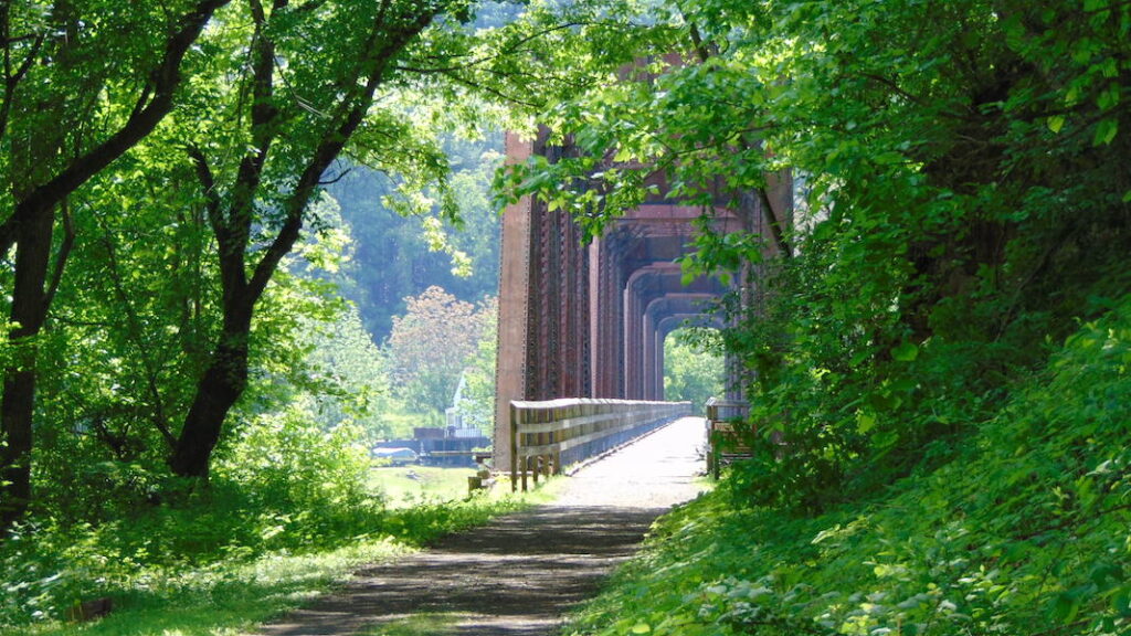
Virginia Creeper National Recreation Trail
Counties: Grayson, Washington
Running for 34 miles through the Appalachian foothills in southwest Virginia, the Virginia Creeper Trail is a bucket-list destination for trail users on wheels, heels and horseback, as well as a major economic engine for the region. Along the route—which starts in Abingdon and meanders eastward through Damascus to Whitetop Mountain in the Mount Rogers National Recreation Area—this Rail-Trail Hall of Famer has a plethora of offerings for trails users: spectacular scenery (think farmland, forests, streams and wildlife); historic small towns with bike shops, food, wine, nightlife and sightseeing; and relics from the bygone days of railroads—including 47 surviving trestles and an original depot building-turned-visitor center/gift shop (Damascus).
Highlight: In Abingdon and Damascus, shuttle services are available to ride bicyclists up to Whitetop Station for an easy 17-mile glide back down to Damascus, or a full additional 17 miles to Abingdon (very slight grade).
- RELATED: Appalachian Engine: The Virginia Creeper Trail Keeps Bringing Visitors Back
- TRAIL OF THE MONTH: Virginia Creeper National Recreation Trail (May 2013)
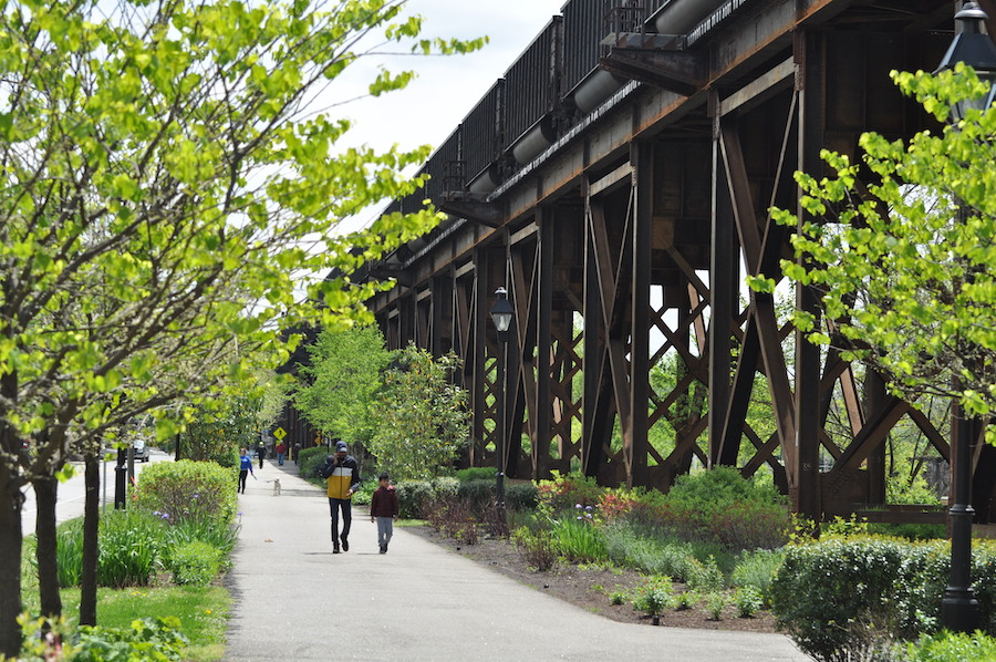
Washington and Old Dominion Railroad Regional Park
Counties: Arlington, Fairfax, Loudoun
More widely known as the W&OD Trail for short, this well-maintained, 45-mile asphalt trail—also an inductee into the Rail-Trail Hall of Fame—is a premier commuting and recreation corridor for the Northern Virginia/greater D.C. area. The route is well marked with 0.5-mile posts and is dotted with tourist-friendly areas and communities, from Purcellville wine country and historic Leesburg in the northwest, to the commercial areas of Dunn Loring, Falls Church and Arlington in the east. Though water fountains can be sparse, trail users are never far away from shops and services as they traverse woodsy, rural, suburban and urban landscapes. Note: Road crossings exist along the route; be sure to stay alert and obey all trail/traffic signage.
The W&OD also offers connections to the Four Mile Run Trail (Shirlington), the Bluemont Junction Trail (Arlington), the Custis Trail (Arlington), which connects to the Mount Vernon Trail heading south to Alexandria, and the Meadowlark Connector Trail (to Meadowlark Botanical Gardens in Vienna) and is also a key segment of the developing 800-mile Capital Trails Coalition network in Virginia, Maryland and Washington, D.C.
Virginia Capital Trail
Counties: Charles City, Henrico, James City, Richmond City
The Virginia Capital Trail is a corridor rich with 400+ years of recorded history along its route connecting “three” state capitals. Mile zero begins just outside of Jamestown—established as the first permanent English colony in 1607—and less than 10 miles from another historic capital, Williamsburg, breeding ground of the American Revolution. Over its 55 mile route, the trail passes Revolutionary War battlegrounds, wetlands, parks, open space and historic sites, including the homestead of President John Tyler. Just on the other side of trail’s end at Richmond’s floodwall, the Canal Walk takes visitors to Tredegar Iron Works—one of 13 battlefields/sites comprising Richmond National Battlefield Park—and the American Civil War Museum, chronicle the country’s deadliest conflict.
It’s easy to see why this trail is the second-most-visited attraction in the Richmond Region; in 2020, the Virginia Capital Trail Foundation recorded more than 1.2 million trail uses!

Dahlgren Railroad Heritage Trail
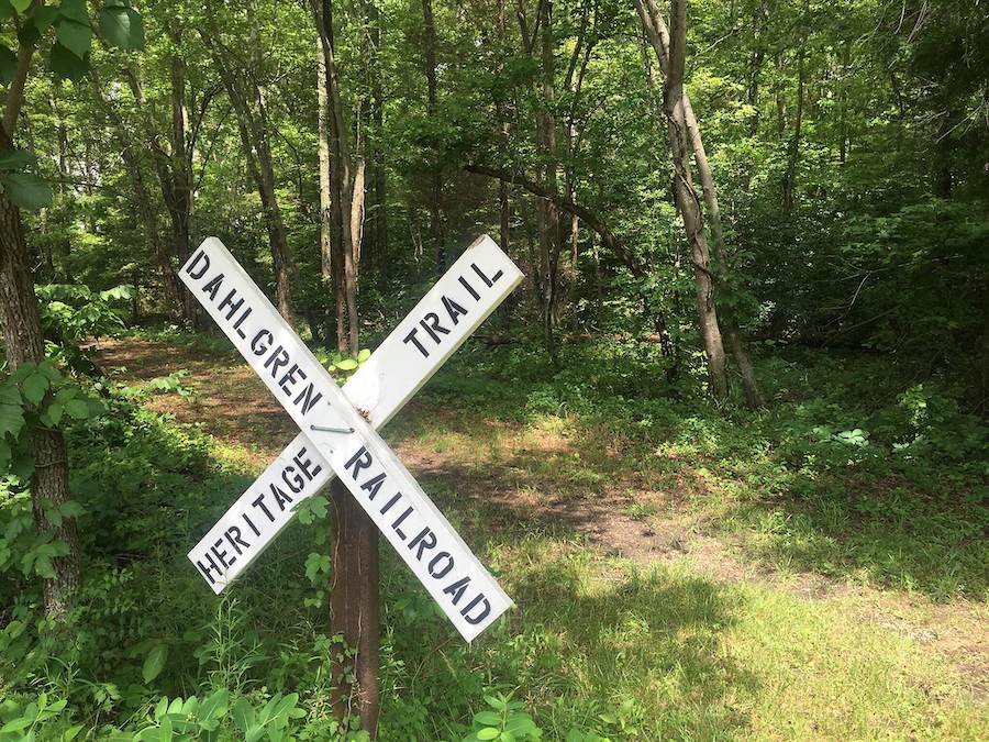
County: King George
This recent 16-ish-mile addition to the King George County park system has a unique history in that it is maintained by Friends of the Dahlgren Railroad Heritage Trail but privately owned by long-time trail advocate David Brickley, who was instrumental in saving the corridor. The rustic route stretches almost across King George County on the former Dahlgren Branch Line—an important rail line during World War II—showcasing the wildlife and natural beauty of the region along the way. The trail was designated a National Recreation Trail and is part of the developing Potomac Heritage National Scenic Trail network, which connects the mouth of the Potomac River at the Chesapeake Bay to the Allegheny Highlands of Pennsylvania. Note that the dirt route is most appropriate for hiking and mountain biking.
Chessie Nature Trail
County: Rockbridge
This 7-mile winding dirt and gravel trail travels through the beautiful Shenandoah Valley region along a former piece of the Chesapeake & Ohio Railway. Managed by the Virginia Military Institute, the trail route—which mostly follows the winding Maury River—features birds, mammals and cattle, some unfenced, grazing in adjacent meadows. (Note: You may come across cattle gates that can be tricky to get around.) In the northeast, Lexington—a city well known for its views, universities and history—serves as the trail’s home base; here you’ll find the military institute, Washington and Lee University, Stonewall Jackson’s house and Oak Grove Cemetery. Enjoy the stunning steep cliff views in the last mile to charming Buena Vista, which is home to Southern Virginia University and provides many opportunities for shopping and outdoor recreation.
Blue Ridge Tunnel Trail
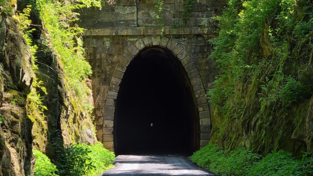
Counties: Augusta, Nelson
“Although only 2.25 miles long, the Blue Ridge Tunnel Trail has plenty of wow factor,” wrote Laura Stark in a December 2020 TrailBlog article. Opened in November after nearly 20 years of effort, the crushed-stone rail-trail passes through a 4,273-foot tunnel bored through the Blue Ridge Mountains (it’s 700 feet below the surface at its lowest point) of central Virginia in the mid-1850s. (Note that if you enter the tunnel in Waynesboro, be prepared for a 19% grade in one section!) This trail project is so cool it won a Coalition for Recreational Trails Annual Achievement Award 2020. Also, the trail is nearby to several outdoor destinations, including Shenandoah National Park and the Appalachian Trail, just to name a few.

View a recently released documentary by American Focus, Inc., on the history of the Blue Ridge Tunnel.
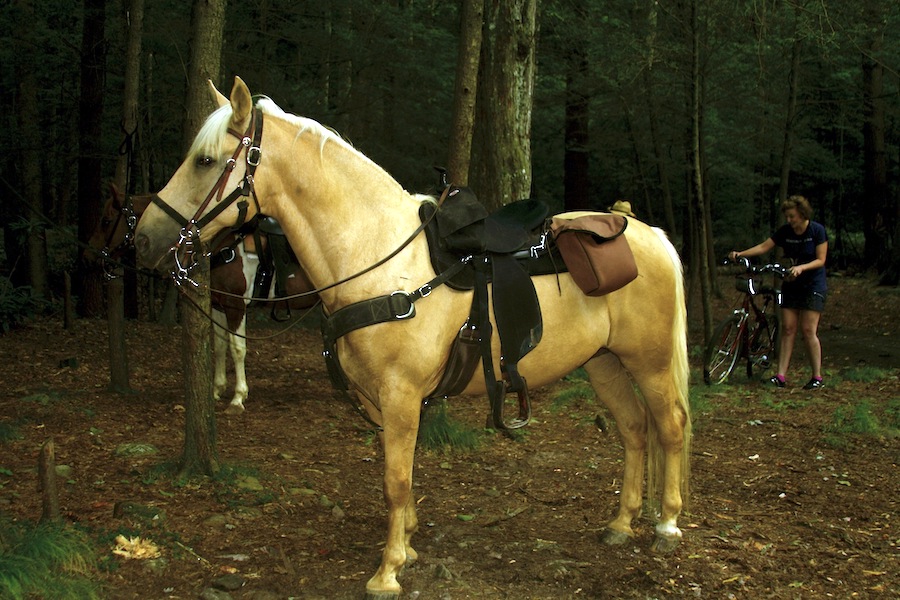
New River Trail State Park
Counties: Carroll, Grayson, Pulaski, Wythe
Traveling for 57 miles through lush tree canopy in Virginia’s Blue Ridge Mountains, the New River Trail State Park is one of the state’s premier rail-trails and a National Recreation Trail to boot. Along its low-grade crushed-stone route, which follows its namesake river—one of the world’s oldest—for much of the way between Pulaski and its endpoints at Galax and Fries, there are abundant of opportunities to bike, walk, cross-country ski, horseback ride and engage in numerous water sports, from canoeing and kayaking to tubing. The route also includes trestles (including the 950-foot Hiawassee trestle near mile 8), two cavernous, dark tunnels, dams, the historical Shot Tower and numerous post-trail amenities in Galax and Pulaski.
TRAIL OF THE MONTH: Virginia’s New River Trail State Park (July 2015)
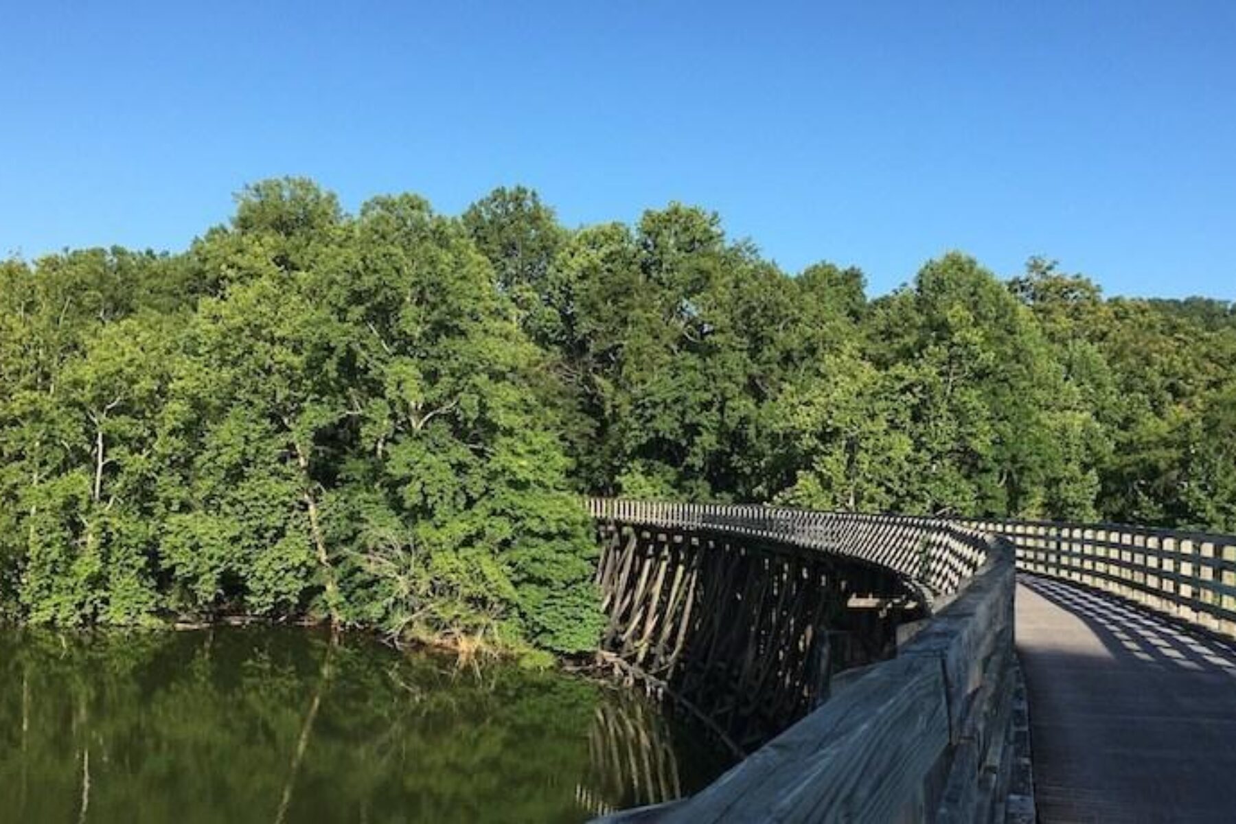
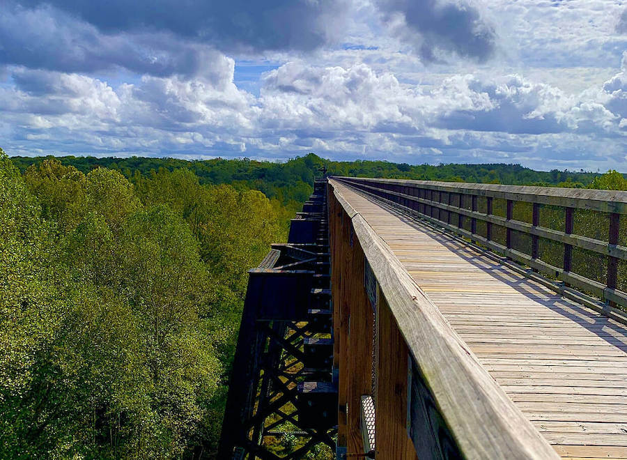
High Bridge Trail State Park
Counties: Cumberland, Nottoway, Prince Edward
The namesake feature of this 32-mile finely crushed limestone trail is an unforgettable experience that towers 125 feet above the mighty Appomattox River and nearly a half-mile (2,440 feet) across it. With origins stretching back to the Civil War, the Virginia Historic Landmark—which is also included in the National Register of Historic Places—is the longest recreational bridge in Virginia and one of the longest in the United States. The trail offers unparalleled views of the Central Virginia Countryside and is accessible (about an hour’s drive) from both Lynchburg and Richmond.
On its west end, about 12 miles takes you to historic Appomattox and the famed Appomattox Court House, where General Lee surrendered during the Civil War. The trail’s surface is best suited for hybrids and mountain bikes, and horseback riding is permitted. (Be sure to pack drinking water, as public fountains are not available.)
Elizabeth River Trail

County: Norfolk
We absolutely had to include this 10.5-mile trail in Norfolk on our list, which connects Harbor Park to the Norfolk International Terminals. The iconic, culture-packed trail provides connections to an impressive variety of major destinations as well, like Norfolk State University, Old Dominion University, the Downtown Waterfront (including Waterside Marina, Town Point Park and the Nauticus—a marine-themed science center featuring the Battleship Wisconsin) and Fort Norfolk, which was authorized by George Washington in 1794. The route also provides access to numerous scenic, eclectic and residential areas, including Freemason, one of the city’s oldest neighborhoods. The area has a sea-faring history; along the waterfront you’ll see ships and barges, navy vessels and tankers, as well as plenty of species of waterfowl.
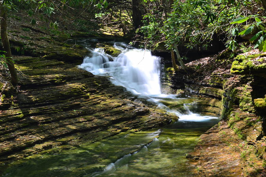
Devil’s Fork Loop Trail
County: Scott
The remote 7-mile Devil’s Fork rail-trail boasts amazing rock formations, hemlock and rhododendron coverage, waterfalls, mountain views, and swimming and fishing holes along a natural dirt path, with the main attraction being the emerald-pooled Devil’s Bathtub (1.5 miles from the trailhead). Another must see: a 50-foot waterfall at the mouth of Corder Hollow, just a little further ahead. For all these reasons, the trail is one of the most popular in Virginia.
But hikers, take note: A 1,200-foot elevation change, 18 stream crossings (some slippery), a slightly tricky route (a compass and map are a must) and a lack of nearby facilities (be sure to take water!) mean that those who tackle the trail should be prepared for the challenge ahead.
NOTE: As of a few years ago, there were only 14 parking spaces (via the U.S. Forest Service) presently serving this trail. All other property around the trail is private, and access to the trail is permitted through an easement with a private landowner. Please be courteous and respectful to all adjacent landowners (do not park on private property, trespass or block local access routes), and if you get to the trail and find there’s no parking available, be sure you are equipped with information on other great local spots to try. The local county recommends visiting this trail on weekdays due to its weekend popularity. A great resource to locate other nearby options is TrailLink.com’s Virginia trails page. (Special thank you to Nancy Johnson for providing the parking and access information.)
National Scenic and Historic Trails in Virginia
Did you know? Virginia is a national trail haven—with in-house connections to six National Scenic and Historic Trails! Check out these historical and geographic heavy weights:
- Star-Spangled National Historic Trail (Chesapeake Bay region)
- Washington-Rochambeau Revolutionary Route National Historic Trail (covering nine states and Washington, D.C.)
- Potomac Heritage National Scenic Trail (Mouth of the Potomac River to the Allegheny Highlands in Pennsylvania)
- Appalachian National Scenic Trail (Georgia to Maine)
- Overmountain Victory National Historic Trail (Virginia, Tennessee, North and South Carolina)
- Captain John Smith Chesapeake National Historic Trail (the first national water trail!)
Read about some these incredible trails in our November 2019 TrailBlog article “The Great American Rail-Trail Experience: Connections to Our National Scenic and Historic Trails.”
Special acknowledgments: Kelly Pack, RTC Director of Trail Development; Laura Stark, lead writer and editor, Rails to Trails magazine; Marianne Wesley Fowler, RTC’s Senior Strategist for Policy Advocacy; Cat Anthony, Virginia Capital Trail Foundation


Donate
Everyone deserves access to safe ways to walk, bike, and be active outdoors.


