Making Connections on 2021’s New Rail-Trails
As we reflect back on 2021, one thing that many of us are grateful for are the trails in our lives that have brought us moments of solitude and peace, as well as togetherness with family and friends—playing a role in our daily routines and having a starring role in our special outings. With the growing clamor for these valued outdoor places, trail development in more and more communities has been coalescing into local, regional and even statewide trail systems, connecting more people to parks, schools, businesses, transit stations and all the places they need to go—bringing economic, health and social benefits on both an individual and broader level.
Below, we’ve spotlighted a handful of the exciting new rail-trails that have opened up around the country this year, as well as the broader trail networks they tie into.
Albany-Hudson Electric Trail (New York)
Winding 36 miles through New York’s Hudson River Valley, the Albany-Hudson Electric Trail is a stunner. From Rensselaer, a riverfront city east of Albany, the pathway follows a former electric trolley line skirting farmlands, orchards and sapphire-blue lakes to its southern end in Hudson. Along the way, travelers can visit a handful of charming communities in Rensselaer and Columbia counties, and enjoy picturesque stream crossings and trailside signage interpreting the history of the electric trolley that operated here from 1900–1929.
Key Connections: The Albany-Hudson Electric Trail is also part of the cross-state Empire State Trail spanning a whopping 750 miles with a north–south route from New York City to the Canadian border and an east–west component from Albany to Buffalo.
RELATED: 2020 Vision: New York’s “Empire State Trail” Is Making Trails a Main Attraction
Red Line Greenway (Ohio)
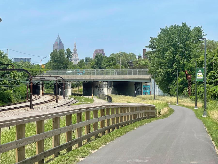
Opened this summer, the new Red Line Greenway in Ohio offers a 2-mile, paved pathway paralleling its namesake commuter rail line and connecting two RTA transit stations and eight Cleveland neighborhoods. As a major east–west connector, the rail-with-trail is a cornerstone of the Re-Connecting Cleveland project, an effort by Cleveland Metroparks to develop more interlinked trails and greenspace in the city while prioritizing equitable access to the outdoors.
As it makes its way from the Michael Zone Recreation Center Park to the Cuyahoga River, the greenway offers a pleasant respite in the city center with natural landscaping and native trees.
Key Connections: On its eastern end, the Red Line Greenway connects to the Cleveland Foundation Centennial Lake Link Trail, a developing rail-trail that will enhance access to Lake Erie from downtown. The greenway will also eventually tie into one of the region’s premier destinations, the Ohio & Erie Canal Towpath Trail, which begins in the heart of Cleveland and continues 80 miles to the south.
TRAIL OF THE MONTH: Ohio & Erie Canalway Towpath Trail (June 2016)
Southside Trail (Georgia)
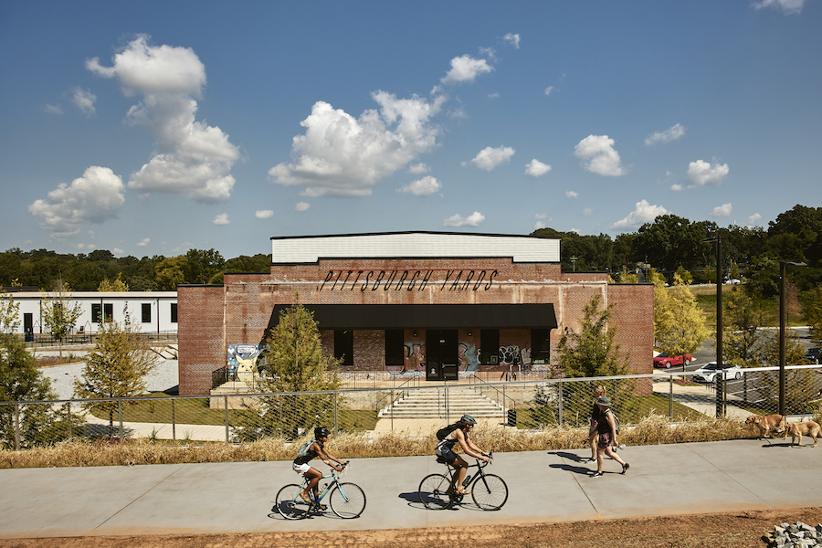
In Georgia’s capital, the ever-evolving Atlanta BeltLine is a rail-trail rockstar for both the state and the South. Since 2008, segments of the planned 22-mile multiuse loop have opened up in neighborhoods all across the city, including the West End, Northside, Eastside, Southwest, Westside—and now Southside. Connecting the neighborhoods of Oakland City and Glenwood Park, the 4-mile addition to the trail network provides a linkage between the Beltline’s Westside Trail and the Eastside Trail, creating a continuous pathway across a large swath of the metropolitan area.
Although most of this new route has an unimproved natural surface, a 0.8-mile concrete portion on the Southside Trail’s western tip (between University Avenue and the redeveloped Pittsburgh Yards site) opened in fall 2021. Paving for the remainder of the trail is anticipated to start next year and continue through 2025. In November, a $16.46 million RAISE grant was awarded to advance construction on the Southside Trail’s unpaved segments.
Key Connections: The Atlanta BeltLine—connecting dozens of neighborhoods, parks and mass transit stations—has proven to bring transformative economic, transportation and health benefits to residents. Speeding its development: The project received a major boost in March 2021 when the Atlanta City Council approved legislation creating a Special Service District that will provide approximately $100 million towards completion of the 22-mile loop, anticipated for 2030.
TRAIL OF THE MONTH: Georgia’s Atlanta Beltline (March 2014)
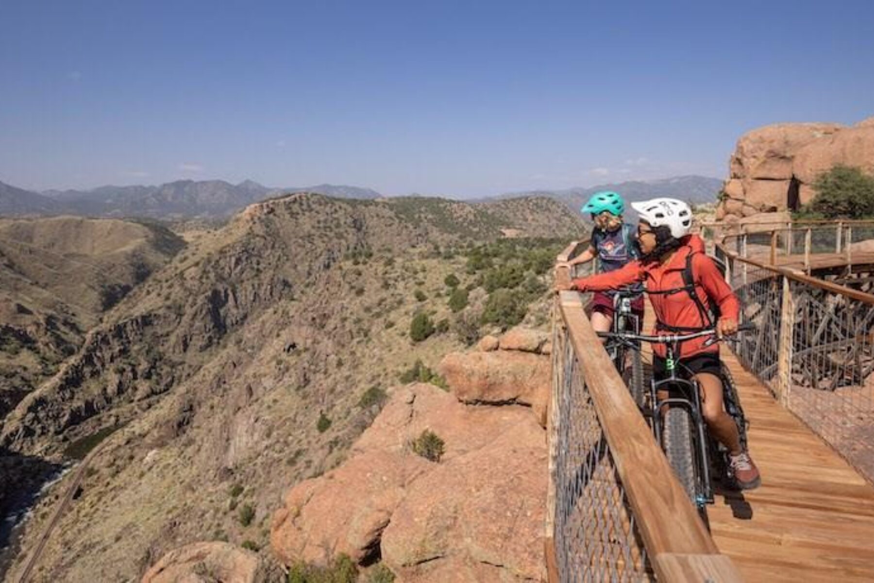
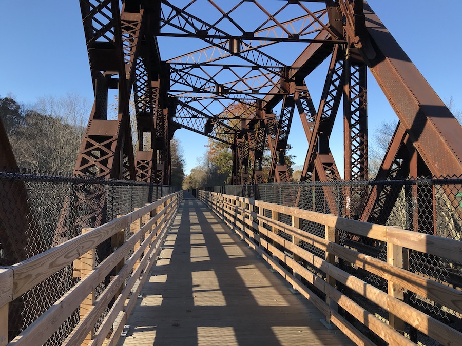
Point Alta Vista Trail (Colorado)
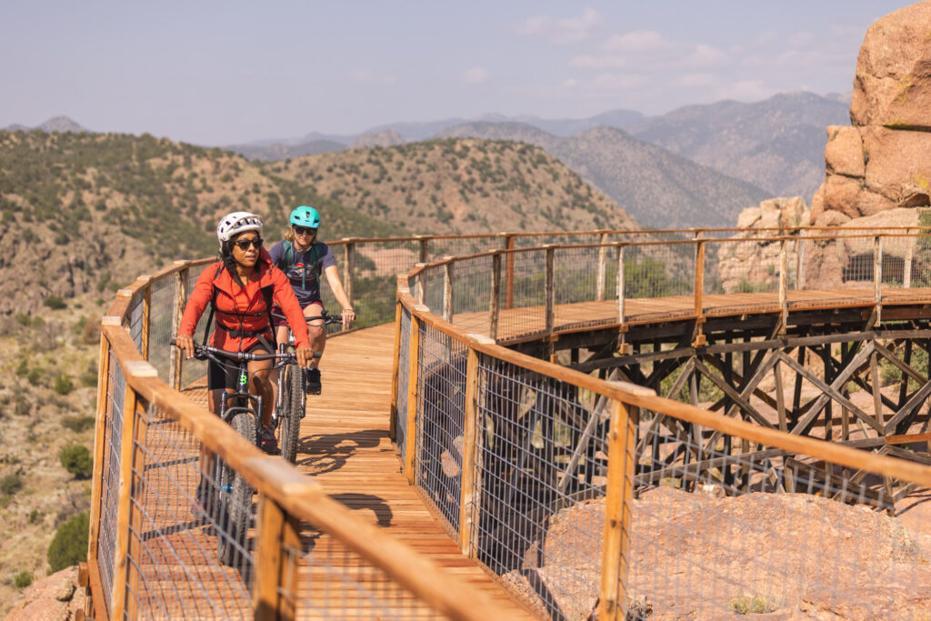
Just west of Cañon City, Colorado’s famed Royal Gorge Bridge and Park features an iconic landmark: one of the world’s highest bridges, rising 955 feet above the Arkansas River. In addition to jaw-dropping views, the ticketed park offers fun attractions, like an aerial gondola and a zip line that crosses the deep gorge. It’s surrounded by the 5,300-acre Royal Gorge Mountain Park, which is managed by Cañon City and free to the public.
Nearly 20 miles of hiking and mountain-biking trails can be found within the city’s park, including the new Point Alta Vista Trail, built on the former Royal Gorge Scenic Railway (not to be confused with the Royal Gorge Route Railroad, a popular dining-car line in the area). The corridor, which once ferried tourists on miniature trains from the Buckskin Joe Old West theme park (now closed) to the lip of the gorge, today serves as a milelong, natural-surfaced rail-trail with refurbished trestles and a scenic boardwalk overlook of the river, the Royal Gorge Bridge and the Sangre de Cristo Mountains.
Key Connections: From the Point Alta Vista Trail, outdoor enthusiasts can connect to the Royal Gorge Mountain Park’s more challenging singletrack trails for heart-pumping exercise and a thrilling adventure.
Museum Trail (Mississippi)
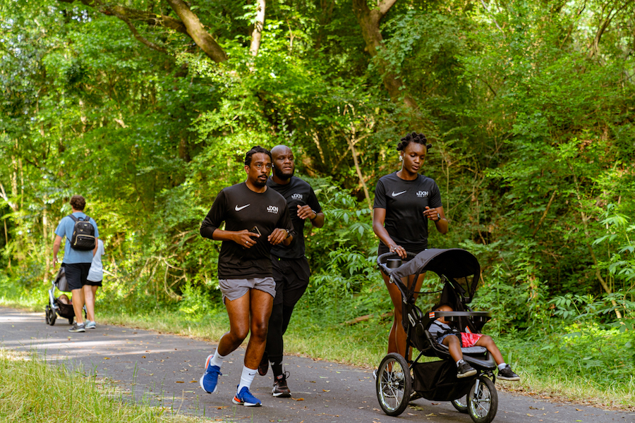
Jackson’s Museum Trail packs a lot into its 2.5 miles. Its northern end skirts the edges of LeFleur’s Bluff State Park, a 305-acre green expanse nestled against the Pearl River. On its way out of the park, the paved trail passes the Mississippi Children’s Museum and Mississippi Museum of Natural Science as it travels along the former Gulf, Mobile & Ohio Railroad corridor.
Continuing southwest, the pathway provides access to two more parks—Laurel Street Park and Belhaven Heights Park—and two more museums: the Mississippi Civil Rights Museum and the Museum of Mississippi History.
Key Connections: The rail-trail, Jackson’s first, is already proving to be a valued asset for the community, providing a safe transportation option connecting three of the city’s neighborhoods—Belhaven, Belhaven Heights and Lefleur East—with museums, parks and the Mississippi Farmers Market.
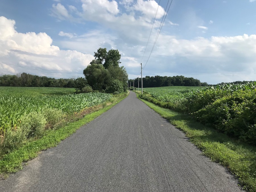
Maybrook Trailway (New York)
In southeastern New York, the Maybrook Trailway connects a handful of storied small towns (some dating back to the late 1700s) on a 24-mile route from the Connecticut border to Hopewell Junction. Traversing secluded woodlands, wildlife-rich wetlands, craggy rock cuts and pretty lake shorelines, the enticing rail-trail offers something to see around every bend. The paved pathway ends at the Hopewell Depot, circa 1873, which houses a museum and historical photo gallery.
(Note: The trail is fully complete except for a bridge on its southern end in Brewster; stairways on either side of the bridge are available for the detour. Construction on the bridge is expected to begin in April 2022 and completed by that fall.)
Key Connections: In Pawling, the Maybrook Trailway intersects the famed 2,200-mile Appalachian Trail. And, at the Hopewell Depot terminus, the trailway—a component of the larger Empire State Trail—joins the William R. Steinhaus Dutchess Rail Trail. The latter is part of the Hall of Fame trio of connected rail-trails spanning a collective 20+ paved miles that head up to Poughkeepsie, the Hudson River and beyond.
TRAIL OF THE MONTH: New York’s Hudson Valley Trail Network (March 2016)


Donate
Everyone deserves access to safe ways to walk, bike, and be active outdoors.


