Bay Area Trails Collaborative Footprint
San Francisco Bay Trail | Photo by Cindy Barks
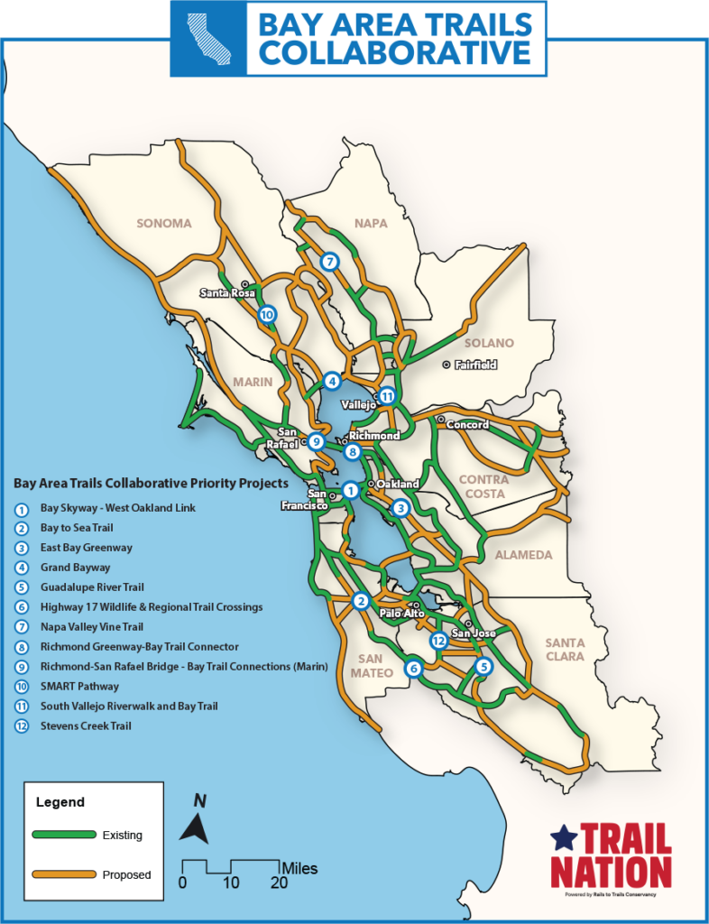
Trail Map
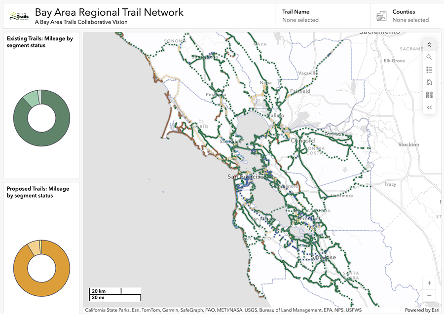
RTC, BATC’s Trail Development & Stewardship Working Group, and dozens of regional partners maintain the Bay Area Regional Trail Network map based on a variety of trail network criteria, existing trail and active transportation plans from around the region, and the expertise of local trail managers, planners, and advocates. The network map is intended to illustrate a connected and off-street and protected multi-use network.
Explore the interactive map and please leave any comments on the map using the public comment portal. Instructions can be found on a splash screen when you open the map.
Project Footprint
Enhancing Quality of Life in the Bay Area by Providing Equitable, Healthy Trail Access for People of All Ages and Abilities
Nearly 60 percent of the regional trail network is already built. The trail network’s overall footprint travels through nine counties and dozens of communities—urban and rural, small and large—in the San Francisco Bay Area. The network includes trail systems that are either complete or in development, such as the 500-mile San Francisco Bay Trail, which links the diverse communities along the Bay’s shoreline; the 550-mile Bay Area Ridge Trail, which connects the Bay Area along its ridgelines; the massive 1,200-mile California Coastal Trail, which spans the entire California coast; and the 47-mile Napa Valley Vine Trail, which winds through the vineyards of one of the most popular tourist destinations in the country.
Despite the popularity of the region’s existing trail systems, there are still major gaps to fill. Competition for transportation and park funding is fierce, and barriers exist in accessing these resources. By connecting multiple networks into a region-wide trail system, the Collaborative amplifies the benefits of existing infrastructure to transform the region’s walkability and bikeability, strengthen its economic development, implement social equity and reduce carbon dioxide emissions.
Get Involved
If you have questions about the Bay Area Trails Collaborative, or are interested in getting involved in the coalition’s work, please reach out to the Rails-to-Trails Conservancy’s Western Regional Office staff:
Western Regional Office
510.992.4662
Email Office
Iman Sylvain
Western Regional Director
510-992-4636
isylvain@railstotrails.org
Become a Member or Friend of the Bay Area Trails Collaborative! We offer two options to meet your desired level of involvement.
Become a BATC Member
Membership is open to interested organizations, agencies and businesses that support trails and the BATC mission. As a Member, you will be invited to help develop and implement the BATC strategic plan, serve on working groups and attend quarterly meetings. There is no cost to join.
All new Member applications are subject to review and approval by BATC leadership. More details—including the commitments and benefits of becoming a Member—are available on the application page.
Become a Friend of BATC
We invite all interested organizations, agencies, elected officials and individuals to show your support for the BATC vision and mission, and become a Friend of BATC. As a Friend, you will receive regular communications updates about the progress of the developing trail network and action alerts for advocacy opportunities in which your voice can truly help make a difference. Find out more details about Member benefits on the application page. There is no cost to join.
Why Your Support Matters to the Regional Trail Network
As a Member or Friend of BATC, you can help advocate for and advance the completion of a more than 2,600-mile regional trail network that, when developed, will connect people and places across the nine counties in the San Francisco Bay Area. Through this bold vision, we will enhance the quality of life in the region by creating more opportunities for recreation and active transportation—which will improve health and wellness across all communities, including those historically underserved and marginalized, reduce pollution and greenhouse gases and promote environmental sustainability.