Industrial Heartland Trails Coalition Footprint
Station Road Bridge in Brecksville along the Ohio & Erie Canal Towpath Trail | Photo by Richard T. (Tom) Bower
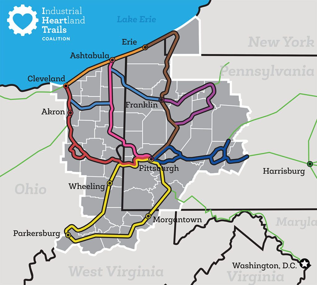
The Industrial Heartland Trails Coalition’s (IHTC’s) 1,500-mile-plus trail network will span 51 counties in Western Pennsylvania, northern West Virginia, eastern Ohio and the southwestern corner of New York.
When complete, the trail network—now 48 percent complete—will comprise the largest shared-use trail system in North America for tourism, physical activity and recreation. Currently, approximately 50 gaps totaling nearly 700 miles are all that need to be filled to complete this powerful trail vision. Although they comprise corridor segments that are challenging to complete due to issues such land acquisition, funding and engineering—many (75 percent) are 15 miles or less.
For example, the completion of four gaps (totaling only 4.1 miles) in the vicinity of Akron and Cleveland will result in 120.5 miles of continuous trail. And completing a 3-mile segment of trail at Oil Creek State Park in Pennsylvania along the Erie-to-Pittsburgh Trail would result in 66 continuous miles.
Explore the route on an interactive map of trails in the northeast region of the U.S., or download the network map.
Parkersburg to Pittsburgh Corridor
- North Bend Rail Trail – W.Va.
- Harrison North Rail Trail – W.Va.
- West Fork River Trail – W.Va.
- MCTrail – W.Va.
- Mon River Rail Trail – W.Va.
- Sheepskin Rail Trail – Pa.
- Three Rivers Heritage Trail – Pa.
- P2P Feasibility Study
Cleveland to Erie Corridor
- Cleveland Lakefront Trail – Ohio
- Great Lakes Seaway Trail – Pa.
Pittsburgh to Harrisburg Corridor
- Apollo’s Kiski Riverfront Trail – Pa.
- Roaring Run Trail – Pa.
- West Penn Trail – Pa.
- Ghost Town Trail – Pa.
- Path of the Flood Trail – Pa.
- Lower Trail – Pa.
Erie to Pittsburgh Corridor
- Great Lakes Seaway Trail – Pa.
- Chautauqua Rails to Trails – N.Y.
- Corry Junction Trail – Pa.
- East Branch Trail – Pa.
- Queen City Trail – Pa.
- Oil Creek State Park Recreational Trail – Pa.
- McClintock Trail – Pa.
- Oil City Trail – Pa.
- Samuel Justus Trail – Pa.
- Allegheny River Trail – Pa.
- Armstrong Trail – Pa.
- Three Rivers Heritage Trail – Pa.
Ashtabula to Pittsburgh Corridor
- Western Reserve Greenway – Ohio
- Mill Creek MetroParks Bikeway – Ohio
- Little Beaver Creek Trail – Ohio
- Three Rivers Heritage Trail – Pa.
Cleveland to Pittsburgh Corridor
- Cleveland Foundation Centennial Lake Link Trail – Ohio
- Ohio and Erie Canalway Towpath Trail – Ohio
- Conotton Creek Trail – Ohio
- Panhandle Trail – Pa./W.Va.
- Montour Trail – Pa.
- Three Rivers Heritage Trail – Pa.
PA Wilds Connector
- Sandy Creek Trail – Pa.
- Clarion Highlands Trail – Pa.
- Summit County Hike & Bike Trail – Ohio
- Portage County Hike & Bike Trail – Ohio
PA Wild, Wild West Connector
- Redbank Valley Trail – Pa.