BUILD Case Studies
Photo courtesy Getty Images
Successful Fiscal Year 2024 RAISE Trail and Active Transportation Projects
Nearly one-quarter of all FY 2024 RAISE grants awarded (23.6%), totaling more than $425 million, were for projects entirely focused on trails, walking and biking, with many emphasizing infrastructure investments that would create more connectivity within neighborhoods and between regions. Sixty-four percent of projects included elements to support safer walking and biking. Below are a few notable projects.
Little Red Greenway
Project At A Glance
- Submitted by: City of Searcy
- Location: City of Searcy, Arkansas
- Project Type: Planning
- Urban/Rural: Rural
- Amount Awarded: $4,222,900
- Estimated Total Project Cost: $4,222,900
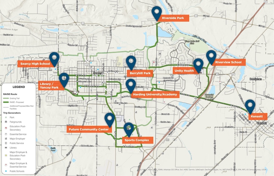
The city of Searcy, Arkansas received a $4,222,900 RAISE planning grant, the largest federal grant the city has ever received, to advance the development of the Little Red Greenway. The funds will support the inclusion of the Little Red Greenway in policies and plans, the collection of public feedback, and the completion of all design and construction plans for the greenway. The planned 15.5-mile greenway will connect to the existing 5.5-mile Searcy Bike Trail and will serve as a connector between the city of Kensett to downtown Searcy. This connection will allow Kensett and Searcy residents to more easily and safely access schools, employment centers, residential neighborhoods and other everyday destinations without the need for a car.
“This grant is a monumental achievement for Searcy,” Mayor Mat Faulkner said. “It not only allows us to improve our transportation infrastructure but also enhances the quality of life for our residents by providing safe and accessible routes throughout the city. We are grateful for the support and are excited to move forward with this transformative project.”
The Little Red Greenway is the result of the master planning document created by City employees and the engineering firm Crafton Tull as well as community partners and stakeholders. Once planning and design is completed through this funding, the city plans to apply for a RAISE capital grant of up to $25 million to make the plans a reality. The city of Searcy’s decision to use their largest federal grant on active transportation, as well as the robust community support that went into developing the concept for the project, underscores the important role active transportation infrastructure plays in rural communities that do not have access to affordable public transit.
Related: City of Searcy Awarded $4.2 Million Grant, Largest in City History
East Deering: Pathways to Bridge the Gap Project
Project At A Glance
- Submitted by: Maine Department of Transportation
- Location: City of Portland, Maine
- Project Type: Capital
- Urban/Rural: Urban
- Amount Awarded: $25,000,000
- Estimated Total Project Cost: $35,146,938
The city of Portland, Maine received a $25,000,000 grant to construct a network of shared-use paths and improve elements of roadway and active transportation infrastructure to bolster safety for non-motorized travelers. Design elements include improved intersection design, separated bicycle lanes, enhanced crosswalks and medians, and lighting improvements. In addition to promoting safe travel for active transportation users, the project will benefit the community through increased affordable transportation options and decreased emissions achieved through mode shift.
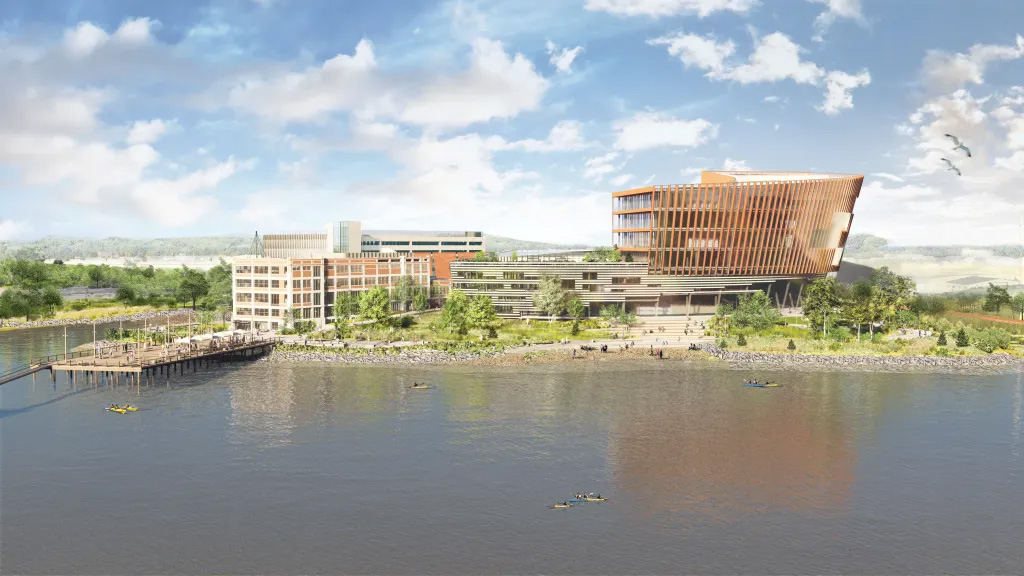
Maine Senator Angus King and Congresswoman Chellie Pingree said the following about the project: “East Deering is an iconic Portland neighborhood that boasts historic residences and beautiful coastline views. As the neighborhood continues to grow, modern infrastructure improvements will be critical to improving community connectivity. This funding from the Bipartisan Infrastructure Law will help revitalize East Deering, making it more accessible and safer for those who call it home.” The project will specifically improve access to Northeastern University’s new Roux Institute campus in the East Deering neighborhood. The Roux Institute is scheduled to open in 2027.
RELATED:
- State gets $25 million for traffic improvements around future Roux Institute in Portland
- Senator Collins Announces $25 Million for MaineDOT Infrastructure Project in East Deering
- East Deering – Pathways To Bridge The Gap Project – Benefit-Cost Analysis
- Local, State, and Federal Leaders Celebrate Biden-Harris Administration’s $1.8 Billion Investment in American Infrastructure Projects, Funded by USDOT RAISE Grants
Campus Complete Streets Improvements
Project At A Glance
- Submitted by: West Virginia Department of Transportation Division of Highways
- Location: City of Beckley, West Virginia
- Project Type: Capital
- Urban/Rural: Rural
- Amount Awarded: $10,475,200
- Estimated Total Project Cost: $13,094,000
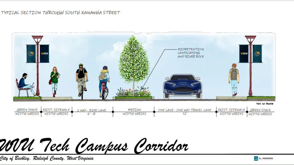
The $10 million dollar grant awarded to the WV DOT Division of Highways will improve connectivity and safety outcomes for the residents of this university district. The Campus Complete Streets Improvement will create one-way traffic flow along South Kanawha Street in front of the West Virginia University Institute Tech campus, create new crosswalks, sidewalks and a bike lane.
Dr. T. Ramon Stuart, WVU Tech president, believes in the idea of the “communiversity” where the community and university function together to benefit one another. He is hopeful for the project and said in one statement that “this funding, and this opportunity afforded by the senators, is an example of how we can work collaboratively to bring resources to southern West Virginia.” With WVU Tech having a $35 million dollar impact on the local economy, Stuart hopes this project will bring additional funding to the city and encourage his idea of “communiversity.”
Related: WVU Tech unveils latest plans for a new traffic pattern in Beckley’s University District
Springfield UNGAP Project
Project At A Glance
- Submitted by: City of Springfield
- Location: City of Springfield, MO
- Project Type: Capital
- Urban/Rural: Urban
- Amount Awarded: $24,822,313
- Estimated Total Project Cost: $24,822,313
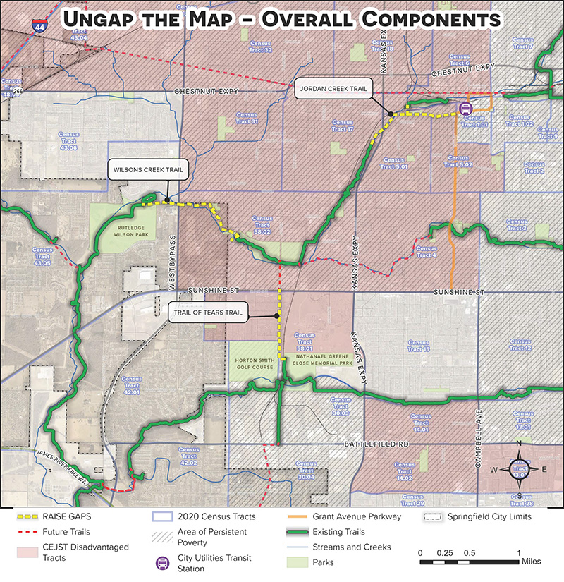
The $24.8 million dollar grant awarded to Springfield, Missouri, will benefit neighborhoods on the westside of the city by constructing 3.14 miles of greenway trails, installing pedestrian bridges and providing dedicated bicycle paths among other infrastructure improvements. While the emphasis of this project is closing gaps and connecting historically marginalized communities to everyday essential destinations, it also prioritizes implementing green street designs that will combine stormwater management with streetscape enhancements.
This grant supports Springfield’s larger comprehensive plan, Forward SGF. More specifically, it advances the city’s UnGap the Map campaign, which promotes expanding and closing gaps in the trail system to ultimately include 200 miles of connected trails. Learn more about this initiative championed by The City and Park Board and Ozark Greenways. In addition to being a city planning priority, the project has also received support from local elected officials. Springfield Mayor, Ken McClure, spoke highly of the process and intended outcomes of this project, saying, “City staff analyzed and prioritized critical gaps in the greenway system based on past community engagement and to target resources in historically impoverished neighborhoods. The project is intended to connect these severed trails and provide a fully connected trail system from westside neighborhoods to natural green space, regional parks, economic opportunities, downtown Springfield, and beyond.”
Successful Fiscal Year 2023 RAISE Trail and Active Transportation Projects
The most recent round of RAISE grants, announced in June 2023, marks the greatest focus yet on trails, walking and biking, funding trail and active transportation projects in nearly every state in the country. Nearly $400 million granted in this round of the USDOT’s competitive, multimodal RAISE program is being invested solely to fund bicycle and pedestrian projects.
Grants that support the needs of bicyclists and pedestrians were distributed in 48 states and Washington, D.C. The scale of investments—representing portions of 80% of the total projects funded—illustrates the significance of creating and connecting walking and biking infrastructure in every region of the country.
Below are two successful trail and active transportation projects from the FY23 RAISE funding that demonstrate how investments in this infrastructure advance goals around safety, equitable access and mode shift. Explore these case studies as you consider whether this funding program is right for your project.
Ala Wai Bridge
Project At A Glance
- Submitted by: City and County of Honolulu
- Location: City of Honolulu, Hawaii
- Project Type: Capital
- Urban/Rural: Urban
- Estimated Total Project Cost: $19,491,061
- Amount Awarded: $25,000,000
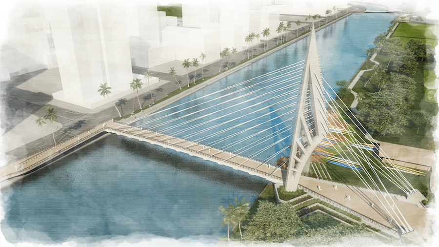
Securing funding for the Ala Wai Bridge is a important progress for the City and County of Honolulu given the project’s significance for community connectivity and emission reduction by supporting mode shift from vehicles to walking and biking. After unsuccessfully applying for funding in the 2021 and 2022 RAISE rounds, Honolulu’s persistence paid off and the city is now receiving $25 million in construction funding for the 300-foot Ala Wai pedestrian and bicycle bridge. The bridge will safely connect McCully-Mō‘ili‘ili to Waikīkī and provide complete streets connections to the University of Hawai’i, accounting for environmental, connectivity, safety and cultural considerations.
Travis Counsell, Executive Director of Hawai’i Bicycling League, notes that the bridge “will provide more direct access and will connect with other complete streets projects to create a safe option for people walking and biking.” Travis adds that the project holds cultural significance because “the design for the bridge will pay tribute to native Hawaiian voyaging canoes, as well as span the whole waterway without any contact with the waterway keeping the Ala Wai canal unobstructed for the local paddling community.”
RELATED: ALA PONO: AN ALA WAI CROSSING
PHX Cultural Corridor Project
Project At A Glance
- Submitted by: City of Phoenix
- Location: City of Phoenix, AZ
- Project Type: Capital
- Urban/Rural: Urban
- Estimated Total Project Cost: $19,491,061
- Amount Awarded: $10,220,242
- Area of Persistent Poverty: Yes
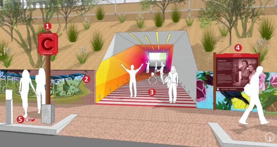
This project enhances connectivity for Phoenix residents by reconnecting disadvantaged communities near Phoenix’s Sky Harbor International Airport to Downtown and South Phoenix. The project will specifically improve active transportation options for non-motorized users by adding approximately 3.3 miles of ADA-compliant sidewalks and improving the roadway with enhanced pedestrian and bicycle facilities, wayfinding signage and pavement markings.
The PHX Cultural Corridor project is part of the larger PHX Land Reuse Strategy, which is designed to redevelop the land west of the Phoenix Sky Harbor Airport and deliver economic benefits to the community and the airport. In a statement about the $10 million grant, District 8 Councilwoman Kesha Hodge Washington said “our residents were clear that they wanted to return vacant lots to productive use so that we can create a vibrant live-work environment and they wanted to celebrate the rich history of our community; this grant will allow us to respond to those requests.” The project, in tandem with the overall land reuse strategy, will benefit the community by stabilizing neighborhoods, increasing access to economic opportunity, and forging a collective identity that honors existing communities.
RELATED: PHOENIX SKY HARBOR AWARDED $10 MILLION RAISE GRANT FOR CULTURAL CORRIDOR
RELATED: PHX LAND REUSE STRATEGY
Successful Fiscal Year 2021 RAISE Trail and Active Transportation Projects
In 2021, the U.S. Secretary of Transportation Pete Buttigieg announced nearly $1 billion in Rebuilding American Infrastructure with Sustainability and Equity (RAISE) grants to “improve infrastructure, strengthen supply chains, make us safer, advance equity, and combat climate change.” This round of grants funded 90 projects in 47 states, Washington, D.C., and Guam. These grants build off the grant program formerly known as BUILD during the Obama Administration and TIGER during the Trump administration. Read more about the history of the grant program here.
Sticking to the priorities of the administration, many of the successful projects focused on increasing connectivity to routine destinations—strong themes throughout active transportation and trail projects. In an unprecedented level of funding in the history of the program, projects that were solely or mainly about trails secured 19% of the overall funding, and projects that were predominantly to make roads safer for vulnerable road users received another 21%.
RELATED: FEDERAL GRANTS RAISE THE BAR FOR ACTIVE TRANSPORTATION INVESTMENTS
We’ve put together a list of trail projects that successfully secured FY21 RAISE funding to highlight what set these projects apart in a highly competitive, multimodal and multijurisdictional grant funding program. Explore these case studies and example grant narratives as you consider whether this funding program is right for your project.
You can find the complete list of projects awarded by the USDOT’s FY21 RAISE planning grants here and capital grants here.
Brickline Greenway: Fairground Park to City Foundry Connector
Project At A Glance
- Submitted by: Great Rivers Greenway
- Location: St. Louis, Missouri
- Project Type: Capital
- Urban/Rural: Urban
- Estimated Total Project Cost: $19,491,061
- Amount Awarded: $15,000,000
- Project RAISE Webpage
- RAISE Narrative
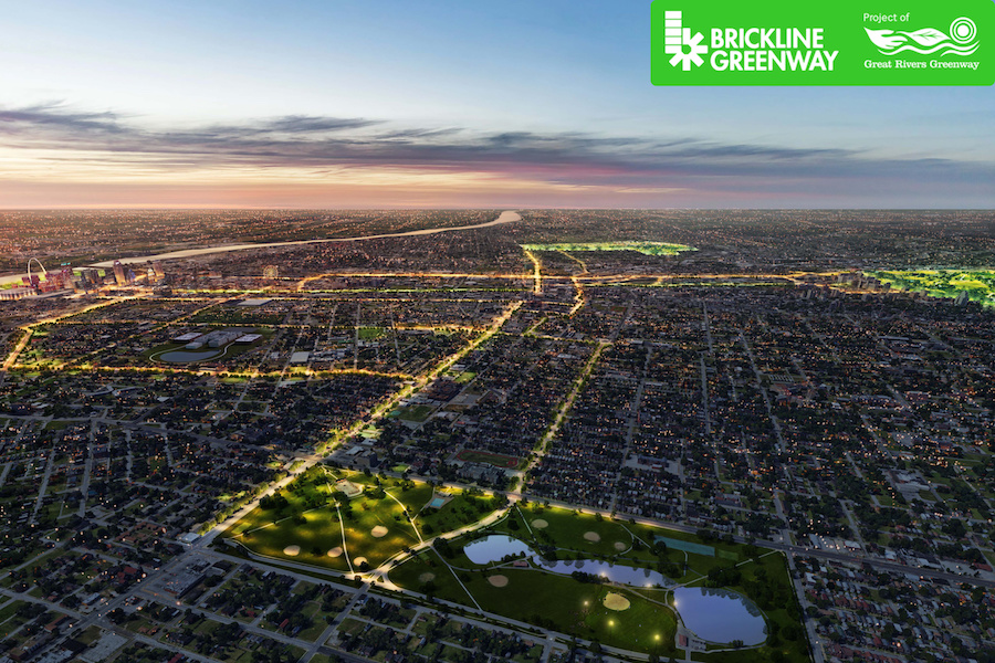
The Brickline Greenway, located in St. Louis, is a network that will include 20-miles of accessible, multiuse pathways. As one of the first segments of the Brickline, The Fairground Park to City Foundry Connector project will comprise roughly two miles of the greenway in North St. Louis.
Relying heavily on public engagement throughout the design and programming of the greenway, Great Rivers Greenway is committed to working with residents to increase connectivity, advance equitable development and reduce racial barriers impacting residents in the project area. Enhanced greenway design and improved bicyclist and pedestrian access to transit will increase transportation choice and connections to school, work, shopping and other services for neighborhoods surrounding the greenway.
RELATED: TRAIL DISTRICT PITCHES $245 MILLION GREENWAYS CONNECTING ST. LOUIS
RELATED: WITH $19 MILLION, BRICKLINE GREENWAY MOVES CLOSER TO CONSTRUCTION
Cleveland Metroparks: RAISE Cleveland Bicycle and Pedestrian Planning
Project At A Glance
- Submitted by: Cleveland Metroparks
- Location: Cleveland, Ohio
- Project Type: Planning
- Urban/Rural: Urban
- Estimated Total Project Cost: $1,500,000
- Amount Awarded: $950,000
- Project RAISE Webpage
- RAISE Narrative
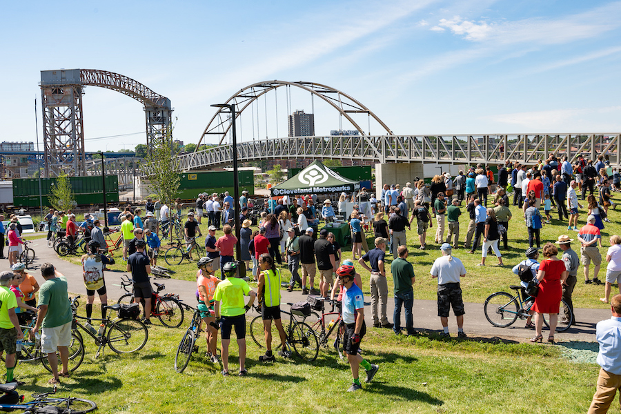
A direct result of the collaboration between Cuyahoga Greenway Partners, the Cleveland Metroparks’ RAISE Cleveland Bicycle and Pedestrian Planning project is part of a regional vision of a network of trails and bike lanes that will serve the transportation, recreation and mobility needs of all residents in Cuyahoga County, Ohio. With nearly 30% of households in the project area not having access to an automobile, a robust active transportation network is an important resource for residents to commute safely and conveniently to work and school and access amenities like public parks.
The RAISE grant advances four projects in the Cuyahoga Greenways Plan—the Slavic Village Downtown Connector Phase 2 North, the Morgana Run/Booth Avenue Extension, Iron Court/Opportunity Corridor Connection, and the Euclid Creek Greenway Phase 2 North. Working together, these segments will fill key gaps and strengthen the overall transportation network on the east side of Cleveland.
RELATED: METROPARKS WINS FEDERAL MONEY TO BUILD EAST SIDE TOWPATH TRAIL EQUIVALENT
Spartanburg County Multimodal Project: Active Transportation to Bridge Racial Equity, Economy and Sustainability
Project At A Glance
- Submitted by: Spartanburg County
- Location: Spartanburg, South Carolina
- Project Type: Capital
- Urban/Rural: Rural
- Estimated Total Project Cost: $66,111,892
- Amount Awarded: $23,845,187
- Project RAISE Webpage
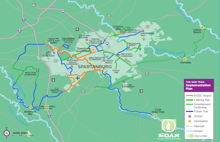
The Daniel Morgan Trail system (“The Dan”) is Spartanburg, South Carolina’s, 50-mile trail system—one of the region’s most transformative infrastructure projects. The Dan provides walking and biking access for residents to jobs, educational opportunities, transit and recreation. The multimodal project will tie The Dan network together by installing nearly 14.6 miles of multiuse pathways and a pedestrian bridge.
The project focuses its routing on increasing the safety and transportation opportunities for residents of Spartanburg County who experience a range of transportation challenges daily, including a gap in access to personal vehicles, high cost of transportation and a lack of quality sidewalks. The rate of traffic fatalities is high in this area, which is worse along rural roads. By providing better opportunities for multimodal transportation, the project will encourage fewer vehicle miles traveled and lower greenhouse gas emissions, while creating new walking and biking routes to access jobs, schools, and other destinations.
Riverside Drive Multimodal Revitalization Corridor
Project At A Glance
- Submitted by: Lehigh Valley Planning Commission
- Location: Allentown, Pennsylvania
- Project Type: Capital
- Urban/Rural: Urban
- Estimated Total Project Cost: $49,455,031
- Amount Awarded: $21,158,854
- Project RAISE Webpage
- RAISE Narrative
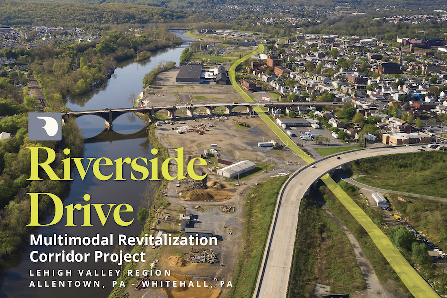
For more than a century, residents of Whitehall Township and the City of Allentown, Pennsylvania, have been cut off from the Lehigh River and adjacent employment centers by industrial development, railroad lines and U.S. Route 22. The Riverside Drive Multimodal Revitalization Corridor project in Allentown is specifically designed to link and unify a diverse, high poverty, low-mobility access population to schools, employment, services, recreation and natural amenities. The project will convert approximately three miles of an abandoned rail line into a two-lane Complete Street with adjacent multi-use path.
By repurposing this dormant rail bed, this project will provide safe, healthy and efficient transportation mode choices to create a more equitable and sustainable system. The commuter corridor will also close the highest priority trail gap in Pennsylvania along the Delaware & Lehigh National Heritage Corridor while simultaneously providing a missing north-south connection between the region’s bus rapid transit network.
RELATED: AFTER YEARS OF FIGHTING FOR CRITICAL LINK IN D&L TRAIL, $21M GRANT COMING TO LEHIGH VALLEY
Yolo County Bike and Pedestrian Trail Network Planning Project
- Submitted by: Yolo County Transportation District
- Location: Yolo County, California
- Project Type: Planning
- Urban/Rural: Rural
- Estimated Total Project Cost: $1,700,000
- Amount Awarded: $1,200,000
This planning grant for Yolo County, California, will help fund the development of an active transportation network that is based on community outreach and the prioritization of historically underserved communities in the region.
Hominy Creek Greenway and Trail Network Plan
- Submitted by: City of Wilson
- Location: Wilson, North Carolina
- Project Type: Planning
- Urban/Rural: Rural
- Estimated Total Project Cost: $1,200,000
- Amount Awarded: $950,000
The Hominy Creek Greenway and Trail Network Plan RAISE grant will help plan a trail along 3.8 miles of Hominy Creek in Wilson to provide a safe, nonmotorized travel alternative and increase environmental sustainability by incorporating stormwater mitigation.
NATIVE III – Trail to Mertarvik
- Submitted by: Nunakauyarmiut Tribe
- Location: Nelson Island, Alaska
- Project Type: Capital
- Urban/Rural: Rural
- Estimated Total Project Cost: $13,360,000
- Amount Awarded: $12,075,000
After coastal erosion pushed the Village of Newtok to relocate, this 30-mile Geocell Native III – Trail to Mertarvik project in Nelson Island, Alaska, will connect the newly relocated village to existing trail infrastructure and to medical services and the Island’s regional hub at Toksook Bay.
Delta Heritage Trail: Connecting Rural Communities
- Submitted by: Arkansas Department of Parks, Heritage, and Tourism
- Location: Snow Lake, Arkansas
- Project Type: Rural
- Urban/Rural: Capital
- Estimated Total Project Cost: $41,800,424
- Amount Awarded: $20,482,208
The Delta Heritage Trail: Connecting Rural Communities project will conclude the final three phases of the 84.5-mile multi-use trail corridor, expanding health and mobility options for residents and boosting outdoor recreation and tourism.
From Tracks to Trails: Reconnecting Atlanta Communities
- Submitted by: City of Atlanta
- Location: Atlanta, Georgia
- Project Type: Capital
- Urban/Rural: Urban
- Estimated Total Project Cost: $38,865,641
- Amount Awarded: $16,460,000
By increasing connectivity for communities previously bisected by railroads, Atlanta’s From Tracks to Trails: Reconnecting Atlanta Communities project aims to promote economic competitiveness and proactively address gentrification and displacement.
Completing the Vision – The Marquette Greenway
- Submitted by: Northwestern Indiana Regional Planning Commission
- Location: City of Chicago, City of Gary, Town of Ogden Dunes, City of Portage, Town of Burns Harbor, Porter County, City of Michigan City, New Buffalo Township, City of New Buffalo; Indiana, Illinois, Michigan
- Project Type: Capital
- Urban/Rural: Urban
- Estimated Total Project Cost: $30,767,516
- Amount Awarded: $17,799,282
This project will complete the remaining 20 miles of the Marquette Greenway, a planned 60-mile active transportation route spanning three states, five counties and nine municipalities, expanding access to existing trails, transit, jobs and retail and recreational opportunities.
Durham Belt Line
- Submitted by: City of Durham
- Location: Durham, North Carolina
- Project Type: Capital
- Urban/Rural: Urban
- Estimated Total Project Cost: $16,341,800
- Amount Awarded: $9,000,000
The Durham Beltline will repurpose an old railroad corridor to create a 1.75-mile shared-use path that connects downtown to central and northeastern Durham, promoting safety and expanding quality of life for residents.
High Point on the RISE
- Submitted by: North Carolina Department of Transportation
- Location: City of High Point, North Carolina
- Project Type: Rural
- Urban/Rural: Capital
- Estimated Total Project Cost: $27,889,089
- Amount Awarded: $19,801,253
A combination of greenway construction and Complete Streets improvements, the High Point on the RISE project aims to increase safety for vulnerable road users, improve air and water quality, and connect historically marginalized neighborhoods to commercial districts in southwest and downtown High Point, North Carolina.
Council Creek Regional Trail Project
- Submitted by: Washington County
- Location: Washington County, Oregon
- Project Type: Capital
- Urban/Rural: Urban
- Estimated Total Project Cost: $16,500,000
- Amount Awarded: $12,200,000
The Council Creek Regional Trail Project will construct 6 miles of multiuse trails along an unused railroad right-of-way, providing safe, accessible and environmentally friendly transportation options to residents in predominantly low-income communities in Washington County, Oregon.
The LOOP: Uniting Neighborhoods with Urban Trails
- Submitted by: Texas Department of Transportation
- Location: Dallas, Texas
- Project Type: Capital
- Urban/Rural: Urban
- Estimated Total Project Cost: $36,800,000
- Amount Awarded: $12,000,000
This project will advance 11 miles of The Loop, a 50-mile urban trail in Dallas, Texas, improving safety and increasing transportation mode choice for area residents.
BUILD Stories
View More Blogs
Congress Takes First Step On New Transportation Law
BUILD America 250 Act Poses Challenges for America’s Active Transportation Future