Ohio’s Simon Kenton Trail
Trail of the Month: October 2017
“Springfield is beginning to define itself with great outdoor opportunities.”
Western Ohio’s Simon Kenton Trail, named for an 18th-century frontiersman (and friend of Daniel Boone), offers the perfect opportunity for today’s travelers to do their own exploring of the state’s scenic woodlands and rural landscapes on a 35-mile adventure stretching from Springfield to Bellefontaine. For an even more epic experience, the trail is seamlessly integrated into the expansive Miami Valley trails network, which offers 340 miles of paved trails coalescing in and around the Dayton metro area.
“Springfield is a Midwest town—an urban area in the middle of a rural county,” says Louis Agresta, a bicycle/pedestrian planner with the Clark County-Springfield Transportation Coordinating Committee. “It’s very dynamic to have downtown Springfield only 10 miles away from farming and agriculture. It’s an old manufacturing place trying to find its way with a wonderful parks and trail system. Springfield is really beginning to define itself with great outdoor opportunities.”
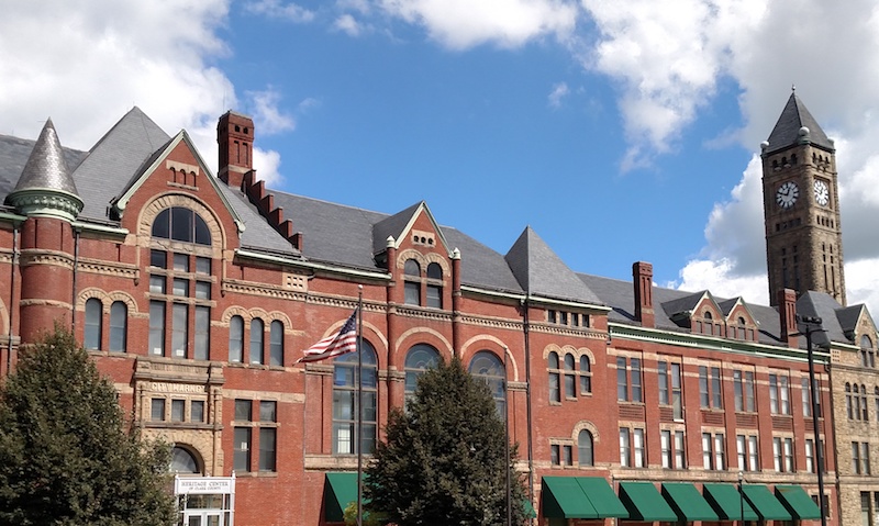
To dig into the region’s rich history and culture, there’s no better place to begin your journey than the Heritage Center at the trail’s southern end in downtown Springfield. Spanning a city block, the beautiful brick and stone building was constructed in 1890 and once housed a city hall and marketplace. Inside, you’ll find a charming café and exhibits from the Clark County Historical Society. It’s also worth noting that you can pick up the Little Miami Scenic Trail from here and go all the way to Cincinnati’s doorstep, a distance of 78 miles, all on paved trail.
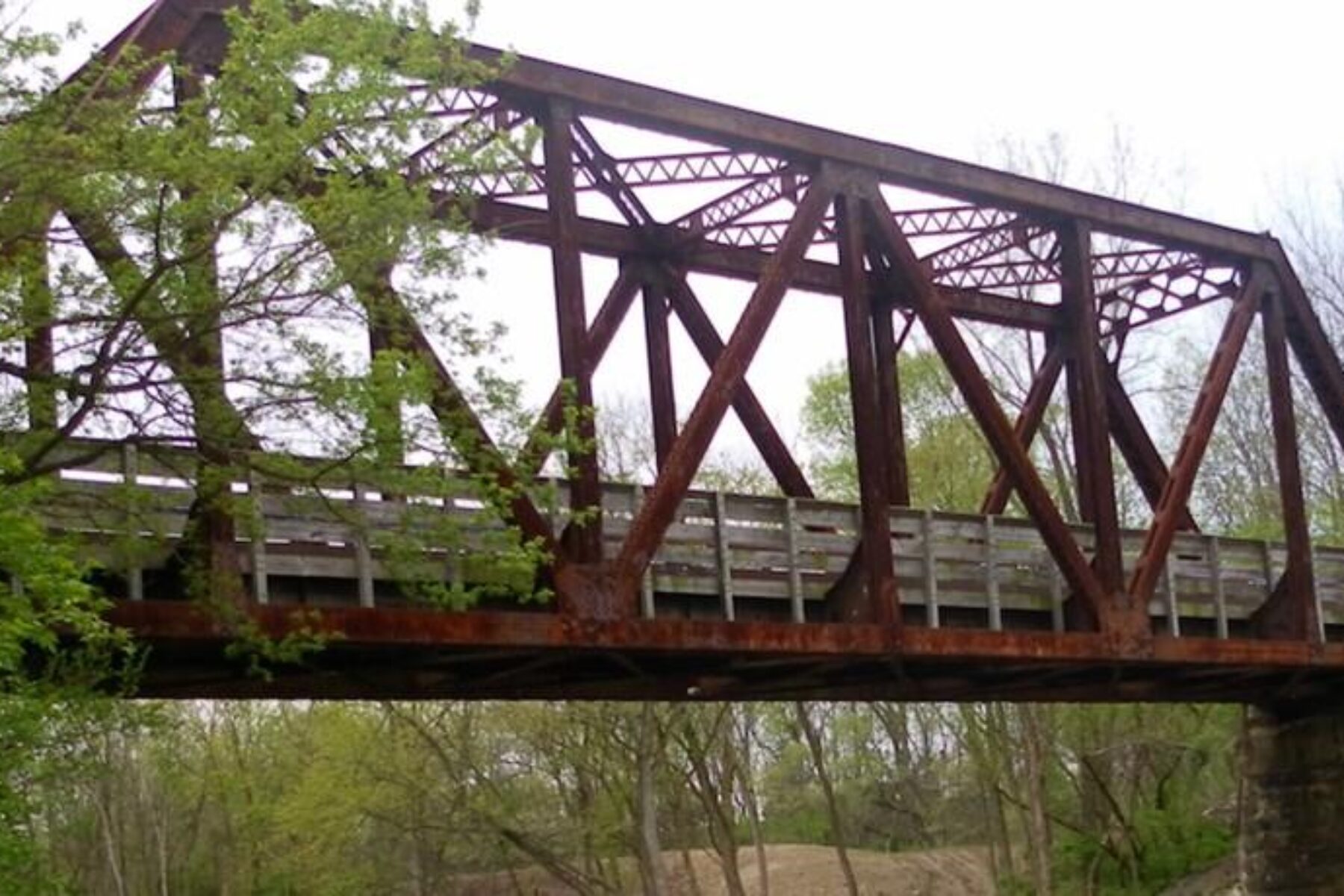
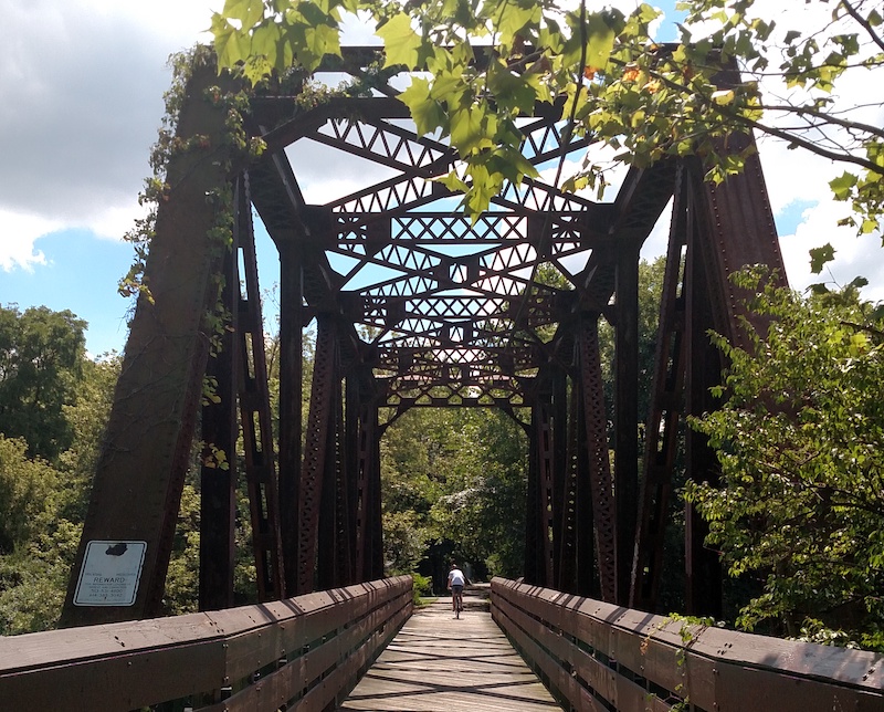
From the Heritage Center, it’s only a half-mile before you reach an opportunity to diverge a few blocks off the trail to tour another of the city’s historical treasures, the unique Westcott House, designed by Frank Lloyd Wright in 1906 and the only Prairie Style home in the state. A mile farther north, the trail’s railroad history is on display with a refurbished 1916 bridge over Buck Creek. Another trail meets the Simon Kenton here and follows the creek eastward to Buck Creek State Park, which offers camping and lots of recreational activities in and around the massive lake at its center. Agresta notes that this is a key juncture as the Simon Kenton is an important north-south thoroughfare in the region, while the Buck Creek goes east-west.

“There’s wildlife all along Buck Creek,” notes Leann Castillo, director of the National Trail Parks & Recreation District, which maintains the Simon Kenton Trail within Clark County and is headquartered at this trail intersection. “You’ll see lots of deer, foxes, snakes, turtles, owls and great blue herons flying up and down the trail. There are even bald eagles nesting here.”
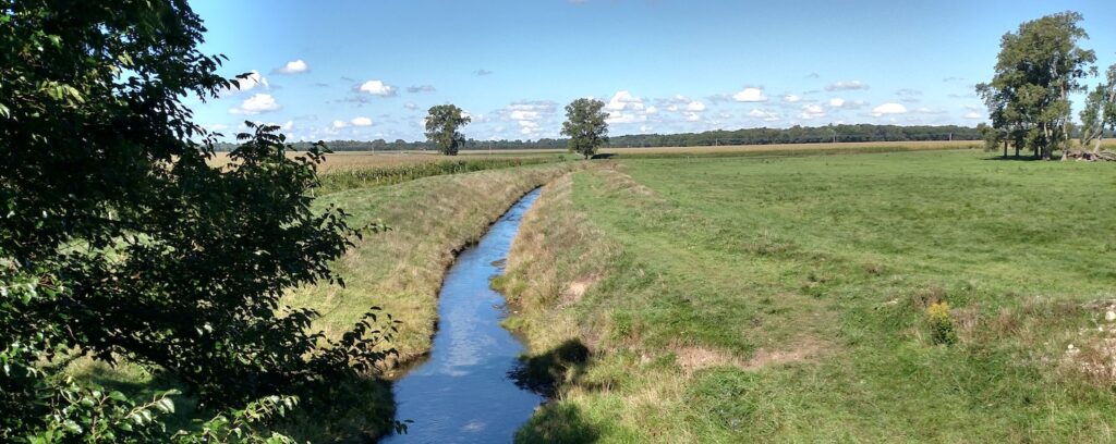
As the trail heads north out of Clark County and into Champaign County, it becomes more open, passing through farm fields and meadows of wildflowers. Agresta adds that as you approach Urbana, the old rail corridor is elevated, so it’s like a “sky ride through town; you’re way above the surface roads.” In Urbana, travelers will have another connection to the trail’s railroad past, coming upon a restored 1850s Pennsylvania Railroad depot.
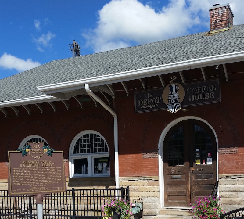
“Right in Urbana, there’s an old train depot that has a coffee shop and café inside it, plus a fix-it station outside,” says Eric Oberg, RTC’s trail development director for the Midwest Regional Office. “It makes for a killer trailhead and is a real focal point for the trail. It’s such an awesome reuse of a cool old building in the center of town.”
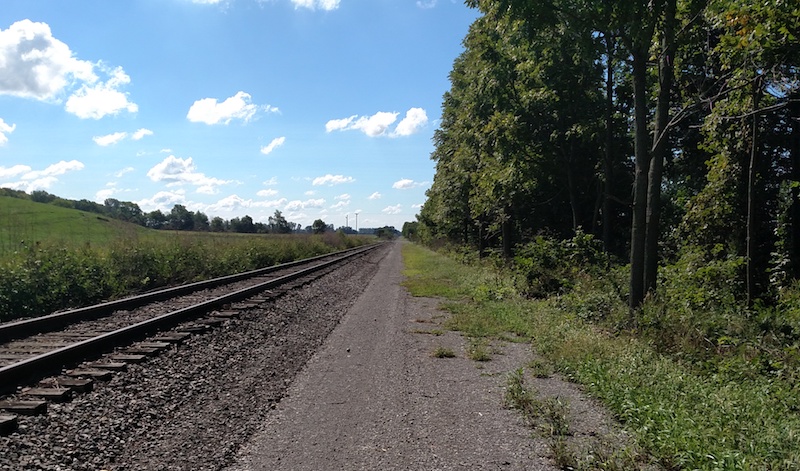
From Urbana northward to its end in Bellefontaine, the trail parallels still-active though infrequently used tracks in a configuration known as rail-with-trail. Along the way, the trail skirts West Liberty, which, though small in population, is not short on charm. The village just celebrated its bicentennial this summer and offers several unique attractions within a short distance of the pathway, including the Ohio Caverns, marketed as “America’s Most Colorful Caverns,” and Marie’s Candies, a chocolate factory housed in a historical train depot.
But this part of the trail almost didn’t open. In a fiscally tight, rural county, it took the fundraising might of the Simon Kenton Pathfinders—a volunteer-run organization headed by founding member Nancy Lokai-Baldwin, whom Oberg calls, “a force of nature”—to make the trail a reality. All the funds for the project were provided through grants and private donations raised by these dedicated citizens.
“The Pathfinders didn’t stop at the initial trail connecting Springfield to Urbana,” says Oberg. “The first stretch of the trail was opened 15 years before. Building a trail is so much work, and they could have just stopped there with the first phase and said, ‘job well done.’ It still would have been fabulous if that’s all they ever did, but they went all in to do more, and the year before last, they opened the Urbana to Bellefontaine stretch.”
Unlike the southern half of the trail, which is paved, these final 16 miles have a crushed-stone surface. The decision about the surface was not an easy one to make.
“The Springfield to Urbana section is paved, but with this new extension they couldn’t afford to pave it,” says Oberg. “They had to make a choice whether or not to construct the trail and open it with a natural surface or wait until they had enough money to pave it. They heard some negative feedback because people out here are used to pavement, but they did the best they could with what they had.”
The Pathfinders are listening to the trail community and have raised enough money to surface a test section spanning a couple of miles with chip seal, which, while not as firm as pavement, is closer to that experience than the current stone surface. “They’re an organization that does a lot with a little,” says Agresta of the Pathfinders group, which celebrated their 20th anniversary this year.
The trail has been a catalyst for other groups as well, like the Trail Riders and the Trail Walkers, which meet weekly for outings on the trail, and the Trail Ambassadors, which patrol the trail in distinctive shirts to answer visitor questions, provide directions and distribute trail literature. All three groups are supported by the National Trail Parks and Recreation District. Connecting several schools, and kid-friendly attractions like Springfield’s Splash Zone Aquatic Center and a soccer complex, the Simon Kenton Trail is truly a well loved and well used community asset.
Related Links
Simon Kenton Pathfinders
National Trail Parks & Recreation District
Clark County-Springfield Transportation Coordinating Committee
Miami Valley Trails
Trail Facts
Name: Simon Kenton Trail
Used railroad corridor: The rail-trail follows the former Pennsylvania Railroad route. The northern section of the trail is also a rail-with-trail as it parallels a still-active rail line for 16 miles from Urbana to Bellefontaine.
Trail website: Simon Kenton Pathfinders
Length: 35.5 miles
County: Champaign, Clark, Logan
Start point/end point: W. Washington Street and S. Center Street (Springfield) to Carter Avenue, 0.1 mile west of Detroit Street (Bellefontaine)
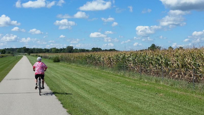
Surface type: The southern end of the trail, from Springfield to Urbana, is surfaced with asphalt; the northern end of the trail, from Urbana to Bellefontaine, is crushed stone.
Grade: As Bellefontaine includes the highest point in Ohio, if you start from the northern end of the trail, you’ll have a gradual downhill ride to the southern end in Springfield.
Uses: Walking, biking, inline skating and cross-country skiing; wheelchair accessible
Difficulty: The paved, southern end of the trail, from Springfield to Urbana, is easy. For the unpaved northern end of the trail, between Urbana and Bellefontaine, trail users may prefer to use a hybrid or mountain bike.
Getting there: The closest major airport to Springfield is Dayton International Airport (3600 Terminal Drive, Dayton), located about 26 miles from the trail’s southern end.
Access and parking: Here we’ve listed parking directions for the northern and southern ends of the trail. For additional options in between, please use TrailLink.com or trail maps available from the websites of the local organizations listed above.
To reach the northern endpoint in Bellefontaine from I-75, take Exit 110. Head east on US 33, and go 11.6 miles. Turn right to remain on US 33, and go 12.9 miles to the exit for County Road 37. Turn right onto CR 37, and in 0.1 mile, turn left onto CR 130. In 4.8 miles, turn right onto Troy Road, and go 1 mile. Turn left onto Plumvalley Street, and in 0.3 mile, turn right onto Carter Avenue. The trailhead is located on the right, 0.2 mile ahead.
The southern endpoint is located at the Heritage Center in downtown Springfield, but parking there is limited. Instead, park at the trailhead on Villa Road north of downtown. To reach the trailhead, take I-70 to Exit 52B. Head north on US 68, and go 7 miles to the exit for OH 334. Turn right onto OH 334, stay in the right lane, and in 0.2 mile take the first ramp onto OH 72, heading south. After 1 mile, turn left onto Villa Road. Parking is located on the right after 0.3 mile.
To navigate the area with an interactive GIS map, and to see more photos, user reviews and ratings, plus loads of other trip-planning information, visit TrailLink.com, RTC’s free trail-finder website.
Rentals: Your best bet for bike rentals is Xenia, Ohio, which lies 20 miles south of Springfield and serves as a major hub of the Miami Valley trail system. You can even cover that distance by bike instead of by car as the Little Miami Scenic Trail runs between Xenia and Springfield, where it seamlessly connects to the Simon Kenton Trail. Xenia’s K&G Bike Center (594 North Detroit St.; 937.372.2555) is located across the street from the Little Miami and offers all types of bikes, including tandems and options for kids, on an hourly, daily or weekly basis.

Donate
Everyone deserves access to safe ways to walk, bike, and be active outdoors.