Minnesota’s Mesabi Trail: October 2025 Trail of the Month

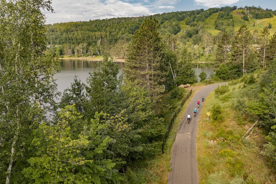
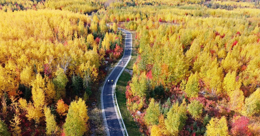
Traversing the scenic Iron Range of northern Minnesota, the Mesabi Trail spans 165 miles “from the Mississippi River to the Boundary Waters” between Grand Rapids and Ely. As a major recreational draw for the region, the trail has boosted the economies of the 28 communities—many with deep ties to the mining industry—that have been connected by the route over the more than three decades of its development.
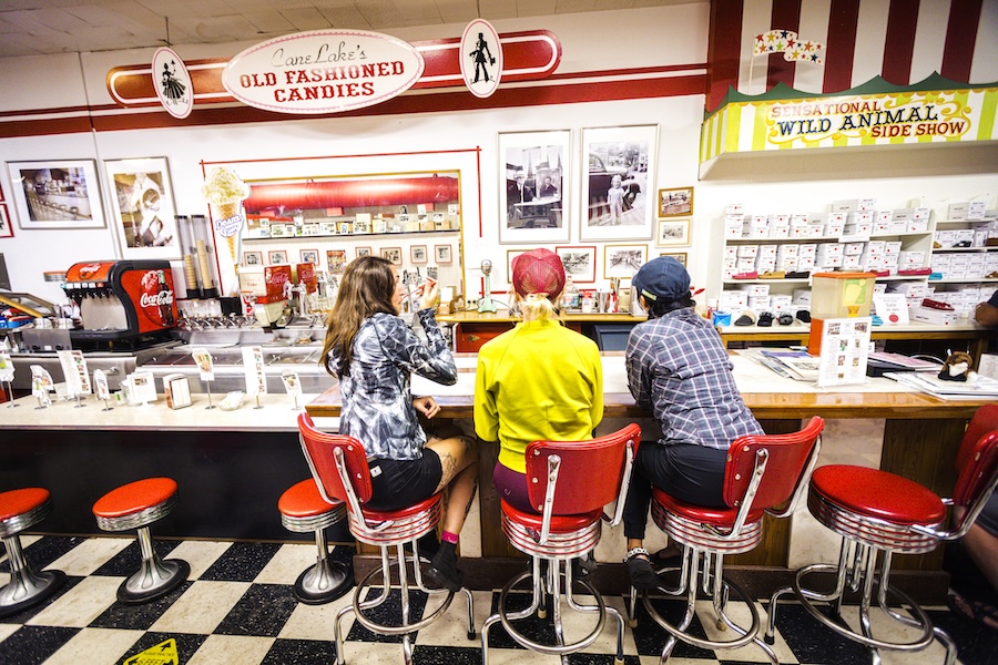
Boxes of chocolates, turtles and hot air candies crowd the shelves at Canelake’s Candies in the northern Minnesota city of Virginia, about 60 miles outside of Duluth. The shop has been a beloved staple since 1905 and is reportedly the oldest candy store in Minnesota. Third-generation owner Pamela Canelake Matson beams with pride as she comes out from the kitchen, pointing to black-and-white photos on the wall of her grandfather, uncle and dad, all of whom previously owned the shop.
“There’s a lot of history in here,” Matson said, giving us a tour of the expanded kitchen where workers use the same type of copper kettles and bowls to heat the candy as they did when the shop first opened. Laminated newspaper clippings from over the years lie in a pile atop a retro 1950s-style diner counter.

Tourism dollars from Mesabi Trail visitors have allowed Canelake’s to expand into an adjacent gift shop where they sell locally made products, moccasins and more candy. Vintage candy machinery, like ribbon candy makers, and Virginia memorabilia, including shop photos from the 1950s, transform the place into a time capsule. The store plans to expand even further to a bar next door, where they will have a grab-and-go area with sandwiches, pastries and coffee for bicyclists and hikers coming from the trail.
“We have seen more bikers recently,” Matson said. “Tourism is on the rise for downtown Virginia, and we’re really happy to see that they’ve got more businesses opening.”
Connecting the Iron Range

Virginia is just one of 28 communities—all with populations less than 20,000—connected by the Mesabi Trail, which stretches 165 miles across the state’s scenic Iron Range, an area with a mining history deeply embedded in its terrain. From Grand Rapids to Ely, the paved pathway unfurls between the Mississippi River and the glacial lakes of the Boundary Waters (so named for their proximity to the Canadian border).
“The scenery is stunning, and when you look across the landscape and you realize that the lake before you was actually a mined out pit formed by man, it’s pretty inspiring,” said Sarah Ciochetto, deputy director of the St. Louis and Lake County Regional Railroad Authority, which manages the trail. “But if you come up here, it’s not just about riding the trail. It’s about experiencing the communities along the way. A lot of the businesses are little mom-and-pop stores still.”
One of the most popular items at Canelake’s is chocolate-covered, popped wild rice. The rice is supplied by the Bois Forte Band of Chippewa Indians at the Nett Lake Reservation.
“The Nett Lake Reservation supplied us with the wild rice for selling, and then one day a guy named Chris Holm came in and said, ‘I’d like to show you how to pop the rice,’ then we dipped it in chocolate,” Matson explained. “I asked, ‘Did you want us to help and you can use our kitchen and make some for your organization?’ He said ‘No, but the recipe is yours, you can take it and use it.’ So we’ve been making it ever since.”

The crispy treat has a satisfying crunch between thick layers of chocolate. It’s just another example of how the communities work to support each other. There’s even interest in expanding the trail to connect to facilities on the Bois Forte Reservation, like the Fortune Bay Casino and Bois Forte Heritage Center & Cultural Museum, according to Beth Pierce, executive director for the Iron Range Tourism Bureau.
This article was originally published in the Winter 2025 issue of Rails to Trails magazine and has been reposted here in an extended format. Subscribe to read more articles about remarkable trails while also supporting our work.
History Runs Deep

Originally, this area was inhabited by the Ojibwe people, but in the early 1890s, it was colonized by European settlers who thought it was rich with gold and timber. But instead of gold, iron ore veins were discovered, and the “Iron Range” name took hold.
“The way it was discovered was because peoples’ compasses would not work. It was that powerfully magnetic, and it was close to the surface in a lot of places,” Pierce said. “So there were all these kind of small holes that were dug in the ground that became mines. There was a combination of underground and above ground mining, and it continues to this day.”

Vestiges of this heritage can be seen trailside in places like Lake Ore-Be-Gone, created by the flooding of three former open-pit mines, and Soudan Underground Mine State Park, where tours are taken more than 2,300 feet down a mine shaft dating back to 1882. The trail also crosses the Thomas Rukavina Memorial Bridge, Minnesota’s tallest bridge at 204 feet, which overlooks another water-filled iron mine.
According to Pierce, there are still six active mines in the area, though they now mine a lower grade of ore called taconite, which is used in blast furnaces to make steel.
The Mesabi Trail itself was once a rough dirt road used by miners to transport the ore in the late 1800s before the route was eventually transformed into the St. Louis and Lake Counties railroad system. Although partially a rail-trail, the modern-day route isn’t completely flat or straight. It winds and curves with hills of up to 8% grade, reaching approximately 3,000 feet of elevation change. This makes for a leisurely ride in some areas, and uphill climbs and fast downhill sections in others.
“The miners had to get from Mesabi Station, which was the only railroad point bringing people up north, and head west to Grand Rapids—it was a long, arduous journey for them,” said Ciochetto. “And now we’ve got this Mesabi Trail, which is connecting the towns just like that original one did. Part of the trail goes through mine pits, and you can see working mines from there. Mining really made this area what it is, and we take a lot of pride in that up here.”
In 1986, the St. Louis and Lake Counties Regional Railroad Authority was formed to acquire the former railroad corridors from the area’s mining companies. After receiving a Recreational Trails Program grant in 1993, they were able to get to work constructing the Mesabi Trail. At the time, a critical supporter of funding for trails both in the state and nationally was longtime U.S. Congressman Jim Oberstar, who was an avid cyclist that grew up in Chisholm, a small city along the Mesabi Trail dubbed “The Heart of the Iron Range.”
Natural Passion

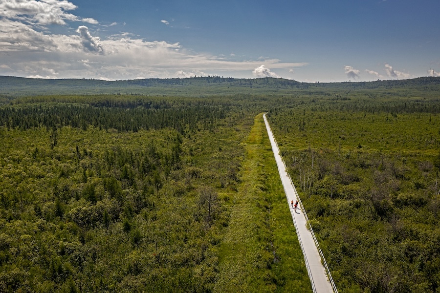
In addition to the trail’s tangible history, the Mesabi Trail’s access to the region’s unparalleled natural scenery is another huge draw. The route traverses lush wilderness, lowlands and boggy wetlands, travels past numerous lakes (including Lake Vermilion, one of the state’s largest), and ends in Ely at the doorstep of the International Wolf Center, Superior National Forest and Boundary Waters Canoe Area. Moose, elk and bear might even be glimpsed in its boreal forests.
In 2016, a whopping 86% of visitors surveyed indicated they came to the region specifically for the trail, according to a University of Minnesota report, and today, the Mesabi Trail averages nearly 200,000 visits a year, mostly by people on bikes. Mesabi Station, centrally located along the route in Eveleth, not only serves as a trailhead, but doubles as a tourist information center.
But tourists aren’t the only ones who flock to the Mesabi Trail. Even on chilly days, locals can be seen walking their dogs or taking a quick stroll.

“All of these towns are benefitting from the tourism dollars, but they are also enjoying it,” said Paula Kangas, executive director for Club Mesabi. “The communities have their own walking groups and biking groups. We have geocaching that happens on the trail. When we opened up the Soudan-to-Ely section, that was huge. Every time I go there, I’d be amazed if I went 10 minutes without seeing a biker on the path.”
Ciochetto is happy to see this shift in perspective from when the trail’s first section— between the communities of Mountain Iron and Virginia—opened in 1996. She worked with many residents who initially had concerns about the amount of people coming through and disrupting their peace, but they’ve turned into supporters after seeing how it offers the community a chance to get out in nature.
“As people have seen it and experienced it, they realize that although we have a lot of trail users, it’s not like they’re all there on the same day,” Ciochetto said. “You can go out, be on the trail, and you might not see anybody, or you might see a dozen people, and everybody just seems happy and content being out there. And we strive to maintain that with whatever we do. We really try to work hard with the people around us to ensure that it’s engaging and something that will be good for as many people as we can make it good for.”
A Growing Legacy

To keep the three-decades-old trail in good condition, a “wheel pass” is required of any trail user who is 18 or over on a bike, rollerblades or skateboard (walkers and people using mobility devices are exempted). The trail passes are sold by Club Mesabi, a nonprofit membership organization that fundraises and promotes the trail, including hosting seasonal events along it.
“We just had a pet walk, and we have a Read and Ride in Calumet in partnership with the library where the youth ride part of the trail, and when they come back, we read them a story. We just like to do something different to get people on the trail and get them outdoors,” said Kangas. “My goal is to do as many community rides as we can and get every city involved. We also build great relationships through all the businesses, our wheel pass vendors and our residents that try to keep the trail nice and clean.”
Currently, only a small, 6.5-mile gap of the 165-mile route remains unfinished. Ciochetto told us they are in the design phase of this stretch, located between the towns of Embarrass and Tower near the trail’s northern end, and it’s slated for completion in the next two years. (Updates on the trail’s construction can be found on the Mesabi Trail website.)
“As the trail has grown, so has interest and usership,” Ciochetto enthused. “Being so close to a final product of the master plan, there is definitely more interest from folks wanting to ride the entire thing.”
Related Links
Trail Facts
Name: Mesabi Trail
Used railroad corridor: St. Louis and Lake County Railroad System
Trail website: Mesabi Trail
Length: 165 miles (Only a 6.5-mile gap remains uncompleted.)
Counties: Itasca, St. Louis
Start point/end point: Itasca County Fairgrounds (1336 Fairgrounds Road, Grand Rapids) to E. Sheridan St./MN-169, across from the International Wolf Center (Ely)
Surface type: The trail is fully paved, except for a gravel stretch of less than a mile through the Darwin S. Myers Wildlife Management Area near Embarrass.
Grade: Although partially a rail-trail, the route isn’t completely flat or straight. It winds and curves with hills of up to 8% grade reaching approximately 3,000 feet of elevation change.
Uses: Walking, running, biking, inline skating, fishing, cross-country skiing and snowmobiling; wheelchair accessible (Note: The trail is not groomed in the winter months.)
Difficulty: The experience is considered easy to moderate for most people.
Getting there: Range Regional Airport, which is serviced by Delta Air Lines, is located less than 10 miles from the Mesabi Trail in Hibbing, roughly midway along the route. The larger Duluth International Airport, is located about 60 miles from the trail.
Access and parking: Over two dozen parking locations are available along the Mesabi Trail. Here are a few of those locations (from south to north):
- Grand Rapids: Itasca County Fairgrounds (1336 Fairgrounds Road)
- Hibbing: Greyhound Bus Museum (1201 Greyhound Blvd.)
- Eveleth: Mesabi Station (111 Station 44 Road)
- Tower: Tower-Soudan Depot Museum (404 Pine St.)
- Ely: Kawishiwi Ranger Station, Superior National Forest (1393 MN-169)
To navigate the area with an interactive GIS map, and to see more photos, user reviews and ratings, plus loads of other trip-planning information, visit TrailLink™, RTC’s free trail-finder website.
Rentals: Ardent Bikes (301 NW First Ave., Grand Rapids; 218.999.5470), located just over a mile from the southern end of the trail, offers bike rentals. Located roughly midway along the trail route is Bikes on Howard (407 East Howard St., Hibbing; 218.262.0899). And farther north, Giants Ridge (6329 Wynne Creek Dr, Aurora; 218.262.0899) is another option for bike rentals.

Donate
Everyone deserves access to safe ways to walk, bike, and be active outdoors.


