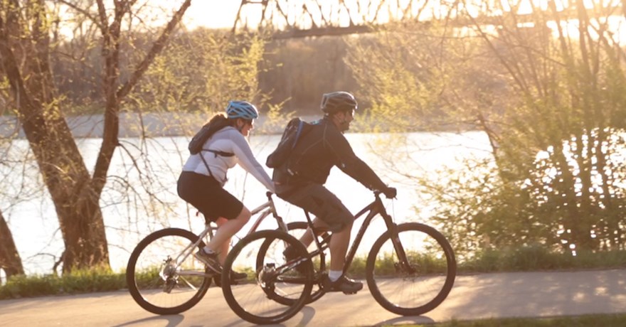
Top 10 Trails in North Dakota
From the fertile flatlands of the Red River Valley in the east to the rugged badlands near Theodore Roosevelt National Park in the west, trails in North Dakota beautifully play up the history of the state that bills itself as the place “where legends are born.”
With a population of less than 1 million, North Dakota has long been known mostly for its agriculture and its oil fields. But alongside the grain fields and oil derricks is a growing system of recreational trails that follow old railroad lines and lush riverbanks.
The state’s legendary past is never far away—whether you’re walking in the footsteps of early badlands rancher and former President Teddy Roosevelt, following the bend of the Missouri River where explorers Lewis and Clark met up with their Shoshone guides, including Sacagawea, or walking across an abandoned railroad lift bridge that crosses the Yellowstone River along the Montana border.
For a splendid mix of scenery and history, here are top 10 trails in North Dakota.
Greenway of Greater Grand Forks
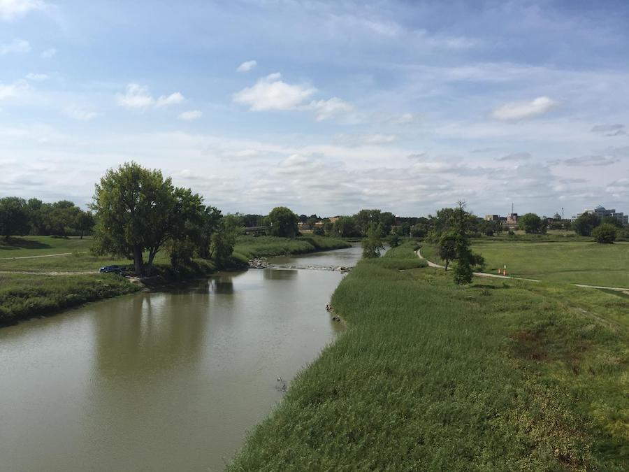
County: Grand Forks
In the spring of 1997, massive flooding of the Red River of the North devastated the community of Grand Forks, a university city in the northeast corner of the state. The region had long been plagued with flooding from this river that marks the North Dakota/Minnesota border, and in an effort to mitigate the seasonal flooding, the Greenway of Greater Grand Forks was born.
Today, the 2,200-acre greenway lines the Red River and Red Lake River as they flow through Grand Forks and East Grand Forks, Minnesota. The lush riverside area provides all-season recreational opportunities for hiking, walking, running, rollerblading, biking, birding, canoeing, kayaking, fishing, golfing and cross-country skiing. The Greenway of Greater Grand Forks consists of 21.1 miles of paved paths. A 10-mile loop through both Grand Forks and East Grand Forks allows bikers and hikers to link up with other trails through each city, as well as with the 100-mile Rural Bicycle Loop in Grand Forks.
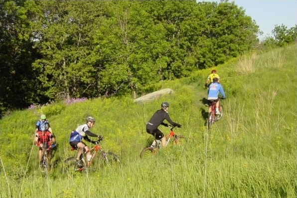
Maah Daah Hey Trail
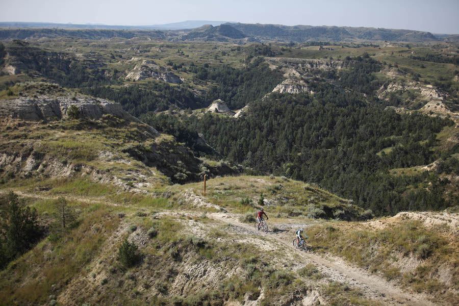
Counties: Slope, Billings, McKenzie
For a walk (or bike ride) on the wilder side of the state, North Dakota’s epic Maah Daah Hey Trail offers the perfect spot. At 144 miles long, the Maah Daah Hey cuts a single-track swath through the rugged buttes, plateaus and rolling prairies of western North Dakota’s badlands.
Perhaps the most iconic trail in the state, the Maah Daah Hey starts about 30 miles south of the Theodore Roosevelt National Park gateway town of Medora and heads north toward the park’s spectacular North Unit. Although best known as a long-distance mountain-biking trail, the Maah Daah Hey can also be done in smaller hiking adventures from its numerous convenient access points available at campgrounds and trailheads.
Legends of Theodore Roosevelt run deep in the North Dakota Badlands. The former president famously ranched in the area in the 1880s—a stint that historians say set the groundwork for later preservation efforts that earned Roosevelt the designation as the nation’s conservation president.
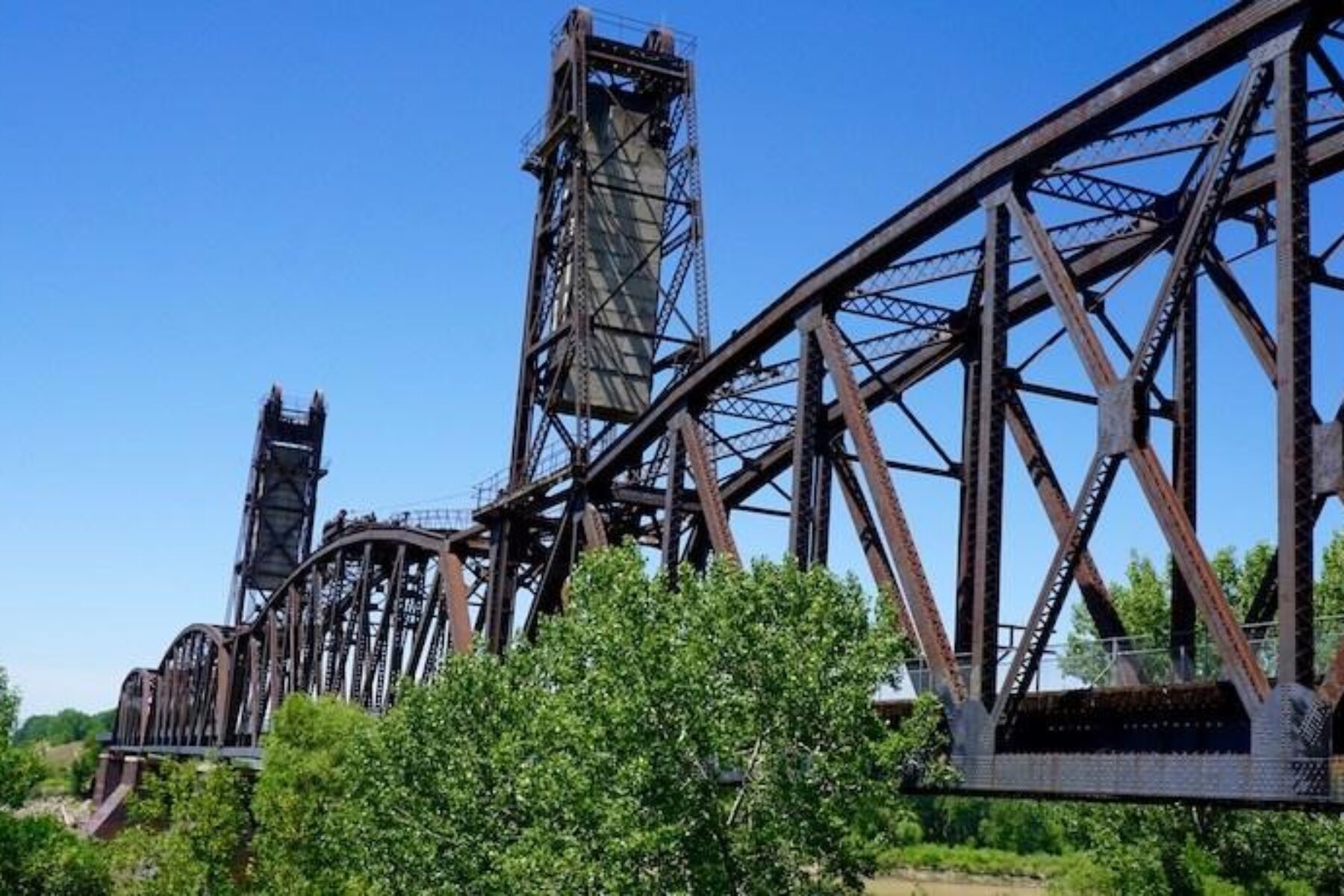
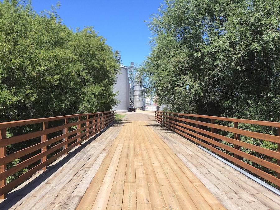
Fairview Bridge & Cartwright Tunnel Trail
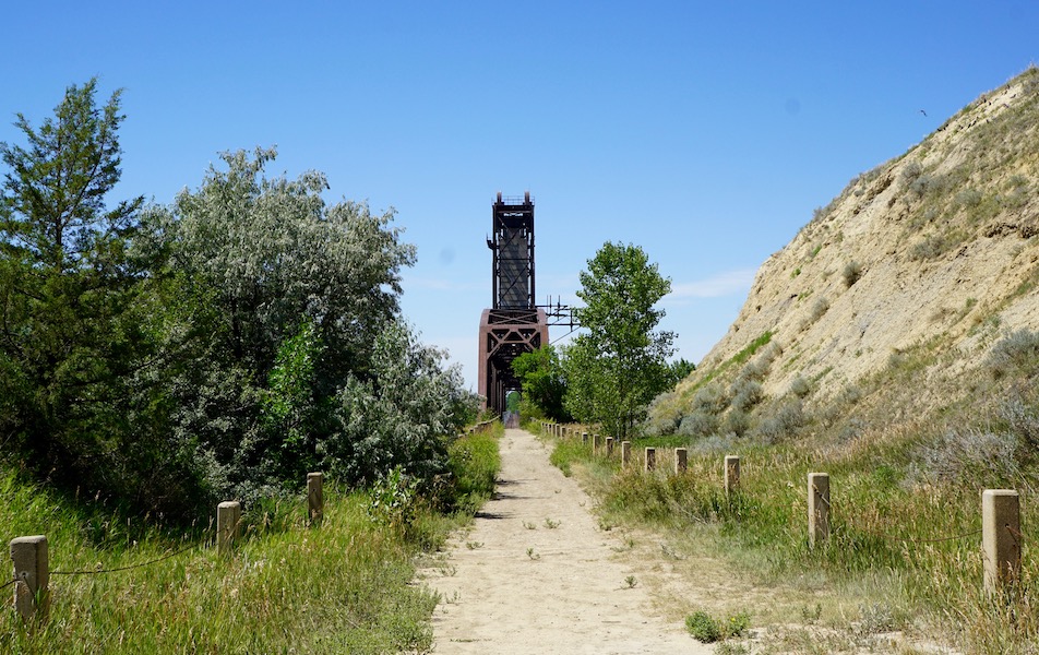
County: McKenzie
A unique rail-trail experience awaits in the far western reaches of the state, where a historic abandoned railroad lift bridge serves as a walkway between North Dakota and Montana. Although short, at just a mile, the Fairview Bridge & Cartwright Tunnel packs a lot of history and scenery into its route across the Yellowstone River.
The lift span on the Fairview Bridge was raised only once—in 1914—as a test shortly after the bridge, a part of the Great Northern Railroad for its never-completed Montana Eastern Railway—was built. The lift reportedly was already obsolete when construction got started in 1913. By then, commercial traffic on the Yellowstone River had mostly ceased.
Today, the bridge—which measures 1,320 feet long and hangs 100 feet over the water—is listed on the National Register of Historic Places. After crossing the bridge, adventurous trail users can venture into the 1,456-foot-long Cartwright Tunnel, which was built in 1912 and 1913. Bordered by Fairview, Montana, in the west and Cartwright, North Dakota, in the east, the bridge is a 15-minute drive to the Fort Union Trading Post National Historic Site, known to have been the most important fur trade post on the Upper Missouri River throughout the mid-1800s.
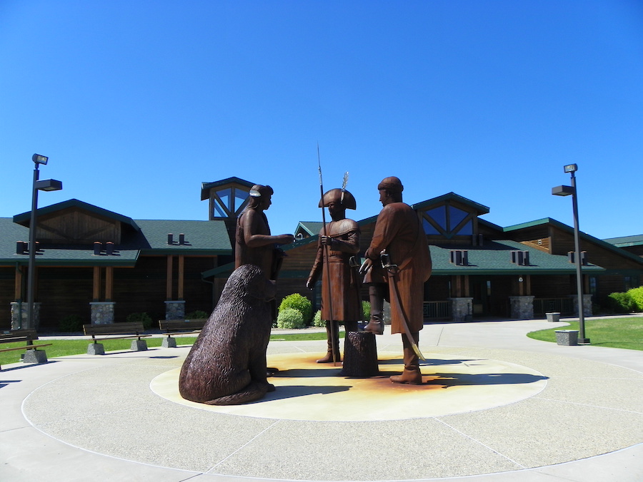
Missouri Valley Millennium Legacy Trail
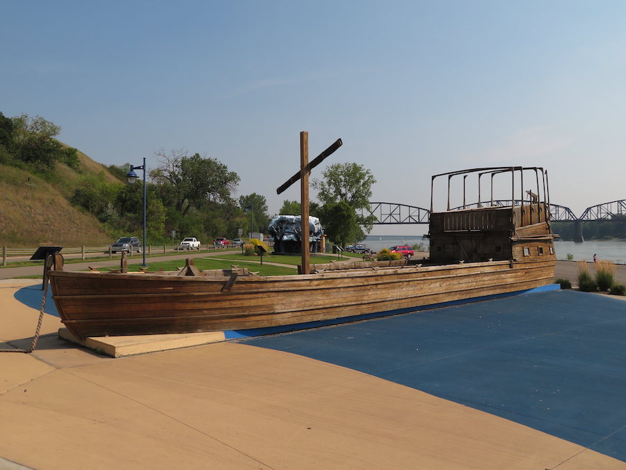
Counties: Burleigh, Morton
Another significant moment in history played out not far from the Missouri Valley Millennium Legacy Trail that straddles the cities of Bismarck and Mandan. It was in the area along the mighty Missouri River that Meriwether Lewis and William Clark are said to have met up with Sacagawea, the Shoshone woman who would serve as an interpreter and guide as the Corps of Discovery Expedition continued its westward trek in the early 1800s.
Today, the 4.6-mile trail offers a green, leafy route along the riverfront. It passes by a number of parks, including Keelboat Park with a 55-foot replica keelboat like the one used by Lewis and Clark, Steamboat Park, where trail users can enjoy views of the Missouri, known as the Big Muddy, and the Lewis & Clark Riverboat.
Burlington Walking Path
County: Ward
Rolling countryside is on display on the 5-mile Burlington Walking Path that connects the north-central city of Minot with the small town of Burlington to the west. The mostly flat, paved trail is perfect for walking, running, rollerblading or cycling.
Along the way, the trail passes nearby the confluence of the Des Lacs and Souris rivers. It features two covered shelters with park benches and outdoor fitness equipment. From the trail’s end in Minot, walkers and cyclists can continue onto the sidewalk along Fourth Avenue to the pretty Oak Park, a recreation area that features restrooms, picnic shelters and walking paths.
Nux Baa Ga Trail
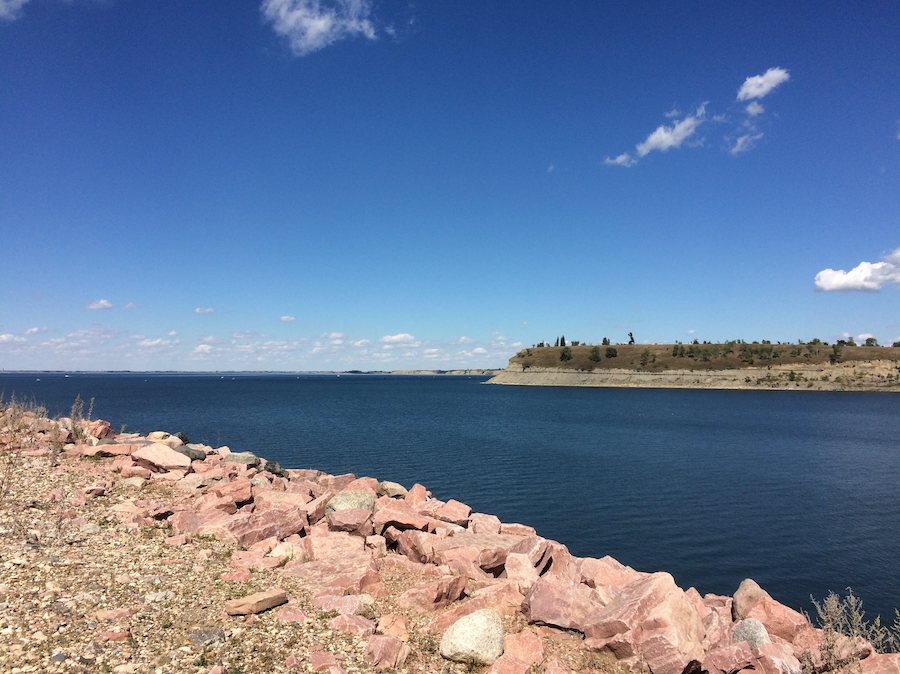
County: McLean
For a close-up look at the third-largest manmade lake in the United States, head to the Nux Baa Ga Trail, a relatively new mountain-biking route that follows the shores of west-central North Dakota’s Lake Sakakawea (an alternate spelling for Sacagawea).
A part of the Lewis and Clark Legacy Trail System, Nux Baa Ga (meaning “All the People” in Arikara) winds for about 6 miles along the shores of the reservoir that was impounded by the Garrison Dam in the Missouri River basin. The single-track dirt trail is suitable for cyclists, hikers and horseback riders. The trail can be accessed at the trailhead at the Indian Hills Campground, located about 30 miles west of the small town of Garrison.
Plenty of other recreational opportunities are available nearby as well, at the Lake Sakakawea State Park and the Fort Stevenson State Park.
Northern Cass Pass
County: Cass
A route that once carried trains on the Casselton-Mayville Railroad now provides a place for leisurely biking and walking between the small Red River Valley towns of Hunter and Arthur. For 6 miles, the asphalt and gravel Northern Cass Pass provides a straight and flat recreational route through the prairieland north of Interstate 94. The rail-trail was once on the line of the Great Northern Pacific Railroad, later the Burlington Northern. In 2012, the railroad rails and ties were removed, and the communities of Hunter and Arthur worked to repair the railroad bridges, plant native trees, and compact the trail’s surface. Much of the trail was later paved.
A ride or a walk along the Northern Cass Pass makes a great day trip from Fargo, the state’s largest city, located about a half-hour to the southeast.
Washburn Discovery Trail
County: McLean
Another tie-in to the route that explorers Lewis and Clark took through North Dakota is available at the Washburn Discovery Trail, a 2.2-mile concrete path that begins at the state’s Lewis & Clark Interpretive Center and continues along the bank of the Missouri River.
The trail, which is a certified Lewis & Clark National Historic Trail site, provides sweeping vistas of the river, as well as views of historic sites such as the last operating ferry boat on the river in North Dakota, the historic Washburn Landing and the Soo Line Railroad. On the eastern end, a section of the trail parallels an active railroad, earning it a rail-with-trail designation. The Discovery Trail is intended for walking, running, bicycling, skating and skiing. It also is suitable for wheelchair access.
The trail is located in the scenic river town of Washburn, the starting point for the Sakakawea Scenic Byway and home of the Cross Ranch State Park.
Tatman Branch Trail
County: Ward
A rail-trail that dates back 135 years to a spur of the Great Northern Railroad now features 10 miles of unimproved recreational rail bed north of the community of Minot. Beginning at the outskirts of town, the gravel bed of the Tatman Branch Trail ends at the main entrance to the Minot Air Force Base.
The construction of the Great Northern Railroad in 1886 reportedly spurred the founding of Minot, North Dakota’s fourth-largest city. Today, the trail follows the flat, straight railroad route through classic prairie countryside.
Pipestem Creek Trail
County: Stutsman
Located about 4 miles north of the central North Dakota town of Jamestown, the Pipestem Creek Trail is renowned for its rugged and scenic mountain biking trails. The Pipestem Creek Trail runs for about 8 miles and is part of a larger 35-mile system of trails near the Pipestem Dam.
The trails wind in and out of hills, forested areas and prairielands that surround the Pipestem Dam, located northeast of Jamestown. The system of trails features a combination of paved, unpaved, short, long, easy or challenging trails. The Pipestem Creek Trail is home to the popular Gear Grinder Mountain Bike Race.
Honorable Mention
The 4,700-mile North Country National Scenic Trail stretches across eight states in the northern United States—including 440 miles in North Dakota, where it follows the Sheyenne River, from the Ekre Grassland Preserve in the east to the Lonetree Wildlife Management Area in the west. Much of the trail crosses native grasslands, grazed pastures and woodlands, while about 40% temporarily follows public roads as the trail organizers work to secure access and develop new off-road sections.
When you subscribe to Rails to Trails magazine, you’ll have access to many other features like this one. Our magazine is a premium of Rails to Trails membership. Join today to start receiving the magazine!

Donate
Everyone deserves access to safe ways to walk, bike, and be active outdoors.
Related
View All
Safe by Design: Examining the Impact of Trails and Bike-Ped Infrastructure on Safety in America
Exploring the Nation’s Trailside Geoheritage Sites