Colorado: Exploring the Colorado Riverfront Trail
This article was originally published in the upcoming Winter 2022 issue of Rails to Trails magazine. It has been reposted here in an edited format. Subscribe to read more articles about remarkable rail-trails and trail-networks while also supporting our work.
Grand Junction, Fruita and Palisade may be the Holy Trinity for outdoor lovers everywhere. More than a million acres of public land surround the three communities. Folks visit from around the world to bike, hike, swim and otherwise revel in its wealth of activities every year. Seemingly every fifth vehicle is a sprinter van with bikes loaded on the back. Almost everyone looks like a model for an REI ad.
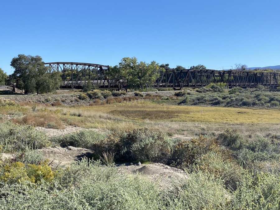
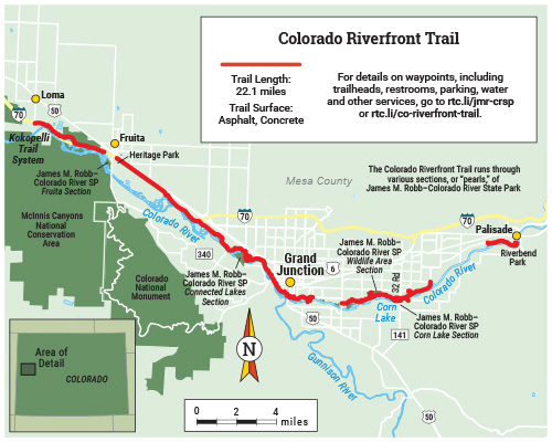
I was in town primarily to explore a relatively thin strip of those public lands, the 22-mile Colorado Riverfront Trail. The Riverfront Trail is actually a conglomeration of multiple (mostly) connected trails that join the trio of communities along with state parkland—including four of the five separated sections of James M. Robb–Colorado River State Park, known locally as a “string of pearls,” and several community parks. Although the riverfront doesn’t have much of a rail history, it acts much like the railroads did more than a century ago—connecting the community, allowing people to get where they needed to go quickly and conveniently.
The plan was to split the ride between two days: The first day I’d explore most of the west end of the trail from Fruita to Grand Junction on my Trek Domane road bike, while the second day I’d tool around on a borrowed Priority Current e-bike, taking in Palisade and the surrounding environs.
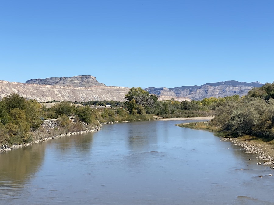
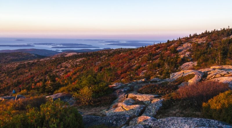
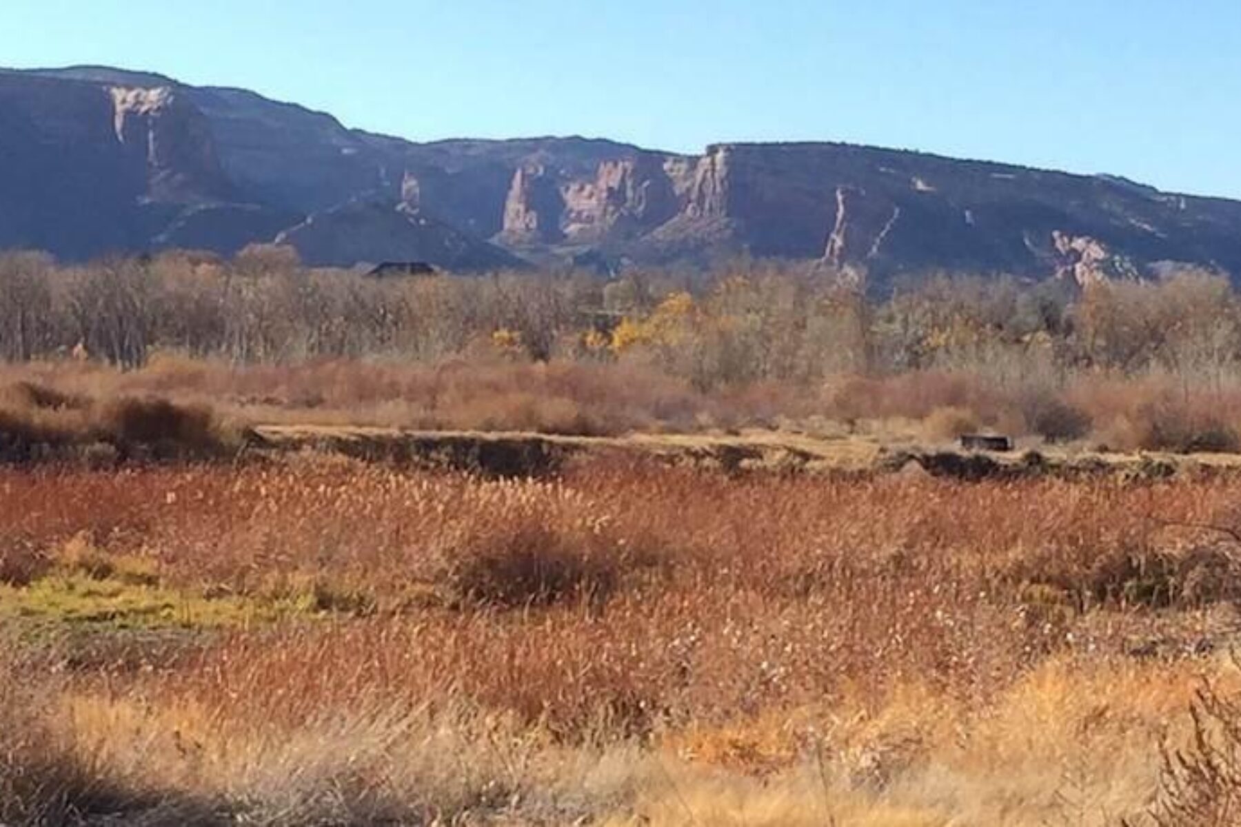
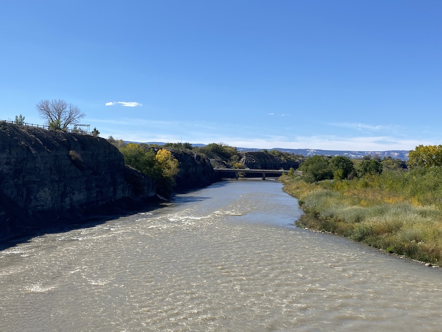
Surrounded by the Colorado National Monument to the southwest, the Book Cliffs Mountain Range to the north and the Grand Mesa to the east, the trail has many views with a dramatic granite or sandstone backdrop. Rolling out from Heritage Park near the Fruita Visitor Center, I was dumbstruck by the mountains on either side of the aptly named Mountain View segment of trail. It barely registered to me that it also paralleled Interstate 70 with the ensuing highway traffic and noise.
After that came the Connected Lakes section of James M. Robb–Colorado River State Park, along which the aspens were just starting to turn from green to lush gold. Quite a few fishermen had lines in the water. Pedaling along, I noticed a hiker looking up in a tree. He noticed my curiosity as I was about to ride past, and simply said, “bald eagle,” and pointed upward. Sure enough, there was an adult eagle perched majestically in a pine, surveilling the landscape. I was so focused on what was around me, I wasn’t paying enough attention to what was above me.
The trail passes by multiple small parks—terrific stops to refill a water bottle or take a brief respite. Grand Junction apparently loves its disc golf; there were at least two disc-golf courses along the trail, both filled with cheerful participants flinging plastic discs around. There was also a pump track, where young singletrack riders were launching off dirt ramps or learning to balance on wooden skinnies.
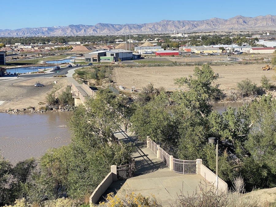
While there are restrooms and ample parking along the trail, you do have to detour slightly in order to grab lunch or a cup of coffee … for now. Luckily, downtown Grand Junction lies maybe 2 miles off the trail along a bike lane and offers a host of refreshment options, including a few microbreweries and craft beer bars. Development is building up around the trail, however, including a new luxury “glamping” campground called Sky Outpost slated to open within the next year or so as well as a Mexican cantina.
My main, and perhaps only, gripe against the trail was the lack of signage for road detours. When the trail essentially dead-ended at Eagle Rim Park at the midway point, I wasn’t able to find the right road connection to continue on. It wasn’t until I was nearly back to my van that I remembered the TrailLink app on my smartphone. It would come in very handy the next day.
Had I continued on the Riverfront Trail farther west, the newest section of the trail would have taken me to the world-famous Kokopelli mountain-bike trail system, where I could ride the singletrack to my heart’s delight and theoretically even ride all the way down to Moab, Utah. I was tempted, but given how little time I’ve spent on my Trek Fuel EX the last couple of years, I was a bit nervous about making the return trip on a potentially busted collarbone or broken hand.
On day two, I started in Palisade Riverbend Park. About two minutes after leaving the path, I was already lost, as a large chunk of the trail is missing around 29 Road to C½ Road. Yes, many of the roads in Palisade are numbered or lettered and use fractions, which seems to be a good system unless you’re as bad at algebra as I am. Doing the mental division in my head, I would be halfway through carrying the 1 when I realized I’d already passed my intended turn about 2 miles before. Luckily I was able to use the TrailLink app to find my way back on course.
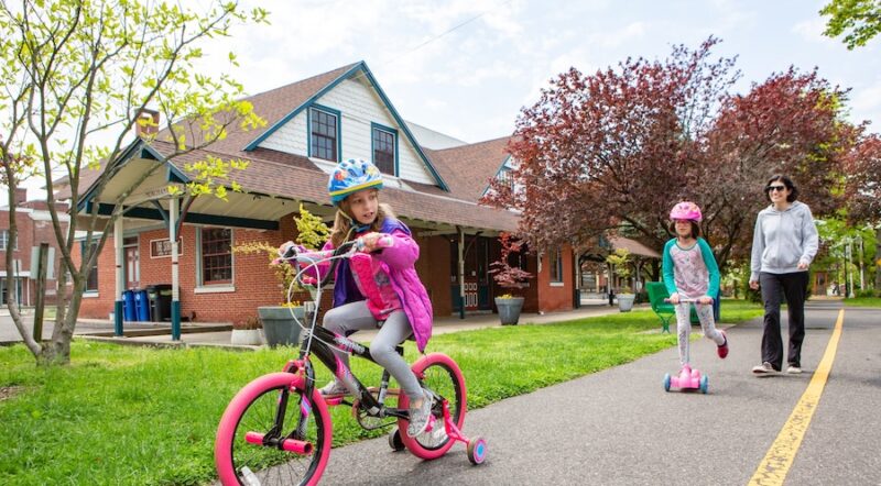
Just like the day before, the trail was packed with users. Elderly couples walking tiny dogs, riders pedaling to a trailhead, families strolling from one park to another; disparate groups of people, but everyone seemed to be smiling from ear to ear.
Abutting the water in James M. Robb–Colorado River State Park stands a small granite bluff, the home to multiple species of cliff-dwelling birds, like the cliff swallow, spotted sandpiper and common nighthawk. But along the trail, natural beauty isn’t the only thing to keep an eye on; there’s plenty of public art, including a lovely sculpture of geese and colorful underpass murals.
Around 33½ Road, I entered the Fruit & Wine Byway. While nearly all of the fruit stands were closed that Sunday, most of the wineries were open and pouring. It would be bad journalism if I didn’t stop into at least one or two.
Nestled along the acres of grapevines, Colterris Winery was the ideal spot to take a break and sample a few different vinos. The Malbec was a particular favorite, but that’s also coming from someone who knows literally next to nothing about wine. You could mix grape jelly and rubbing alcohol together, and I’d still admiringly sip it and comment on its robust bouquet. Unfortunately, I knew I had to pedal back to my home on wheels, so I couldn’t get tipsy.
The roads around Palisade were deceptively hilly, and I was glad to have the e-bike to help me motor up the inclines. But sadly, it also meant the ride was over much too soon.
Getting There Located about 5 miles from the city center, Grand Junction Regional Airport is serviced by most of the major airlines, including United, American, Frontier and Delta.
Where to Eat and Drink
A mile or 2 from the Riverfront Trail and the Fruita Visitor Center, Mi Ranchito Taco Shop offers the best tamales I’ve ever eaten, handmade by the owners’ grandmother. As an added bonus, the food is insanely affordable. The interior ambiance is simple and basic, but who cares? You’re there to eat and talk about your adventure on the trails! The Handlebar Tap House, with a couple dozen rotating craft taps, seemed like a fitting place to go after a ride. The beer was cold, and the burger-heavy menu offered basic bar food, but was still tasty. Colterris Winery along the Fruit & Wine Byway—which is connected to the Riverfront Trail—is a great place to pitstop and sample some tasty vintages.
Where to Stay
Whether you’re traveling by RV or staying in a hotel, you have nearly unlimited choices (with more seemingly popping up by the month). I parked my camper van at the North Fruita Desert Camping Area, a large open area with individual sites with firepits and picnic tables managed by the federal Bureau of Land Management. Multiple mountain-bike trails leave from the site. You’ll find most of the usual chain hotels in and surrounding Grand Junction. If you’re looking for something a little different or just don’t want to stagger too far away from the tasting room, Two Rivers Winery and Chateau offers rooms from $92 a night.
What to See
So what to do after taking in the Riverfront Trail? The Fruita/Grand Junction area—with sites like Kokopelli’s Trail—is widely regarded as one of the best places in the world to ride a mountain bike, and there are plenty of places to hike or gaze at wildlife in the Colorado National Monument. During the summer, you can take in Fruita’s Rim Rock Rodeo each Tuesday or find a band playing somewhere in town.
Where to Rent
I detoured to Brown Cycles in downtown Grand Junction during my ride because of a loose cassette. The two friendly employees were quick to give me a hand and charged only $5 for their time and effort. They offer a wealth of rental options, from cruisers to road bikes to full-suspension rigs. The shop is maybe a mile or 2 from the Riverfront Trail, connected via a bike lane.
James M. Robb–Colorado River State Park
Colorado River State Park was renamed for James M. Robb in 2005 to honor the visionary who was instrumental in its creation. Robb dubbed the park’s five distinct sections a “string of pearls.”
For more info on James M. Robb–Colorado River State Park, click here.

Donate
Everyone deserves access to safe ways to walk, bike, and be active outdoors.
Related
View All
New England Rail-Trail Leader Alex Bernhard Passes Away at 89
Safe by Design: Examining the Impact of Trails and Bike-Ped Infrastructure on Safety in America