Leveraging Data to Advance Equitable Planning and Development
30th Street corridor in Milwaukee, Wisconsin | Photo courtesy RTC
Data can be a powerful tool to advance equity in trail planning and development. A wide range of data can be used by trail and active-transportation planners to understand the physical, economic and social landscape of communities. In particular, spatial data that examines racial patterns of inequality can guide more equitable planning decisions and bring communities together around a common understanding to drive change.
Increasingly, planning agencies and trail groups are utilizing and creating equity metrics in order to decide which projects get priority, as well as to measure their potential impacts. However, these things are yet to be standard practice, and much more is needed to fully realize equitable planning practices and outcomes.
- The Milwaukee Parks and Recreation Board incorporates racial and economic equity criteria to guide the selection of regional park and trail capital projects. The board scores each project based on a combination of community characteristics (race + income, park access, neighborhood safety) with park criteria (trail quality, accessibility, acreage) to work out where the needs are greatest.
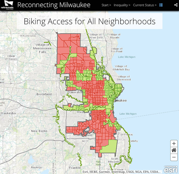
- BikeAble™, a connectivity analysis tool developed by RTC, uses GIS modeling to measure the ability of people in specific areas to access destinations within low-stress bicycle routes. The tool was developed with the recognition that for people to even access trails, their wider transportation networks must also be conducive to safe biking. Using BikeAble, planners are able to analyze possible improvements—such as adding a trail—against current infrastructure and travel patterns; evaluate the impact on the overall connectivity of the network; and prioritize future investments. An example of our equitable connectivity work using this tool is summarized in a recent study by RTC, “Reconnecting Milwaukee: A BikeAble™ Study of Opportunity, Equity and Connectivity.” The study—which explored access in the city of Milwaukee for bicyclists and pedestrians to employment centers and schools—found that neighborhoods experiencing inequality (predominantly Black and Hispanic, low-income and zero car households) had disproportionately lower access to safe walking and bicycling facilities. The study went on to analyze the impact of two proposed trail projects (on levels of access to trails) and found that they would significantly increase access for all residents. Across the city, bicycling access would increase from 24% to 59%, and in neighborhoods experiencing inequality, that access would increase from 8% 66%—ultimately taking the number of residents who have access to trails from 25,000 to 200,000.
- Esri, developers of GIS mapping software, have provided the Racial Equity GIS Hub, a collection of tools including datasets, maps, applications, training resources, best practices and examples from users that are using GIS to visualize, analyze and address racial inequities.
- This blog post by the Transportation Research Board contains links to research reports, journal and news articles, events and webinars to help transportation researchers, practitioners and policy makers improve safety and equity for pedestrians. The TRB is a division of the National Academies of Sciences, Engineering, and Medicine that promotes innovation in transportation through high-quality research and information sharing.
Data is a powerful tool that can illuminate systemic and structural inequalities that are disproportionally faced by People of Color. It’s important to remember, however, that while data is extremely important, it should not stand alone to drive decision-making in any planning process. Rather, data should be bolstered by engaging with folks on the ground in neighborhoods and communities, and valuing their stories, to ensure a true understanding of how the data truly reflects the lived experiences of residents.
Rails to Trails Conservancy’s Trail Equity Research
At Rails-to-Trails Conservancy (RTC) we realize the importance of promoting equitable and inclusive trail development. To that end, our research agenda prioritizes original research that contributes to the field in significant ways.
Trails, Property Values and Gentrification
Our review of existing trail and gentrification literature revealed insufficient evidence of the impact of trails on property values. Most studies show some amount of correlation (A is related to B, but not A causes B) between trails and increased property values within a certain distance from trails, but none have dissected the role of trails in affecting that change. In order to learn more about the impacts of trails on property values, RTC engaged in a research study looking at three trails across the country (the Metropolitan Branch Trail in Washington, D.C.; the Lafitte Greenway in New Orleans, Louisiana; and the Shelby Farms Greenline in Memphis, Tennessee) and analyzing their impact on surrounding multifamily rents and housing values. The results reinforce previous research results that trails are heterogeneous, their effects are context-dependent and may be highly localized, especially outside of high-cost markets.
RTC aims to not only promote the positive impacts of trails in raising home values, but also the best practices needed to mitigate the negative impact of rising rents and values on historically marginalized populations—specifically those that would prevent or minimize the social, economic and cultural displacement of existing populations. With this in mind, RTC, with researchers from Johns Hopkins University conducted a thorough literature review of affordable housing best practices around trails.
Barriers to Active Transportation
In 2018, RTC conducted a nationwide survey to identify factors affecting people’s trail use. Knowledge and awareness of trails, and access to trails, were the two most important factors that came out on top. Since over 95% of the survey respondents were White, the survey did not fully capture the barriers and motivators for trail use for People of Color. In order to address that shortcoming, RTC engaged in a second phase of national data collection in May 2020, oversampling Black and Latinx populations to gain a better understanding of the barriers that different groups face and need to overcome in outdoor spaces. RTC also collected data from four metro areas (the Bay Area; Cleveland, Ohio; Miami, Florida; and Washington, D.C.) to understand the regional similarities and/or differences of opportunities and perceptions that might exist.
RTC is also partnering with the Johns Hopkins School of Public Health to study the perceptions of, motivations for, and barriers to active transportation infrastructure among the residents of two Baltimore neighborhoods. This project is part of the Bloomberg American Health Initiative, which aims to address critical 21st-century challenges to public health through education, research and practice.
Resources
‣ Webinar – Barriers to Trail Use
‣ Webinar – Trail Networks and Housing Stability
‣ Press Release – RTC Study: Milwaukee Residents Who Could Benefit Most from Biking and Walking Facilities Disproportionately Lack Access
‣ Article – Neighborhood Change and Gentrification Near Three Urban Trails
‣ Article – Strategies to Preserve and Build Affordable Housing Near Green Amenities and Urban Trails
‣ Factsheet – Glossary of Terms Relating to Equitable Trail Development
TrailNation Collaborative
TrailNation™ Collaborative is a nationwide peer learning community from Rails to Trails Conservancy that brings together advocates, leaders and professionals from across disciplines to establish and accelerate trail networks across America. The collaborative provides proven tools, methods and resources, combined with RTC’s expertise and network of partners across the country, to accelerate the development of connected trail systems. When trails are connected across regions and states, trail networks have a proven transformative impact—they are essential infrastructure that creates thriving, healthier communities.