Trails and Transit
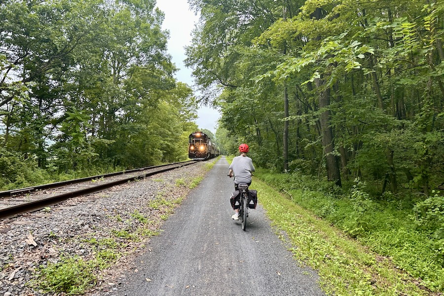
Delaware & Lehigh Trail | Photo by Thom Carroll
In communities across the United States, planners are integrating public transit with multiuse trails to make commuting safer, more seamless and truly multimodal. Transit and active transportation complement each other, as commuters often walk or bike to transit stations, and then from transit to their final destinations, forming essential first-mile and last-mile connections. An analysis of survey data from 163 transit systems across the United States found that 69% of respondents walked to transit stations or stops, while 73% walked from transit to their final destination.
The success of a transit system is closely tied to the quality of these connections. Multiuse trails offer safe, convenient pathways to and from transit, strengthening the overall network. Additional synergies between transit and walking or biking include:
- Increased ridership: Trails and other active transportation amenities provide safe access to transit stations, encouraging more people to use transit.
- Expanded reach: Biking can extend the service radius of transit, connecting areas beyond typical walking distance. The walkshed, or distance that pedestrians are willing to travel to transit stops, is between one-quarter and one-half mile, whereas the bikeshed is between 1 to 3 miles.
- Longer-distance travel: Cyclists and pedestrians can use transit to cover greater distances, combining modes for efficiency.
- Equitable mobility: Transit, walking and biking offer affordable access to everyday destinations such as work, school, grocery stores and medical centers. This is especially important for those who cannot drive or lack access to a personal vehicle, including older adults, children, people with disabilities and low-income individuals.
- Multimodal flexibility: Commuters can choose the mode that best suits their needs—walking, biking, transit or a combination—potentially replacing car trips and reducing congestion.
- Health benefits: Transit use is associated with more walking, fewer vehicle-miles traveled, lower emissions and reduced crash risk. Walking and biking are active modes that promote physical health.
- System resilience: When transit is congested or offline, or simply by choice, commuters can walk or bike instead. This is especially true for rail-with-trail systems, where trails run parallel to transit lines and offer built-in redundancy.
According to APTA, there are several dimensions of cycling integration with transit:
- At transit—providing secure bike parking and storage at stations or stops
- On transit—allowing bicycles on board buses or trains
- With transit—locating bikeshare stations at or near transit stops, which can augment or complement transit.
- To transit—on- and off-street facilities that commuters can safely and conveniently use to get to and from transit stations. Multiuse trail networks may increase the level of comfort and encourage use for cyclists who might otherwise be reluctant to share space with cars to get to transit.
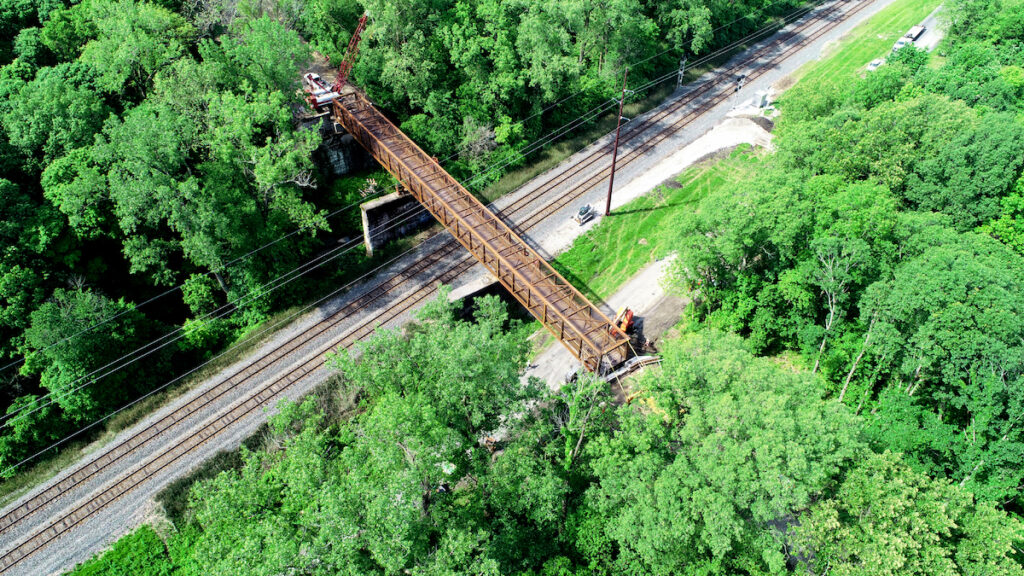
Rails-with-Trails
Trails can also be situated alongside transit-fixed rail infrastructure. In this way, they act as an alternative to transit, while still providing access to stations and destinations along the way. The 2021 Federal Highway Administration (FHWA) report, “Rails-with-Trails: Best Practices and Lessons Learned,” found that the share of rail-with-trails being built along passenger transit lines had increased with time, as opposed to those located along freight lines. This is because municipalities, regional governments and transit agencies are more likely to see rails-with-trails and bike-ped infrastructure as part of a wider multimodal transport system and as a boost to transit. The report also recommends that rails-with-trails be designed to promote safe and accessible connections to transit, where possible.
Planning Transit with Trails
Planning for trails with transit requires collaboration across key stakeholders, given that the players hold different roles and jurisdictions. Whereas transit agencies can consider bicycle and pedestrian access as they plan routing and stations, it is generally the work of the municipality or county to build and maintain the active transportation infrastructure that connects to, from and between stations.
Regional planning organizations will help with coordination and planning, ensuring that region-wide and long-term views are taken for these projects, that there is cross-jurisdictional collaboration, that there is community engagement and buy-in, and that impactful projects are prioritized for funding in the Transportation Improvement Plans (TIPS).
The roles are not always this discrete. Sometimes a transit agency is housed within a municipality or regional government. Other times, they are standalone agencies but include trails as part of their capital improvement projects. A transit agency may even be explicitly mandated to provide both transit and trail/bike-ped services. The Roaring Forks Transportation Authority (RFTA) in Colorado was established in 2001, in the years following the railbanking of the 42-mile Rio Grande Trail. The RFTA acts as the unified authority that receives and allocates funding (primarily from designated local transportation taxes) to support both transit operations and trail development/maintenance throughout the Roaring Forks Valley.
Walkability and bikeability are also central to transit-oriented development (TOD), which seeks to cluster residential, office, retail, entertainment and vibrant public space within a given radius of a transit station. By integrating land use and transportation in this way, the goal is to create connected and convenient communities, where people can walk, bike or take transit to where they need to go, reducing dependence on cars. This also has benefits at the farebox, increasing ridership and revenues for transit. Public transit agencies are often advocates and stakeholders in TOD planning. For example, in the Greater Washington, D.C., region, the Washington Area Metropolitan Transportation Authority (WMATA) has published a Station Area Planning Guide to provide design guidance for station site and access planning to create high-quality, transit-oriented communities.
Safety is key when it comes to integrating trails, walking and biking with transit. The public transit agencies interviewed for the 2021 FHWA “Rails-with-Trails” report generally required some kind of fencing or separation between trail and the tracks. And while their goal is to limit the number of at-grade crossings—where these crossings existed, the agencies employed safety measures like warning signs, gates and Z-crossings to encourage trail users to look both ways.
Funding
Trail projects are generally funded using a combination of federal, state, local and private sources. When combined with transit, this opens up even more options, including funding from the Federal Transit Administration (FTA). Multimodal projects funded by the FTA must provide access to transit within a certain radius of a transit stop or station (Within 3 miles for bikes, and 0.5 mile for walking). Bike-ped projects including trails may be eligible for formula funding under the Urbanized Area Formula Grants and Non-Urbanized Area Formula Grants programs. Other FTA programs provide money for planning; for instance, the FTA Transit Oriented Development (TOD) pilot program provides grants for projects that improve access to transit and affordable housing.
Examples
A-Train Rail Trail (Texas)
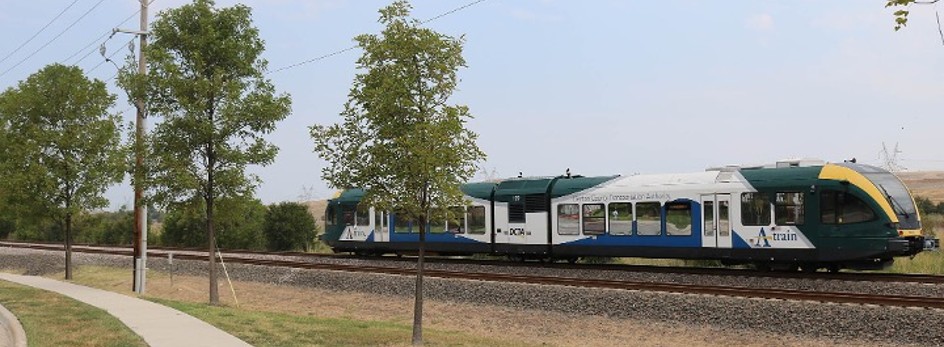
The A-Train Rail Trail is a rail-with-trail running alongside its namesake commuter rail line. The 19-mile concrete multiuse trail connects downtown Denton—a vibrant college city on the edge of the Dallas-Fort Worth Metroplex—to Lewisville, a closer-in suburb. The trail was built on the former MKT railroad right-of-way, which was acquired by the City of Denton in the 1990s, and was built in conjunction with the commuter line. The first 9 miles (known as the Denton Branch Rail Trail), which were completed in 2011, were funded using a combination of local funds and integrated as part of the commuter line’s construction. Subsequent phases were built using federal funds as part of the expansion of Interstate 35E. Overall, the trail cost $14 million to build.
The rail-with-trail provides access to five A-Train stations and key destinations including schools, neighborhoods, health-care centers and retail. The Denton County Transportation Authority (DCTA), which operates the commuter line, views and markets the trail as an integral and complementary part of the system. The proximity and connectivity that the trail provides makes it incredibly popular (3.2 million trips have been reported in one year) because users can conveniently mix trail and train commuting. For example, a person may choose to bike to one end of the trail and then board the train back. The trail is also part of the North Central Council of Government’s (NCTCOG) regional bike vision, known as the Regional Veloweb.
The Metropolitan Branch Trail (Washington , D.C.)
The Washington Metropolitan Area Transit Authority (WMATA) manages a system of rapid transit (Metrorail), fixed-route buses (Metrobus) and paratransit (Metro Access) in the Washington, D.C., region, which includes counties in southern Maryland and northern Virginia. It’s an extensive and well-used system; Metrorail (usually just called “the Metro”) spans 130 miles with 6 lines and 98 stations, and is one of the country’s busiest rapid transit systems.
WMATA allows bikes on trains at all hours, and there are external bike racks on the front of Metrobuses. At Metro stations, various kinds of bike parking exist, including bike racks and bike lockers. Bikeshare stations are often sited at or close to metro stations. There are also metro rail and bus stations that are accessible via trail. A leading example is the 8-mile Metropolitan Branch Trail, which runs adjacent to rapid transit, freight and commuter rail lines, and provides direct walking and biking access to a number of metro stations in northeast Washington, D.C. WMATA recognizes the trail as a way to enhance transit ridership, safety and access. The rail-trail is popular with commuters and recreationists alike as a conduit between the Metro and the vibrant neighborhoods, local attractions and events, parks and commercial destinations.
Read more: Top 10 Trails in Washington, DC
Madison County Transit Trails (MCT Trails) and St. Clair Transit County District MetroBikeLink (Illinois)
Located in the Metro East/St. Louis metropolitan area, the Madison County Transit Trails system (MCT Trails) is an extensive network of paved trails intertwined with bus transit, connecting communities and natural areas in Madison County. While the MCT provides fixed-route bus and paratransit services, trails are viewed as a logical extension of their mission, since most trips start and end with walking (or biking). Thus, they’ve made every effort to create a system where people can seamlessly combine walking, biking and bus trips. In addition to the trails, all buses are equipped with bike racks, and there are multiple park-and-ride locations, where commuters can park for free and easily get on a bus or trail.
The trail system started to take shape in the early 1990s as an attempt to preserve the county’s numerous railroad corridors for future light rail, and as interim trails. Today, the system’s 12 rail-trails extend nearly 140 miles and connect more than 20 communities across the county.
While MCT is the owner of the rights-of-way and concerned with planning, policy and capital funding, the trail system is actually built and maintained by the Agency for Community Transit (ACT), the MCT’s nonprofit partner, which also operates the bus and paratransit services. Since the trail network’s inception, over $45 million has been invested into the trails from a combination of federal, state and local sources, as well as the MCT and the Metro East Park and Recreation District (MEPRD).
The MCT trail system ventures into neighboring St. Clair County, where their transit district has similarly invested in a 40-mile off-street bikeway network, christened MetroBikeLink, to complement its MetroLink (light rail) and MetroBuses. The spine of the system is the 14-mile MetroBikeLink Trail, which runs adjacent to the light rail and connects to several stations. The St. Clair County Transit District owns, manages and operates the trails in the MetroBikeLink system. Bikes can be brought on MetroLink, and all Metrobuses are equipped with exterior bike racks.
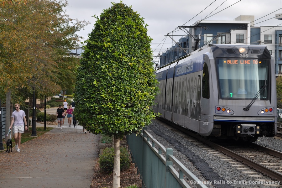
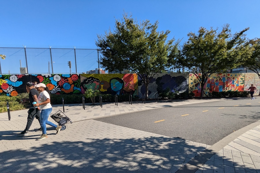
Charlotte Rail Trail (North Carolina)
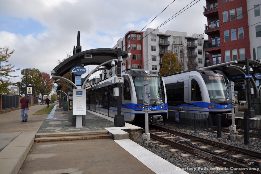
Charlotte’s LYNX Blue Line has been one of the most transformative urban projects in the Queen City. The light rail line runs along a former freight rail corridor that the city purchased in the 1990s—a moment of foresight that laid the groundwork for their modern transit system. The first phase of the Blue Line opened in 2007, marking the debut of rapid rail service in North Carolina. Today, the line stretches nearly 20 miles, from the University of North Carolina at Charlotte and through the NoDa neighborhood (named for its main thoroughfare, North Davidson Street), Uptown and South End. It continues south along South Boulevard to its terminus just north of Interstate 485 at the Pineville city limits.
The presence of the transit line has revitalized the neighborhoods it passes through, and thanks to thoughtful planning, Charlotte has successfully leveraged transit-oriented development (TOD) to shape growth along the corridor.
The Charlotte Rail Trail began as a maintenance path for a short-lived, refurbished trolley line. Now, it runs adjacent to the Blue Line, offering a vibrant pedestrian and bike corridor that connects homes, restaurants, gyms and businesses directly to transit. Nine of the Blue Line’s stations are accessible from the trail, including the Charlotte Transportation Center, which serves as a central hub for both bus and rail services. Bikes are also allowed on LYNX trains.
Public and private collaborations have been key to the trail’s success. Over time, the rail-trail become a catalyst for new commercial and residential development. Charlotte is a leading example of how TOD can be combined with trail-oriented development (TrOD). The city plays a central role in planning and filling gaps along the trail and requires developers along the corridor to orient buildings toward the trail and light rail. As Jason Lawrence, director of planning for the Charlotte Area Transit System (CATS), explained in an article on RTC’s Trailblog: “We require apartments [built in the corridor] to have a doorway to it …. It’s not the back of the house—it’s a front door. This encourages it to be an active space.”
Day-to-day maintenance of the trail is handled by CATS, while Charlotte Center City Partners manage programming, including public art installations, pop-up businesses and community events. These efforts create a welcoming public realm that invites people to explore, gather and linger.
“Public transportation is about more than buses. Part of transit is connecting people to and from transportation hubs. [The Central Ohio Transit Authority’s] transit improvement investment goes beyond vehicles to create more local infrastructure like bikeways, greenways, sidewalks and trails that not only improve connection to COTA stops across the region, but make it easier to walk and bike in your community.”
—Central Ohio Transit Authority
LinkUS is Central Ohio’s regional transportation and growth initiative, with an aim to modernize and expand transit service while simultaneously growing the region’s bicycle and pedestrian infrastructure. The $8 billion-plan is an initiative of the Central Ohio Transit Authority (COTA), along with the City of Columbus, Franklin County Board of Commissioners and the Mid-Ohio Regional Planning Commission (MORPC). In 2024, Columbus voters approved a ballot measure to double the sales tax to 1%, which will unlock $6 billion in funding to COTA by 2050 to implement the improvements.
Planned improvements to transit include five new bus rapid-transit lines (BRT), as well as service and station improvements. At the same time the plan seeks to double the current levels of investment in trails, walking and biking to $60 million annually. This will create a 500-mile network of safe bike-ped facilities that connect to each other as well as to transit stops. The increased access and connectivity will go a long way to creating more walkable and bike-friendly neighborhoods.
Resources
‣ Report – FTA Manual on Bicycle and Pedestrian Connections to Transit (2017)
‣ Report – Bicycle and Transit Integration Guide (APTA)
‣ Report – Integrating Transit, Bicycling and Micromobility in Northern Virginia (2025)
‣ Report – Rails-with-Trails: Best Practices and Lessons Learned (2021)
‣ Plan – MCT Trails Master Plan (2024)
TrailNation Collaborative
TrailNation™ Collaborative is a nationwide peer learning community from Rails to Trails Conservancy that brings together advocates, leaders and professionals from across disciplines to establish and accelerate trail networks across America. The collaborative provides proven tools, methods and resources, combined with RTC’s expertise and network of partners across the country, to accelerate the development of connected trail systems. When trails are connected across regions and states, trail networks have a proven transformative impact—they are essential infrastructure that creates thriving, healthier communities.