Top 10 Trails in Utah

In a state known worldwide for its “Mighty Five” national parks, it should come as no surprise that the trails in Utah are monumental as well. Utah is home to a string of national parks that feature glowing sandstone arches, dreamlike rock hoodoos and luminous slot canyons. Accentuating all of that natural grandeur is a network of trails that takes cyclists and hikers right into the midst of the epic park scene.
And that’s not even to mention the lovely pastoral scenes on Salt Lake City’s massive trail network or the mountainous railroad route that is preserved as a historic state park. Visitors could easily spend weeks, even months, checking out the Beehive State’s scenic trails. Here are 10 of our favorite trails in Utah.
Moab Canyon Pathway

County: Grand
Sitting fortuitously near two of Utah’s spectacular national parks—Arches National Park and Canyonlands National Park—Moab is the gateway to a wonderland, and the 12.7-mile Moab Canyon Pathway serves as an off-road conduit to it all.
The asphalt pathway starts at the north end of the little town of Moab and follows the route of the Old Highway 191 along the southern border of Arches National Park, crossing the scenic Colorado Riverway Bicycle/Pedestrian Bridge along the way. The route then begins to climb into the sandstone cliffs of Moab Canyon and conveniently passes by the visitor center for Arches National Park. On its northwestern tip, the trail runs parallel to an active railroad line for about a half-mile, a configuration known as rail-with-trail. Along with its proximity to Arches, the trail is located about a half-hour drive from Canyonlands.
As if the gorgeous national parks were not enough, Moab is also near the Dead Horse Point State Park, with its sweeping views of the twisting Colorado River.
Historic Union Pacific Rail Trail State Park

County: Summit
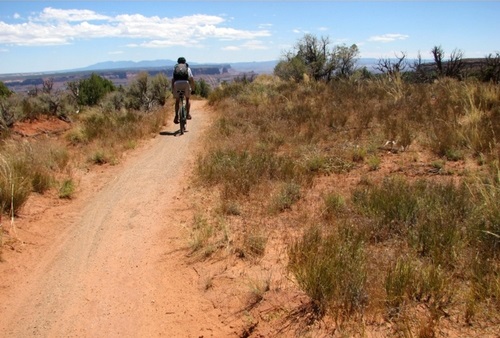
Not only is the Historic Union Pacific Rail Trail one of the most popular of Utah’s historic rail-trail routes, but it is also among the state’s most unique state parks. At 28 miles long, the Historic Union Pacific Rail Trail State Park passes through areas rich in cultural history—from the Wasatch Mountains near Park City, to wetland meadows in Silver Creek Canyon, to the picturesque small towns of Wanship and Coalville.
Dating back to the 1860s, the historic route was created to serve the mining industry. For decades during the mining heyday, it was key in transporting coal and silver ore. The railroad line was abandoned by the Union Pacific Railroad in 1989, and it would later become Utah’s first rail-trail. Mostly gravel, the trail is popular with bikers, horseback riders, cross-country skiers and walkers. The route was inducted into the Rail-Trail Hall of Fame in 2010.
Red Canyon Bicycle Trail
County: Garfield
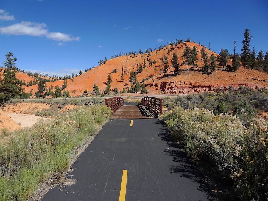
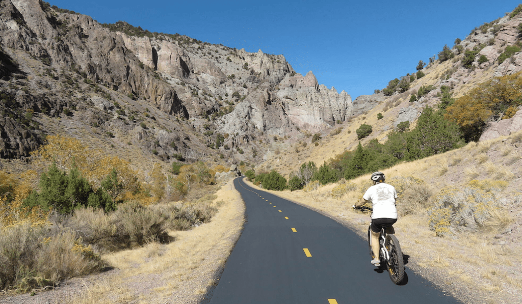
The canyons, cliffs and hoodoos of Bryce Canyon National Park and the nearby “Little Bryce” are on full display on southern Utah’s 8.6-mile Red Canyon Bicycle Trail. The paved National Recreation Trail offers a non-motorized alternative to the area’s busy Highway 12, which winds through the Red Canyon in the Dixie National Forest to a high mountain plateau.
For cyclists who want a longer route, Bryce Canyon National Park suggests the 18-mile Shared Use Path that connects the hoodoos of Red Canyon on the western edge of the Paunsaugunt Plateau with Bryce’s spectacular Inspiration Point. The five-mile Bryce Canyon Shared-Use Path section, which opened in 2016, offers cyclists, walkers and wheelchair users an easy way to explore Bryce’s iconic scenes.
Mountain bikers who want a greater challenge can connect to the Dixie National Forest’s rugged Thunder Mountain Trail, said to offer some of the most spectacular red rock formations in the state of Utah.
Pa’rus Trail
County: Washington
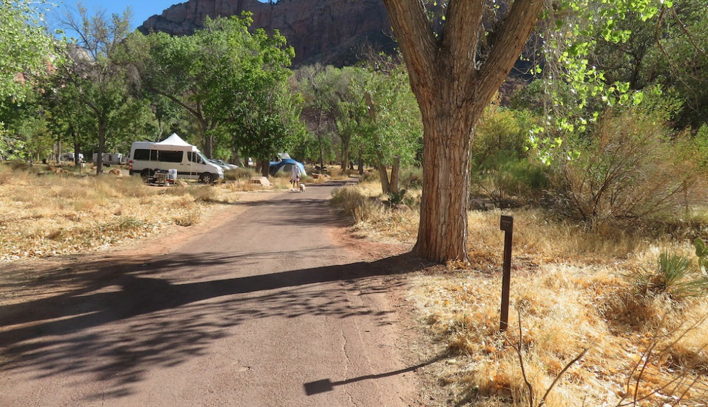
It may be short at just 1.6 miles, but the Pa’rus Trail in Zion National Park is huge on views and outdoor opportunities. As the third-busiest national park in the U.S., Zion National Park is regularly swamped with visitors, many of whom want to get to the same popular spots along the Virgin River. The Pa’rus Trail follows the route of the spectacularly scenic river canyon and offers a convenient non-motorized way to get to the park’s visitor center and spur trails along the way, as well as the Zion Human History Museum and the Zion Nature Center.
The Zion website notes that cycling is a great way to see the park and is a popular alternative to the busy shuttle buses for accessing the Zion Canyon Scenic Drive.
Virgin River Trail
County: Washington
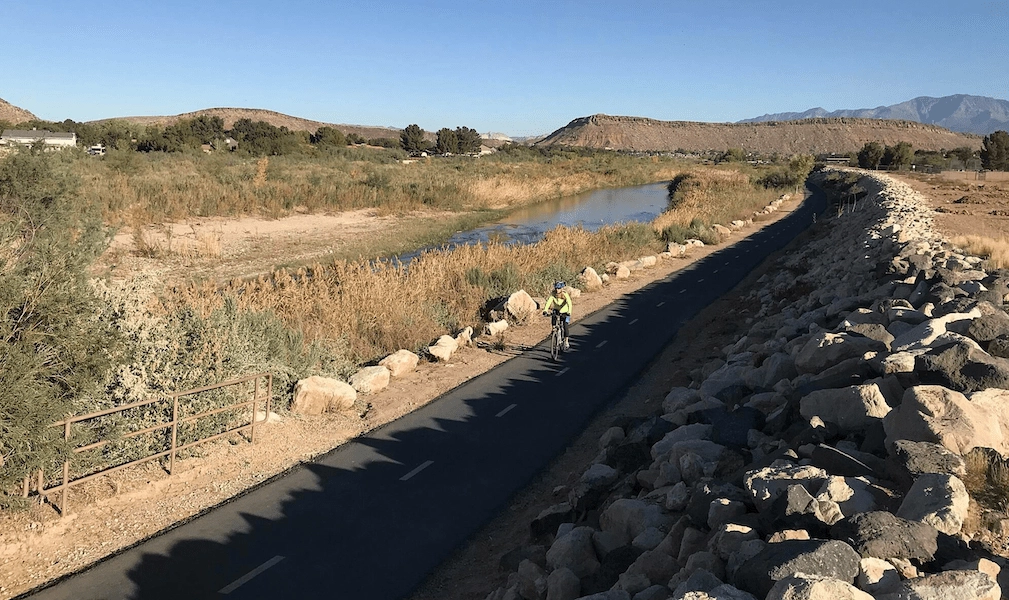
For another side of Utah’s first designated Wild and Scenic River, the 14-mile Virgin River Trail in the southwestern corner of Utah offers outstanding views of the waterway as it winds through the picturesque city of St. George.
The trail connects users to business districts, neighborhoods and parks. The Wild and Scenic River designation dates back to 2009, when the U.S. Congress designated about 165 miles of the Virgin River and its tributaries, including land in Zion National Park, as a part of the National Wild and Scenic Rivers System.
Also a part of the St. George trail system is the 7.6-mile Snow Canyon Trail, which connects users with recreational facilities in the northern part of the city, as well as the ancient lava flows and red Navajo sandstone formations at the Snow Canyon State Park (merging with the Whiptail Trail).
Candy Mountain Express Bike Trail
County: Sevier
For a taste of the mountains without the mountain-biking conditions, the 8-mile paved Candy Mountain Express Bike Trail is consistently rated as one of the top rail-trails in Utah. The trail follows the route of the former Marysvale Line of the Denver & Rio Grande Western Railroad. Along the way, it traverses canyons and colorful rock formations and offers views of the stunning Sevier River. It also passes by the late-1890s Eagle Rock Tunnel, a 200-foot-long structure that today features historical markers explaining the railroad’s history.
To the south, the trail follows the river and ends near a crossing to the Big Rock Canyon Mountain Resort, where lodging, refreshments and restrooms are available.
Murdock Canal Trail

County: Utah
Just south of Salt Lake City in the Utah Valley is the 17-mile Murdock Canal Trail, an asphalt and concrete pathway that is a part of the massive 100-mile Golden Spoke Trail Network that links Provo, Salt Lake City and Ogden. Built over a now-enclosed canal, the Canal Trail connects seven communities at the base of Mount Timpanogos.
The trail regularly gets top reviews for its pristine condition, its stellar views of the snow-covered Wasatch Mountains and its connectivity. At the southern end of the trail in Orem, users can connect with the Provo River Pathway, which weaves its way through numerous parks and residential and commercial areas before reaching the mouth of the Provo Canyon.
The Murdock Canal Trail attracts bikers, walkers and inline skaters and also has an adjacent dirt path for equestrian use. It conveniently features trailheads with restrooms every three miles or so.
Denver and Rio Grande Western Rail Trail
Counties: Davis, Weber
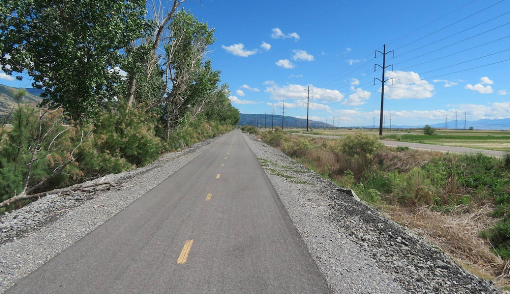
For pretty suburban scenes and world-class bird watching, the 23.5-mile Denver and Rio Grande Western Rail Trail is hard to beat. The trail runs north from West Bountiful, passing through the Salt Lake City-area communities of Farmington, Kaysville, Layton, Clearfield and Clinton. While potions of the trail front backyards of homes, other sections have the feel of wooded wilderness. The trail is a part of Utah’s Golden Spoke Network, a system of more than 100 miles of connected paved trails that stretch from Ogden to Provo.
One of the highlights located not far from Denver and Rio Grande Western Rail Tail is the Farmington Bay Waterfowl Management Area, an 18,000-acre wetland preserve managed by the Utah Division of Wildlife Resources. Over the course of the year, the management area attracts hundreds of thousands of water birds, songbirds and raptors, making it a popular spot for bird watching.
Legacy Parkway Trail
County: Davis
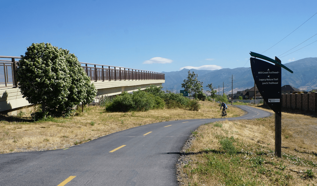
Locals gravitate to the 14-mile Legacy Parkway Trail for its efficient commuter features, such as no street crossings, bike repair stations and nearby neighborhood parks. At the same time, the Salt Lake City-area trail is known for its great views of the Wasatch Mountains, Antelope Island and the wetlands around the Great Salt Lake. It also has its share of lovely trailside scenes, such grassy horse farms and springtime wildflowers and passes by the Legacy Nature Preserve.
The trail’s location near the Legacy Parkway highway in southern Davis County and the Utah Transit Authority’s commuter rail line make it a convenient part of the region’s transportation system. It also overlaps for a time with the Denver and Rio Grande Western Rail Trail and connects with the 48.9-mile Jordon River Parkway Trail.
Like the Murdock Canal Trail and the Denver and Rio Grande Western Rail Trail, the Legacy Parkway is a part of the Golden Spoke trail network that weaves its way through the Salt Lake City area.
Provo River Parkway
County: Utah
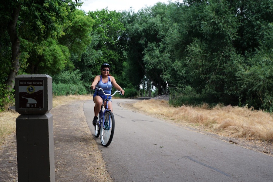
Shady tree-lined stretches give way to neighborhood parks and creek-side settings along the 15.2-mile Provo River Parkway. The parkway begins in the south at the Utah Lake State Park, which—as Utah’s largest freshwater lake—is a popular spot for boating, fishing and camping.
Along its length, the parkway passes the Fort Utah Park, the Paul Ream Wilderness Park, the Mt. Timpanogos Park and the Canyon Glen Park. In the north, the trail passes by the cascading water at the base of the striking Bridal Veil Falls. The Provo River Parkway is another section in the excellent Golden Spoke Trail Network.
Honorable Mention

The completion of Utah’s Golden Spoke Trail Network was celebrated in the Rails to Trails’ 2018 Green Issue. The photo essay showcases the natural wonders and unique infrastructure that makes up the Salt Lake City-area trail network that consists of more than 100 miles of paved trails.
When you subscribe to Rails to Trails magazine, you’ll have access to many other features like this one. Our magazine is a premium of Rails to Trails membership. Join today to start receiving the magazine!


Donate
Everyone deserves access to safe ways to walk, bike, and be active outdoors.


