California’s Mill Valley/Sausalito Multiuse Pathway
Trail of the Month: June 2023
“It’s a multi-generational trail. You’ll see kids out there and retired people of an advanced age, and people from outside of the community.”
—Veronica Pearson, the senior ecological restoration planner for Marin County Parks
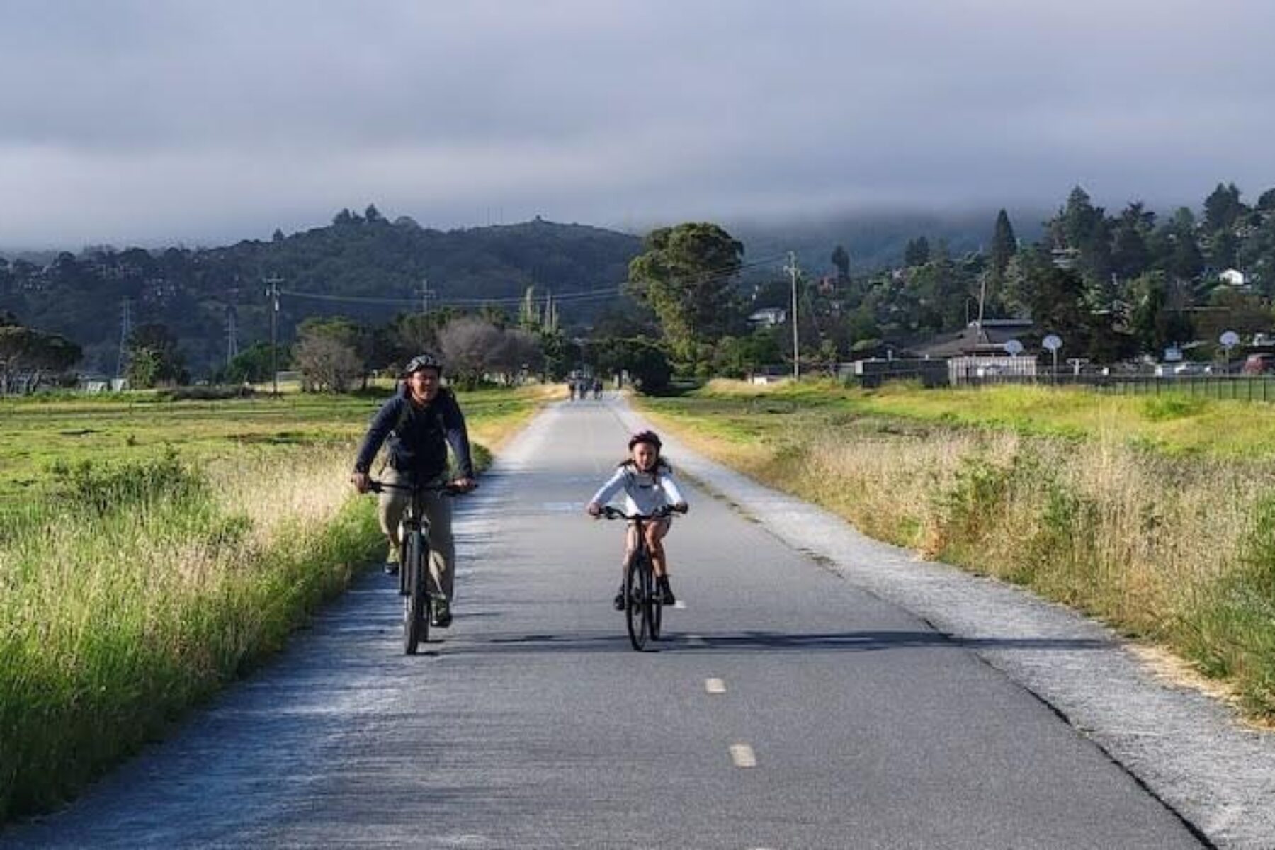
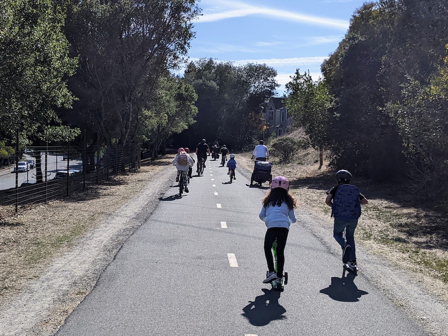
It’s a popular route for children heading to school, a place for retirees to get in a morning walk and a crucial link for bicycle commuters on their way to work. As any of its numerous advocates will tell you, coastal California’s Mill Valley/Sausalito Multiuse Pathway more than lives up to its multiuse name.
And that extends into the trail’s history as well. Starting in the early 1900s, the route that lies just north of San Francisco’s Golden Gate Bridge in southeast Marin County served as a passenger railway before being abandoned in the early 1940s and then being converted in the 1970s into a walking and biking path. Over the years, it has also been a draw as a birding area and an equestrian route.
Today, there is no doubt that the trail is deeply embedded in the history and culture of the two San Francisco Bay-area towns it connects: the mountain-foothills community of Mill Valley and the charming and historic bay-side town of Sausalito.
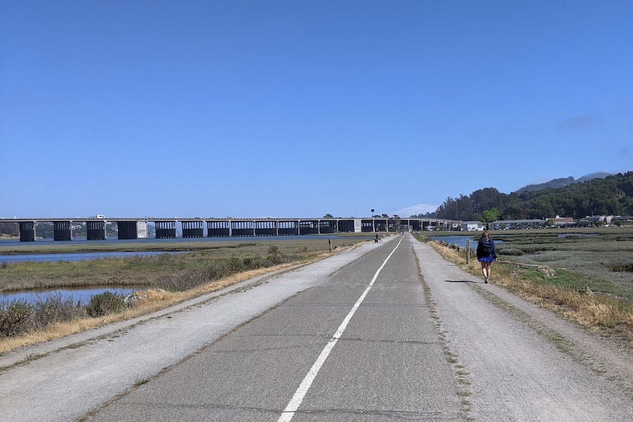
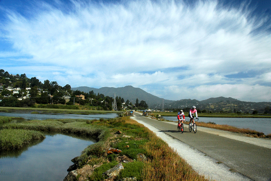
Upwards of 1,000 users head to the 3.7-mile pathway every day, pedaling and walking on the asphalt and wood-bridge surface that passes through wetlands and marshes—all with sweeping views of the region’s dominant promontory, Mt. Tamalpais (or simply Tam to the locals), as a backdrop.
“It’s gorgeous,” said Tina Torresan, communications manager for Marin County Parks, noting that going south, “You’re looking into Sausalito, San Francisco and the Bay—and coming the other way, there’s a gorgeous view of Tam.”
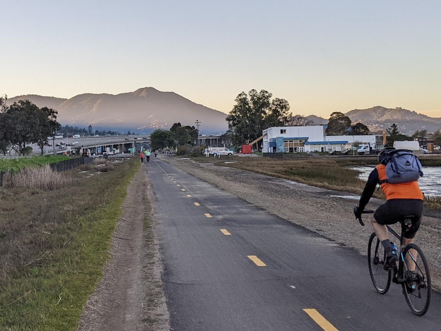
Warren Wells, the planning and policy director for the Marin County Bicycle Coalition, offers a similar view of the pathway. “The coolest thing about it is it points to the summit of Tam,” he said. “You can’t help but take it in. It is a stunningly beautiful trail.”
Still, all of that proximity to the ocean and the mountains has long come with some unique challenges, which are being exacerbated by climate change. Experts say parts of the pathway becomes engulfed by high tides multiple times a year, often affecting use of the link that is crucial in the multimodal transportation system of Marin County. That, in turn, has led to nearly a decade of studies into how to make the trail more resilient and, ultimately, preserve this key transportation and recreation connection.
A History of Connecting the San Francisco Bay
More than a century ago, the pathway’s route between Mill Valley and Sausalito was among the multiple interurban railroad lines carrying passengers throughout Marin County on the Northwestern Pacific Railroad (previously the North Shore Railroad). The line ended in Sausalito in the southeastern tip of the county, where ferries offered a connection to the bustling city of San Francisco.
By the 1930s, the rail line was already suffering from the impacts of the Great Depression, when, in 1937, the Golden Gate Bridge was completed. That opened up car commuting between Marin County and San Francisco, which further cut into the passenger railroad business. By 1941, Northwestern Pacific ended service on the passenger line, and the railroad was abandoned. It wasn’t until about 30 years later that a visionary Marin County resident saw the potential in the idle railroad line and spent years pushing for a walking and biking path.
“Elizabeth Terwilliger, or Mrs. T, as she was known, saw this abandoned railroad, and she pushed the county to adopt it as a trail,” said Tom Boss, who grew up in Mill Valley in the 1970s and 1980s and was an early user of the trail. “With Mrs. T pushing it, it has grown in popularity over the years.”
In fact, Torresan said the Mill Valley/Sausalito Multiuse Pathway is the county’s most-used route. Although a trail counter is no longer in service along the route, numbers from 2019 showed average daily use at 763 cyclists and 263 pedestrians, and the Marin County Bicycle Coalition estimates that the pathway currently attracts more than 1,000 cyclists alone every day, along with many walkers.
“It’s our most popular trail; we love that people use it,” Torresan said.
Boss, who works at the Marin County Bicycle Coalition as the off-road and events director, remembers the pathway being his window to the world while he was growing up. “It was a pathway of freedom for me as a kid,” he said, noting that he was able to use the pathway to commute to Sausalito and San Francisco.
The Sausalito Historical Society’s website lauded Terwilliger, who died in 2006 at the age of 97, as “a modern-day trailblazer.” In an oral history that is recorded at the Mill Valley Public Library, Terwilliger traced her passion for the pathway back to her desire to find a way for her children to bike to school.
Critical Link in Multimodal System
Even though the pathway’s length is short, it serves as an important link in the region’s plans for the 500-mile San Francisco Bay Trail, of which about 350 miles have been completed. “The Bay Trail is a huge project, but this section is a well-used portion of the trail,” Wells said, noting that as a car-free commuter living in Berkeley, he bikes the pathway often on his travels to northern communities like San Rafael.
“Of all of the segments of pathways in the county, this is really a crucial one because of the way Highway 101 was developed over the surface road,” he continued, highlighting that the pathway remains the only way to walk or bike between Mill Valley and Sausalito.
And for lower-income neighborhoods in communities like Marin City, the trail offers one of the only transportation options. “If you lived in Marin City (home to one of Marin County’s low-income areas) and didn’t have a car, you would have two choices: to take a bus or a bike,” Wells explained. “I see kids riding the pathway all the time.”
The rail-trail is also a key part of the expansive Bay Area Trails Collaborative (BATC) vision for a 2,600-miles-plus regional network that will connect the San Francisco Bay Area by multiuse trail. The coalition, chaired by Rails-to-Trails Conservancy (RTC) and including more than 50 partners, aims to increase safe walking, biking and trail access for millions of Bay Area residents.
“I think it is such a key piece in the trail network of Marin County,” said Laura Cohen, RTC’s Western regional director, about the Mill Valley rail-trail. “It serves so many people. I think its popularity speaks for itself. It’s a classic example of why we need to complete [the entire network]. That’s the kind of opportunity we should provide for every community across the Bay Area.”
The BATC network builds on work initiated nearly a decade ago when Marin County was one of four communities in the U.S. to be included in the federal Nonmotorized Transportation Pilot Program, which brought $25 million to each of the selected regions to demonstrate how trail infrastructure can increase human-powered forms of transportation like walking and bicycling.
Wells noted that although the Mill Valley/Sausalito Multiuse Pathway did not benefit directly from that 2014 program, many other area trails got a boost. “That grant program did fund a lot of the work in Marin County,” he said. “A lot of the [trail facilities] we have today date back to that study.”
Related: Commuting Across and Exploring the Bay Area Will Become More Accessible to Millions of Residents Via 2,604 Miles of Connected Trails
Climate Change Challenges
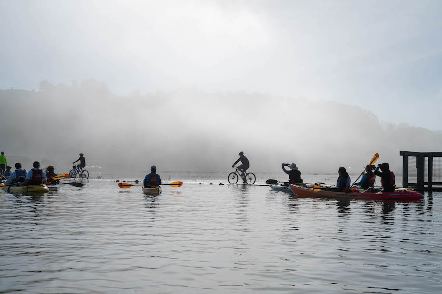
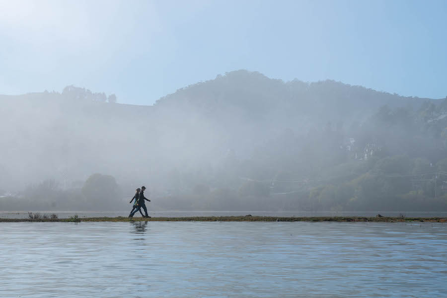
Regularly affecting the critical transportation link, however, is the flooding that occurs during high tides. Veronica Pearson, the senior ecological restoration planner for Marin County Parks, said the trail’s route through the Bothin Marsh has long made it vulnerable to flooding.
“King tides typically occur several times a year in the December–January time frame,” Pearson said. “We’re used to having parts of the trail underwater.”
But, she said, “It’s become more noticeable” in recent years. “Maybe 30 times a year, parts of the trail are underwater. I think it is one of the most vulnerable areas on the Bay Trail.”
In the past several years, the flooding situation along the pathway through Bothin Marsh has attracted news coverage in major publications like the Los Angeles Times and the San Francisco Chronicle, with photos showing cyclists and walkers traversing flooded sections of the pathway. A January 2022 article on the SF Gate website suggests that the flooding along the pathway shows what permanent sea level rise could look like in the Bay Area in the coming decades.
Pearson explains that the pathway is currently at about 6 to 7 feet in elevation. “The king tide is around 9 feet, and 9 feet is going to become more common,” she said, adding that the San Francisco Bay Conservation and Development Commission provides planning for 3.5 feet of sea level rise.
Boss remembers the pathway experiencing flooding of up to a foot occasionally while he was growing up in the area. In those days, he said, “You would just ride through it.”
These days, Pearson said the flooding has become more of an obstacle. “It is, I think, a major annoyance for the people who commute to work. It is also a popular school route.”
Since about 2015, studies have been underway on how to adapt the trail to the changing climate. In August 2021, a report titled Bothin Marsh Open Space Preserve Evolving Shoreline Adaptation Concepts laid out a number of options for making it more resilient to rising sea levels, including elevating the trail in places, spanning the marsh or detouring around the marsh. Pearson noted that the process has included extensive outreach to the communities and the pathway’s users.
Related: Trails Forecast: Resiliency and Repair (Winter 2020, Rails to Trails)
Boss said the most popular option in the community appears to be moving the trail out of the marsh. Even though it would add travel time for commuters, he said, “There are a couple of advantages: A, it wouldn’t flood, and B, it ties in nicely with some other destinations in the region. It would provide better connectivity and would help the health of the wetlands.”
All of the options are expected to be expensive, although a final cost estimate has yet to be determined. To date, the work has been supported largely by local tax measures and regional funding. In addition, federal and state resiliency grant money could be available. Pearson expects the combined planning and design processes to take several more years before construction could begin.
“There is a lot of support,” Pearson said. “It’s a multi-generational trail. You’ll see kids out there and retired people of an advanced age, and people from outside of the community.”
Related: Top 10 Trails in California
Rail-Trails: California Guidebook
Want to experience this rail-trail or some of the other great outdoor destinations in California? You’ll find maps, detailed descriptions and beautiful photos of 70+ multiuse trails across the state in our Rail-Trails: California Guidebook.
Bay Area Trails Collaborative
California’s Mill Valley/Sausalito Multiuse Pathway is part of a developing 2,600-miles-plus Bay Area regional trail network being spearheaded by the Bay Area Trails Collaborative and Rails-to-Trails Conservancy as a TrailNation™ project to increase safe walking, biking and trail access for millions of Bay Area residents.
Related Links
- Marin County Parks
- Marin County Bicycle Coalition
- Marin County Parks Habitat and Restoration
- One Tam Partnership
Trail Facts
Name: Mill Valley/Sausalito Multiuse Pathway
Used railroad corridor: The Mill Valley/Sausalito Multiuse Pathway follows the route of the Northwestern Pacific Railroad, which offered passenger service in Marin County from the early 1900s to about 1941. The electric interurban lines ran to southern Marin County in Sausalito, where connecting ferries continued on to San Francisco.
Trail website: Marin County Parks
Length: 3.7 miles
County: Marin
Start point/end point: In Mill Valley, the trail begins 0.2 miles north of Vasco Court and Underhill Road and travels south to Harbor Drive and Bridgeway in Sausalito.
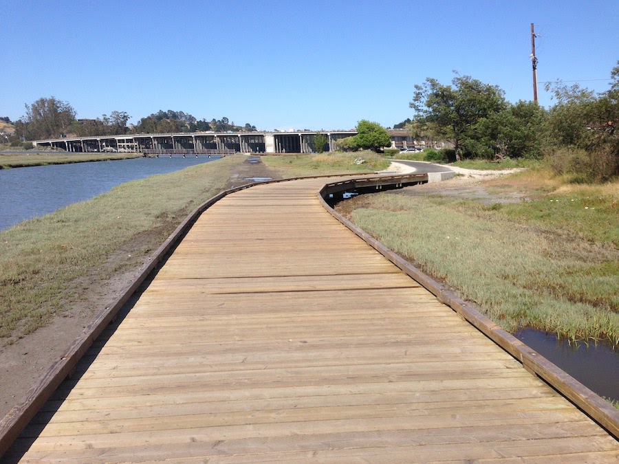
Surface type: The pathway is asphalt with a gravel shoulder that is used for horseback riding. It also has several wooden bridges over marshlands and inlets.
Grade: The grade is relatively flat.
Uses: Walking, bicycling, inline skating and horseback riding; wheelchair accessible
Difficulty: The trail provides easy access to people of all abilities and fitness levels.
Getting there: The closest major airport is San Francisco International Airport, which is about a 45-minute drive south of the trail’s northern end at the Scott Valley Swimming and Tennis Club in Mill Valley, or about a 35-minute drive to the trail’s southern end at Harbor Drive and Bridgeway in Sausalito. Trail users can also arrive at Sausalito via ferry from San Francisco.
Access and parking: Parking areas are available in Mill Valley at the Mill Valley Community Center (180 Camino Alto) and at Bayfront Park (499 Sycamore Ave.).
To navigate the area with an interactive GIS map, and to see more photos, user reviews and ratings, plus loads of other trip-planning information, visit TrailLink.com, RTC’s free trail-finder website.
Rentals: In Sausalito, bike rentals are available from Sausalito Bike Rentals (305 Harbor Drive; phone: 415.306.6927) or New Old School E-Bikes (1617 Bridgeway; phone: 415.324.7039). In Mill Valley, rentals are available from Mad Dogs & Englishmen Bike Shop (Mill Valley Lumber Yard, 129 Miller Ave., Suite 802; phone: 415.326.5141).

Donate
Everyone deserves access to safe ways to walk, bike, and be active outdoors.