California’s Sacramento River Rail Trail and Trail
Trail of the Month: October 2023
“This being my hometown, I spent my childhood on the river … people are so appreciative and use the heck out of [the trails]”
—Terry Hanson, former City of Redding city planner
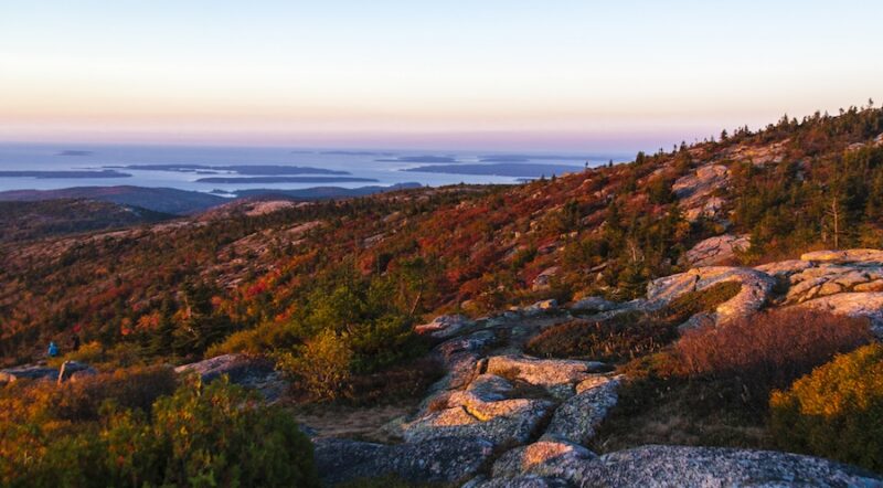
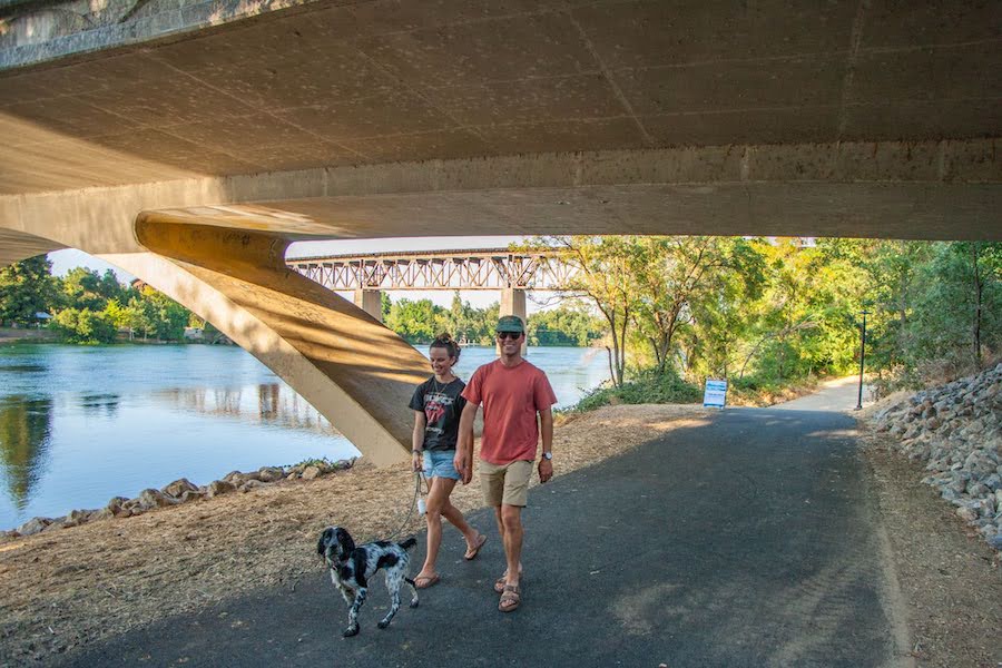
Everything about the Sacramento River is huge. Its history, its landmarks, its communities—both old and new—and, most of all, its trail system. This summer, Northern California’s dynamic trail duo that traces the river won big, entering Rail-to-Trails Conservancy’s Hall of Fame by public vote from among three nominees. The Sacramento River Rail Trail and its sister trail to the south, the Sacramento River Trail, together form a 21-mile major artery to a 200-miles-plus trail system of mostly dirt (but some paved) routes that can take users from Redding, a major urban area, into open areas of wilderness.
At its farthest northern point, the Sacramento River Rail Trail begins at Lake Shasta and the Shasta Dam. Moving south, it passes through old mining towns like Coram and Keswick until it reaches the similarly named Sacramento River Trail, which heads east into Redding. Hugging the largest river in the state for the entire journey, the twin trails are incredibly scenic, lined with picturesque bridges, opportunities to view wildlife and interpretative signs to learn the rich history of the area.
“Every day there are people out on the trails; it’s heavily utilized,” said Kimberly Niemer, Redding’s director of community service. “I frequently do the Sacramento River Trail loop once a week.”
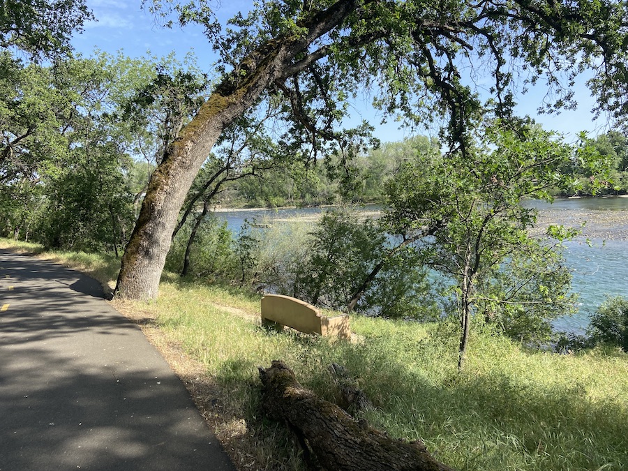
Forming a loop along both sides of the river in Redding, the Sacramento River Trail provides access to several large parks, including Lake Redding Park, Caldwell Park, Redding Memorial Park and the popular Turtle Bay Exploration Park, which includes a museum, zoo, arboretum and forested area. Niemer calls the trails the “lifeline of the community,” noting that they also host multiple events throughout the year, including fun runs, charity activities and the Redding Marathon.
Sacramento River History
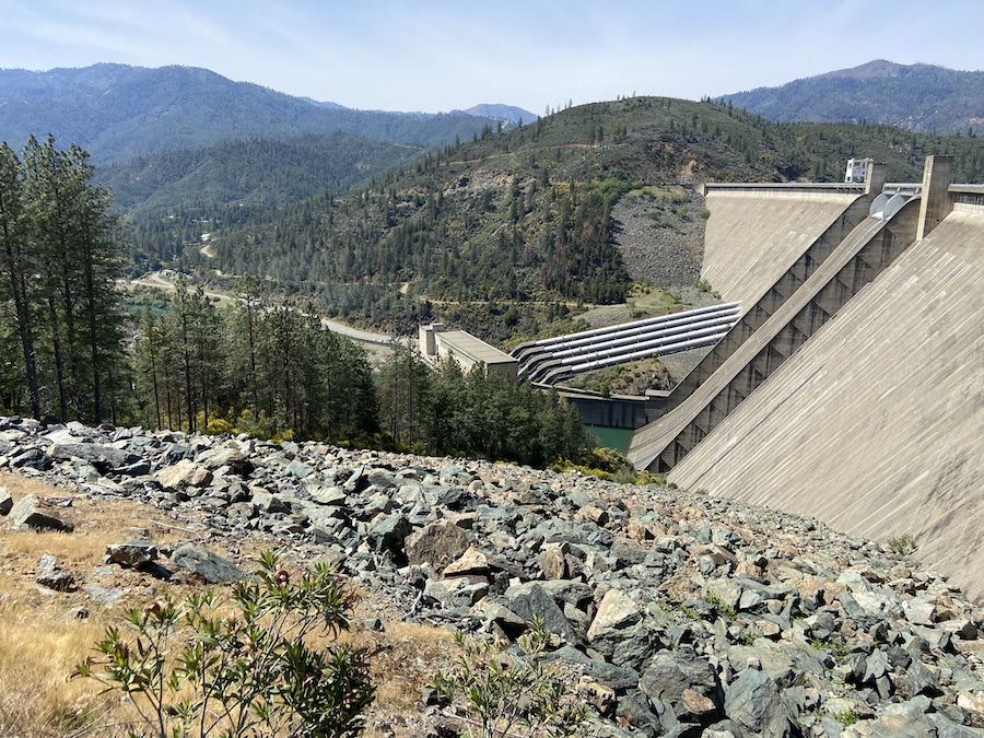
Other highlights of the trail experience are the views of the two dams built along the Sacramento River, the Shasta Dam and Keswick Dam. Both dams are part of the Central Valley Project, which helps bring power and water to the Sacramento Valley. The project was part of President Franklin D. Roosevelt’s New Deal, which funded large public works projects starting in 1933. The Shasta Dam began construction in 1937 and, measuring a whopping 602 feet in height at the time of its completion, was the eighth-tallest dam in the country.
“The visitor center is a great experience if you can schedule ahead,” said Niemer. “There are dam tours, and you can actually go inside the dam. It is a destination not to be missed if you’re in the area.”
The Sacramento River area, where the trails are today, is the ancestral homeland of the Winnemem Wintu tribe, who subsisted off the river and its plentiful run of chinook and coho salmon for generations. The tribe first encountered white people in the early 1800s and, since then, endured hardships including disease epidemics, massacres, targeted political aggression and broken government promises. Today, the tribe is part of the Redding Rancheria reservation, alongside the Yana, Shasta and Pit River tribes who also inhabited the area.
In 1848, the area around present-day Shasta County saw a surge of immigration. It was the start of the California Gold Rush and thousands of people came through the area. Towns sprung up around the Sacramento River, and the region had an influx of economic development that included lumber, sawmills, smelters and mines. The abundance of resources along the river inevitably brought the railroad to the county, too. A trestle bridge from that era still stands in Redding and is another highlight of the rail-trail later built along the river.
“Our whole town exists because of the railroad,” said Julia Cronin, the curator of collections and exhibits at Turtle Bay Exploration Park. It’s her job to know about local history, but she also loves the trails.
Cronin mentions the city’s namesake, Benjamin B. Redding, who originally arrived in search of gold but eventually became the mayor of Sacramento. After climbing the ranks of the early California political world, he became the land agent for the Central Pacific Railroad. That railroad reached Redding in 1872 and eventually connected Shasta County to Portland, Oregon. Later, the rail line was realigned to make way for the Shasta Dam.
Decades of Impact
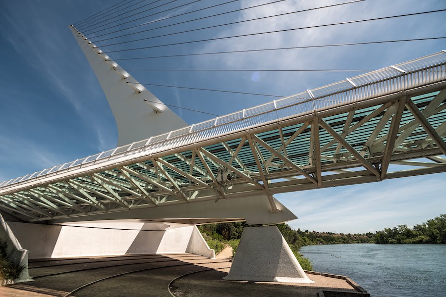
By Cronin’s estimates, the trails and Turtle Bay Exploration Park bring in at least 100,000 people annually, and she suspects that the Sundial Bridge is the major draw to the park. The Sundial Bridge, the largest fully functioning sundial in the world, also doubles as a pedestrian walkway and public art installation.
“Instead of being an art museum, instead of being a history museum, we’re an everything museum,” said Cronin. “We do art, we have an animal and horticulture element, we sell plants. Come for the porcupine, stay for the Picasso!”
Cronin has lived in the Redding area since 1997 and can practically walk to the trail from her backyard. When the trails were new and freshly paved, she remembers cycling all the way up to the Shasta Dam alongside the city planners, field managers and the many others who helped bring them to life.
Terry Hanson’s life work revolves around preserving outdoor areas and he helped develop the trail system along the Sacramento River. Now 71 years old, Hanson still remembers playing along the riverbeds as a child back when Redding was a much smaller town.
“It was magical to play around the river, the old roads, the animal trails,” he recalled. “It’s a beautiful environment.”
His involvement with the trail professionally goes back to when he was Redding’s city planner. He partnered with then Bureau of Land Management (BLM) recreation supervisor Bill Kuntz. While the Sacramento River Trail in Redding is managed by the City of Redding, the northern section of rail-trail is on BLM land. Over the course of decades, starting in 1970—together alongside other partners such as the Turtle Bay Exploration Park, Bureau of Reclamation and multiple volunteer groups—the city of Redding and BLM were able to bring the Sacramento River trail duo to life.
Hanson still isn’t done with the trails. He says the route is set to go farther south 4 miles in a section that’s disconnected from City Hall and Turtle Bay. Plans also call for the trail to reach nearby Anderson City along the Anderson Cottonwood Irrigation System, which collects water for agriculture.
“That’s a long way off,” Hanson admitted. For now, he’s busy developing open space along the river and trails called NurPon, which means “Salmon Run” in the Wintu language that will help create a channel to benefit the salmon native to the river.
“This being my hometown, I spent my childhood on the river, but the other thing is … people are so appreciative and use the heck out of [the trails],” enthused Hanson.

Related:
RTC’s Hall of Fame
In 2007, RTC began recognizing exemplary rail-trails around the country through its Hall of Fame. Hall of Fame trails have been selected based on merits such as scenic value, high use, trail and trailside amenities, historical significance, excellence in management and maintenance of facility, community connections and geographic distribution.
Related Links
Trail Facts
Name: Sacramento River Rail Trail and Sacramento River Trail
Used railroad corridor: Central Pacific Railroad
Trail website: City of Redding
Length: Combined, the trails offer 23.4 miles of trail with the north-south Sacramento River Rail Trail spanning 11.1 miles and the east-west Sacramento River Trail spanning 12.3 miles (including the loop on both sides of the river).
County: Shasta
Start point/end point: On its northern end, the Sacramento River Rail Trail begins at the Shasta Dam Trailhead on Coram Road, 2.8 miles south of the Shasta Dam Visitor Center. From there, it travels south to the FB Trailhead on Keswick Dam Road, 0.4 mile south of Keswick Dam, where it meets the Sacramento River Trail. The Sacramento River Trail heads east, ending in Redding at the intersection of Dana Drive and Hilltop Road.
Surface type: Asphalt
Grade: Most of the trail duo has a grade of 5% or less. Note that near the southern end of the Sacramento River Rail Trail, in the Keswick area, there is a steeper section that trail users will encounter after crossing Spring Creek; it winds through the hills flanking the Keswick Reservoir.
Uses: Walking, biking, inline skating and fishing; wheelchair accessible
Difficulty: With a paved surface and relatively gentle grade, the trail provides an easy to moderate experience for most trail users.
Getting there: The Redding Regional Airport (6751 Woodrum Cir., Redding) is located 9 miles from downtown Redding and the Sacramento River Trail.
Access and parking: Sacramento River Rail Trail parking areas are located within Redding and are listed from north to south:
- Shasta Dam Trailhead: Gravel parking lot off Coram Road, 2.8 miles south of Shasta Dam Visitor Center (40.7112, -122.4408).
- Keswick Boat Ramp: Keswick Lake Ramp Road, 0.3 mile southeast of Iron Mountain Road (40.6324, -122.4530).
- Keswick Trailhead: West St./Rock Creek Road and Iron Mountain Road (40.6247, -122.4660).
- FB Trailhead: Keswick Dam Road, 0.9 mile southeast of Iron Mountain Road (40.6100, -122.4481).
Selected parking areas for Sacramento River Trail areas are listed below, listed from west to east and located within Redding:
- Diestelhorst Bridge (northside): Benton Drive, 0.1 mile south of Quartz Hill Road (40.5949, -122.4023).
- Diestelhorst Bridge (southside): Middle Creek Road and Benton Drive (40.5918, -122.4024).
- McConnell Arboretum and Botanical Gardens: 1500 Traveled Way (40.5932, -122.3851).
- Turtle Bay Exploration Park: 872-880 Sundial Bridge Drive (40.5900, -122.3783).
To navigate the area with an interactive GIS map, and to see more photos, user reviews and ratings, plus loads of other trip-planning information, visit TrailLink.com, RTC’s free trail-finder website.
Rentals: For bike rentals in Redding, visit Pedego Electric Bikes (1374 Hilltop Drive; phone: 530.605.450). Redding’s bikeshare program has stations across the city, including at the Sundial Bridge, Redding Transit Center, Redding City Hall and Diestelhorst Bridge along the trail. For a complete list visit shastalivingstreets.org.

Donate
Everyone deserves access to safe ways to walk, bike, and be active outdoors.