Connecting Ashtabula to Pittsburgh by Trail
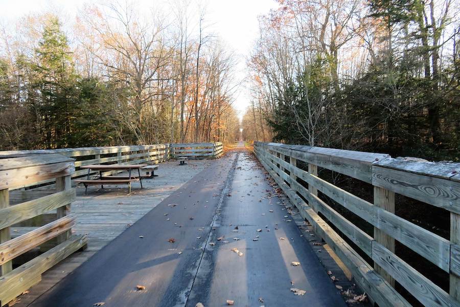
Three Rivers Heritage Trail in Pittsburgh, Pennsylvania | Photo by Renee Rosenteel
Two States, 150 Miles of Trail, Inviting Exploration

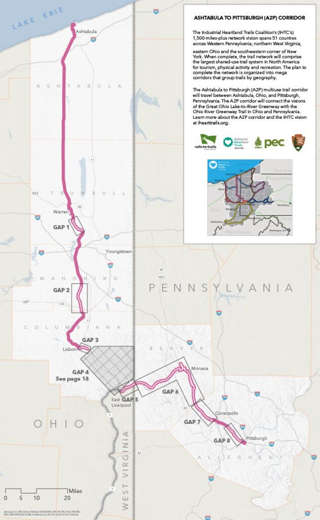
The Ashtabula to Pittsburgh (A2P) corridor travels from the shore of Lake Erie in Ashtabula, Ohio, to the confluence of the three rivers at Point State Park in Pittsburgh, Pennsylvania. The visionary project would offer transformational opportunities for outdoor recreation, transportation and economic development in both states. Finding a way to complete the development of trails to fill the gaps in the corridor could transform the economy of the region and the many communities along the corridor.
This feasibility study, produced by Rails to Trails Conservancy (RTC), highlights opportunities along the trail as well as challenges to close the gaps in the corridor. Work is already underway to close several of the gaps in Ohio, and the communities in Pennsylvania along the A2P corridor have the energy and momentum to complete their portions as well.
A Feasibility Study of the Industrial Heartland Trails Coalition’s Ashtabula to Pittsburgh Corridor
A contiguous trail connecting the region’s biggest assets with the Great Allegheny Passage (GAP) (gaptrail.org) would transform the corridor into a premier destination sought out by people from across the country and around the world. The A2P trail will also connect to the larger, 1,500-miles-plus planned trail network that the Industrial Heartland Trails Coalition (IHTC) envisions spanning 51 counties through West Virginia, Pennsylvania, Ohio and New York—further expanding its tourism potential.
The goal of completing the A2P corridor is about more than building a trail. It is about leveraging the trail to build a sustainable regional economy and to rebuild many of the communities along the A2P corridor that have been buffeted and abandoned by cataclysmic changes in the manufacturing and energy industries over the years. Realizing that vision will require closing the remaining trail gaps across six counties, including a gap in Ohio where a viable route has not been identified. The task is difficult but rewarding, and officials, local leaders and trail advocates in both states will have a crucial role to play.
Trail networks have been proven to be effective tools in revitalizing communities, sparking new local business opportunities, and attracting and retaining residents. Connected trails are powerful assets that will make local cities and towns better places to live, work and do business.
For evidence, we need not look very far. The GAP through Southwestern Pennsylvania was largely responsible for reviving and reinventing many of the small rural communities through which it passes. Before the trail was created, many communities were skeptical that such amenities could have any impact on their economy. Today, the GAP sees more than 1 million users annually and is responsible for tens of millions of dollars in direct user spending annually to local economies. A study of the GAP corridor, published in November 2021, found that trail users had an overall regional economic impact of more than $121 million. A similar opportunity is available along the A2P corridor.
This study by RTC, combined with the “Connecting Parkersburg to Pittsburgh by Rail-Trail” study and “Sheepskin Trail Feasibility Study,” both published in 2018, and the “Connecting Cleveland to Pittsburgh by Trail” study published in 2019, completes a series of comprehensive analyses of existing conditions and recommendations for closing the gaps within several corridors in the IHTC footprint. In addition, the Pennsylvania Environmental Council—a partner in the IHTC—along with many stakeholders, conducted a gap assessment of the Erie to Pittsburgh and Pennsylvania Wilds corridors in 2020. Together, this body of work has built a roadmap for the effort needed to reach the vision of the IHTC—to establish the Industrial Heartland as a premiere destination offering a 1,500-miles-plus multiuse trail network experience.
This study presents a strong blueprint, and highlights major challenges, to making a trail along the A2P corridor a reality—identifying funding sources, partnership opportunities, and the planning and municipal processes required to complete undeveloped gaps. This corridor has been envisioned since the 1980s, and many of the original champions are still actively engaged in realizing the dream. As this study details, considerable challenges continue to exist. With over 30 years of progress underway, and impressive existing trails on the ground, local support for completing the A2P continues to grow.
The publication of this study is a moment to reflect and congratulate those Ohio and Pennsylvania trail advocates and their allies across the region that have brought us so close to realizing the A2P connection. Simultaneously, it is important to recognize that the only way to adequately pay tribute to their efforts is to complete the job, and unlock the significant economic, community, health and social benefits that will come with finally making Ohio and Pennsylvania integral parts of a new, and truly world-class, trail system.

Project Background
Imagine what’s possible with a 1,500-miles-plus trail network that connects 51 counties in four states—person by person, town by town, community by community, state by state. This is the vision of the Industrial Heartland Trails Coalition (IHTC): establishing the Industrial Heartland as a premier destination offering a unique multiuse trail network experience that will stretch across New York, Ohio, Pennsylvania and West Virginia—from the shores of Lake Erie to the confluence of the three rivers in Pittsburgh (the Allegheny, the Monongahela and the Ohio) and on to the Ohio River and Appalachian foothills in West Virginia.
The IHTC builds upon past efforts to organize the trails community, connect regional trails to each other, leverage the cultural heritage of the region into a leading multiuse trail destination, and harness and amplify the benefits of the region’s trail systems. Trail groups from the region joined together in the early 2000s, eventually forming a coalition in 2011 and branding themselves the “Industrial Heartland Trails Coalition” in 2015 in an effort to collectively advance the vision of a trail network across the region.
Grouped by geography, eight identified trail destination corridors make up the IHTC network. The Ashtabula to Pittsburgh (A2P) corridor extends from the shores of Lake Erie at Ashtabula, Ohio—utilizing existing well-loved trails such as the Western Reserve Greenway—and connects across the Ohio River into Pennsylvania. The corridor then connects to the Three Rivers Heritage Trail in Pittsburgh and beyond.
What’s in a Name?
Most of the “destination” corridors within the IHTC footprint are currently named for their two termini and often abbreviated (e.g., Ashtabula to Pittsburgh becomes “A2P,” Cleveland to Pittsburgh becomes “C2P,” etc.). These names and abbreviations are intended to be used to reference the work during the current planning and gap-filling phase. As existing trails are extended and new trails built to fill in the gaps, a branding and naming process could occur to create more marketable names and unique brands for each corridor.
Project Scope
This study is the first and only comprehensive look at the A2P corridor within the IHTC. The corridor is anchored by Ashtabula, Ohio, a lakefront city along Lake Erie, and Pittsburgh, Pennsylvania. Many communities large and small are found along the corridor, including (but not limited to) Warren, Canfield, Leetonia, Lisbon and East Liverpool in Ohio and Beaver, Monaca and Coraopolis in Pennsylvania.
Project Partners
The IHTC and the A2P corridor build on the previous and ongoing work of local trail organizations; conservation and community-based groups; and federal, state and local governments. More than 100 agencies and organizations are actively engaged in the IHTC effort. Currently, more than two dozen organizations and local governments in Ohio and Pennsylvania have engaged in meetings and other activities indicating their interest in connecting the A2P corridor. These organizations include, but are not limited to, the following:
Ohio
• Ashtabula County MetroParks
• Columbiana County Park District
• City of East Liverpool
• City of Lisbon
• Mill Creek MetroParks
• National Park Service—Rivers, Trails, and Conservation Assistance Program
• Trumbull County MetroParks
Pennsylvania
• Allegheny County Executive Office
• Beaver County Park District
• Friends of the Riverfront
• Riverlife
• RiverWise/Ohio River Trail